
Tracking TD 8 & TD 9. New Wave Also Set To Move Off Africa
The Atlantic basin is certainly coming to life as we near the end of the month. With the peak of the season just around the corner, it's no surprise that we are tracking two systems and possibly a third in a few days. We are tracking TD 8 located east of the Carolinas and TD 9 in the Florida Straits. It will likely be a race to see which depression can achieve tropical storm status first. The next two names are Hermine and Ian.
We will begin this discussion with TD 8. After organizing quickly earlier today, the low-level center of the depression is now exposed due to 15 to 20 knots of southeasterly wind shear. The environment is only marginally conducive for intensification and the official forecast from the National Hurricane Center brings this depression to tropical storm status within the next 24 hours.
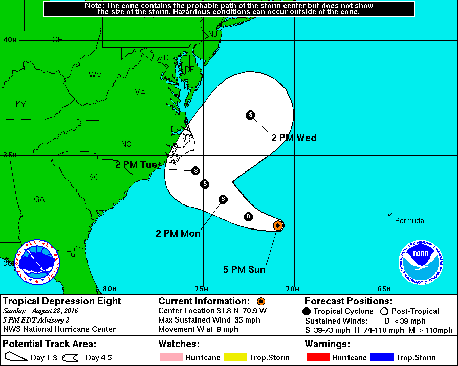

TD 8 will track west-northwest generally towards the Outer Banks of North Carolina before slowing down and re-curving just offshore in a few days. A tropical storm watch has not been issued due to the uncertainty in the intensity forecast and the timing of the approach to the coast. At this time, impacts are expected to be minimal with the most active weather remaining offshore. For those of you in eastern North Carolina, we have issued low alert levels and the best thing to do is just check in a couple of times today on the progress of the system.

Of greater concern is TD 9 which is located in the Florida Straits. It's moving towards the west and is forecasted to strengthen into a tropical storm within the next 48 hours. This system should track into the central Gulf of Mexico and slowly intensify while it heads towards the Big Bend of FL later this week. There is a medium amount of confidence in the forecast cone and low confidence with the intensity forecast. All of the global computer models such as the European and the GFS, do not strengthen this to anything more than a low to moderate tropical storm. Hurricane models such the HWRF & GFDL intensify the system into a hurricane before making landfall in Florida. Currently, the National Hurricane Center only forecasts peak winds to reach 50 mph on Thursday before making landfall Thursday night.

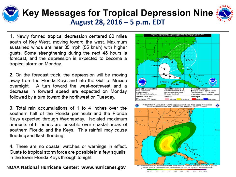

We have issued guarded alert levels for portions of the north & northeastern gulf coast, please see the graphic and the key below. All interests and residents from the Mississippi/Alabama border down through the West Coast of Florida should closely follow the system throughout the week. It will be a slow mover and the waters in the Gulf of Mexico are in the mid to upper 80s in some areas. If upper-level conditions are favorable, it's possible the system could strengthen more than what is currently forecast.


As we get into this weekend, there is still a chance the system could track close to the Georgia, South Carolina, and North Carolina coastlines before turning out to sea. Of course the long term track beyond 5 days is still highly uncertain.
We will be tracking this system closely throughout the week with discussions, audio updates and analysis from the Hurricane Tracker App team.
If those two systems were not enough, we will likely be tracking a new tropical wave wave that is set to come off the coast of Africa with in the next 48 hours. The National Hurricane Center states this tropical wave has a 50% chance of development through the next five days. Current computer model guidance suggests that this system could be steered west across the Atlantic ocean underneath a building ridge of high-pressure. Needless to say, the system will be watched very closely over the next several days.

We want to thank you for using the Hurricane Tracker App and we hope that the information we provide is useful. We will be back with another discussion as conditions warrant.