
WED 5/6/15 - 9AM EDT - Development & Impacts Likely THU-SUN
For the past several days we have been monitoring the possibility of early-season development along the SE US coastline. The models have come into reasonably good agreement on the track and intensity. Officially, the NHC states there is a 60% chance of development within 48 hours (medium). The area of low pressure has been designated Invest 90L by the NHC, our first of the season. The Hurricane Hunter mission for today has been canceled and rescheduled for tomorrow. The low should really start to tighten up and organize tonight and into tomorrow morning.

Latest Infrared Satellite Image - 8AM EDT

8AM EDT Outlook from the NHC
Intensity - Just about every model is forecasting a 40-50 mph sub-tropical storm by Thursday. A couple of models even develop this low into a full fledged, warm core tropical system. We do have a couple of outliers such as the HWRF & CMC which forecast winds a bit stronger, but under hurricane force. Overall, we believe this will not be a big inland wind event and peak winds should be around 50-55 mph.
Track - We feel pretty confident that the storm track will be towards the SC or lower NC coastline by Thu/Fri. There is a good chance it makes landfall or nears the coast and slows down for a couple of days. Due to the forecasted slow speed of the storm, coastal flooding and beach erosion to the right of the center will be the main impacts along with rough surf conditions. The storm will either fizzle out just on or near the coast, or be pushed out to sea by an incoming trough of low pressure next week.

Expected Impacts Based On The Latest Data
Timing - The main impacts to the SC/NC coastlines should begin on Thursday and possibly last through the weekend. This will be a slow moving system and as a result, the biggest impacts will be coastal flooding and beach erosion.
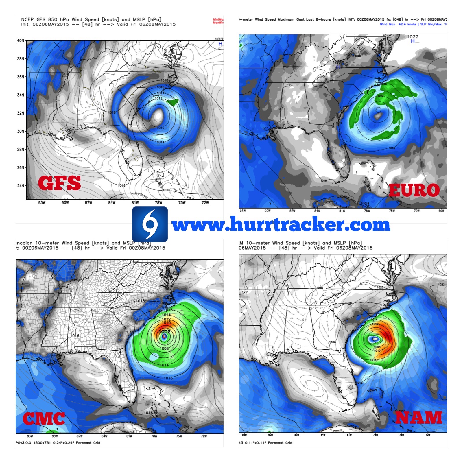
Models Are In Good Agreement In Regards To The Track 48 Hours From Now
All residents and interests from the GA to North Carolina coast, please pay close attention to this developing weather system throughout this week as there is strong potential of a subtropical or tropical storm forming and affecting the coast before the week is out. We will continue to provide updates as more data becomes available. If you are a Periscope user, please follow us (hurricanetrackerapp) as we will be providing live, short video broadcast with the latest models and information from time to time. Thank you for using Hurricane Tracker. We will have another update sometime tomorrow.

Risk Level Of Being Impacted Within 5 Days - Issued By The Hurricane Tracker App
*NEW! If you would like to sign up to receive our detailed discussions via email as soon as they are published, please visit this link: http://bit.ly/hurricaneupdates
Latest Audio Update: http://bit.ly/1cHTE10 (New one coming this afternoon).