
Major Hurricane Dorian Poses a Significant Threat to FL, the Southeast & NW Bahamas
Hurricane Dorian is now a major category 3 storm with winds of 115 mph as of this discussion. A hurricane watch is in effect for the northwestern Bahamas. Dorian is moving towards the northwest at 10 mph and is expected to turn towards the west during the next 24 hours as a sub-tropical ridge of high pressure builds to its north and east. Unfortunately, this westerly turn will place the hurricane on course to impact the northwest Bahamas and Florida later this weekend and into early next week.


Environmental conditions will be favorable for Dorian to strengthen even further over the next few days. Currently, the National Hurricane Center forecasts the winds to peak around 140 mph three days from now. There is a possibility, that the storm could end up a little stronger than forecast given the favorable environmental conditions and very warm waters throughout the southwest Atlantic. Many times the last several years, wind shear and or dry air have been able to keep systems relatively weak, but it appears those factors will not be in place to prevent another major hurricane strike in Florida.
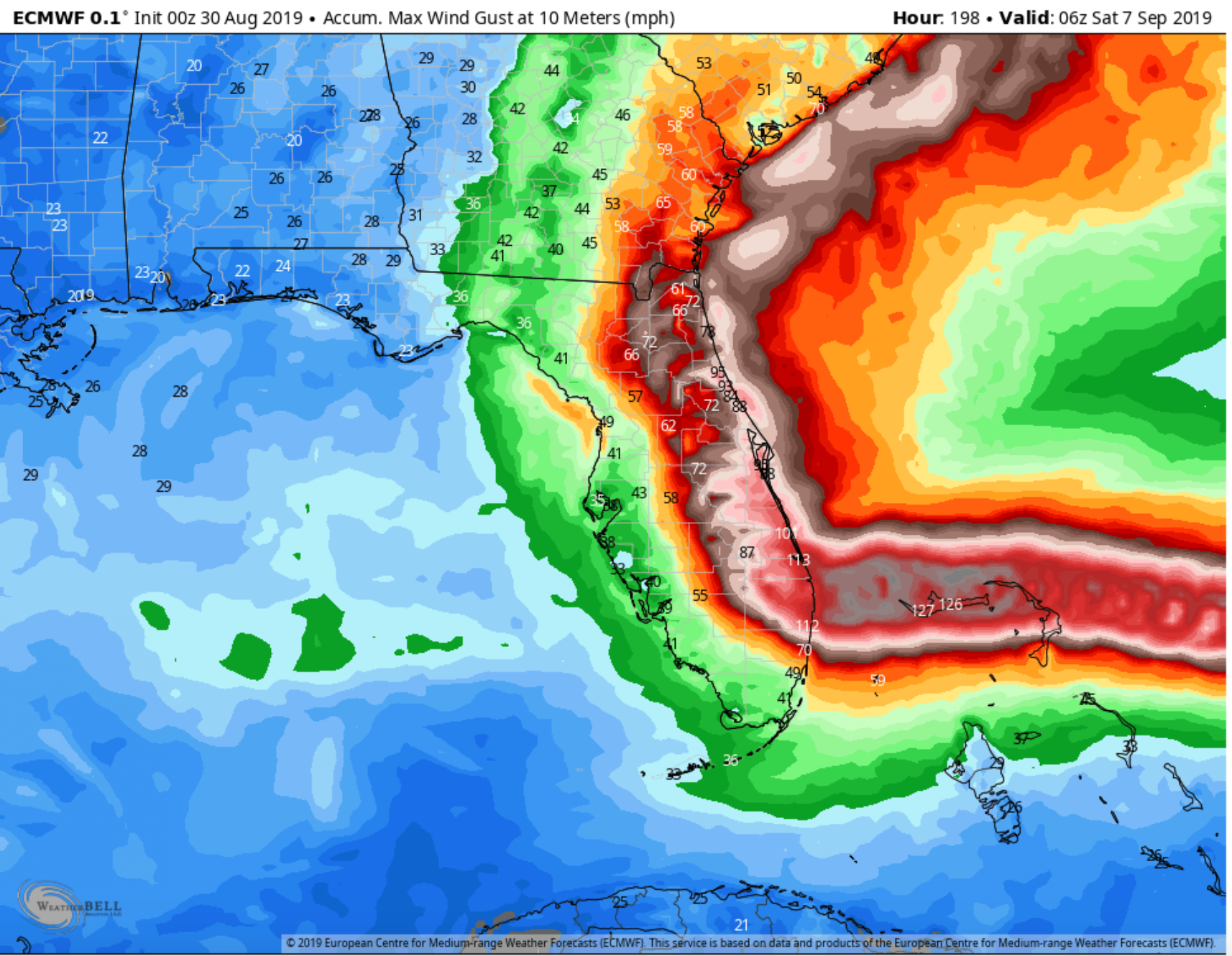
Wind gust forecast (mph) from the EURO model shows the possible scale of wind impacts.

Rainfall forecast for Dorian.
Computer model guidance is in strong agreement that Dorian will track across the northwestern Bahamas Sunday or Monday and make landfall somewhere along the east Florida coast Monday night or Tuesday. No one at this time can predict exactly where the center will come ashore (assuming it doesn’t stay just offshore) along the Florida coast, but the general thinking is somewhere between West Palm Beach and Cape Canaveral Florida. As Dorian nears Florida, steering currents are going to weaken dramatically and the system is going to slow down and move slowly bringing torrential rainfall, damaging winds and very dangerous storm surge along the coast. Once Dorian makes landfall in Florida, The hurricane will likely make a sharp right turn and move north throughout the rest of the Florida peninsula into southeast Georgia and the eastern portion of the Carolinas. There is still a low chance that the storm could make the right turn just offshore of Florida which would definitely be a much better scenario than the one we are looking at now. With each passing hour chances are lowering that there will be a significant change in the overall track. We fully expect that tropical storm and hurricane watches will be issued for portions of Florida by tomorrow evening. At this time, chances are low that the storm will enter the Gulf of Mexico.

5 Day EURO ensemble tracks.
If you are in the within NHC cone, you should begin preparing for this storm as it will be a dangerous, high impact event that may last several days in some areas. Make sure you have a hurricane kit and plan in place. Listen to your local officials as they know your area the best and heed all evacuation warnings if issued. The best case scenario is that Dorian will make a northerly turn just off of the coast keeping the biggest impacts offshore and the worst case scenario is we have a major hurricane moving south to north through the Florida peninsula and portions of the southeast impacting many places. If you are in southeast Georgia and the eastern Carolinas, please pay close attention to the forecast track of Dorian over the next few days as the system may impact portions of the southeast United States later next week.


Thank you for using the hurricane tracker app and we will have another email update as conditions warrant. Thank you.