
The Peak of the Season Is Here; Florence Is A Major Concern
Below is our latest discussion & it will be updated as conditions warrant. For the most up to date information on a storm, please visit the “Current Storms” section in the app.
September 10th is historically the peak of hurricane season. It definitely is this year as we have three hurricanes and a disturbance in the Western Caribbean that we are monitoring. We will cover all of these systems in today's discussion, but most of this discussion will be focused on major Hurricane Florence and the dangers it poses to portions of the southeastern and mid-Atlantic United States.
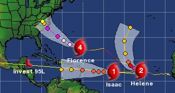
Hurricane Helene: Helene brought tropical storm conditions to the Southern Cabo Verde Islands and it's now moving away and is expected to turn north into the open Atlantic later this week and will not affect anymore land. Helene will likely become the second major hurricane of the 2018 Atlantic Hurricane Season.


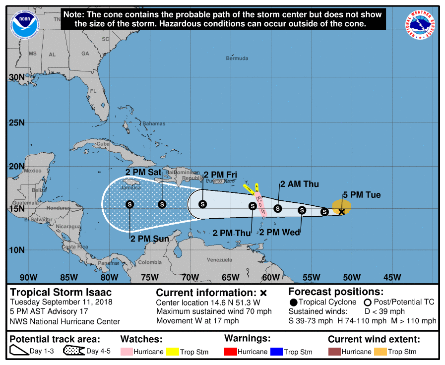
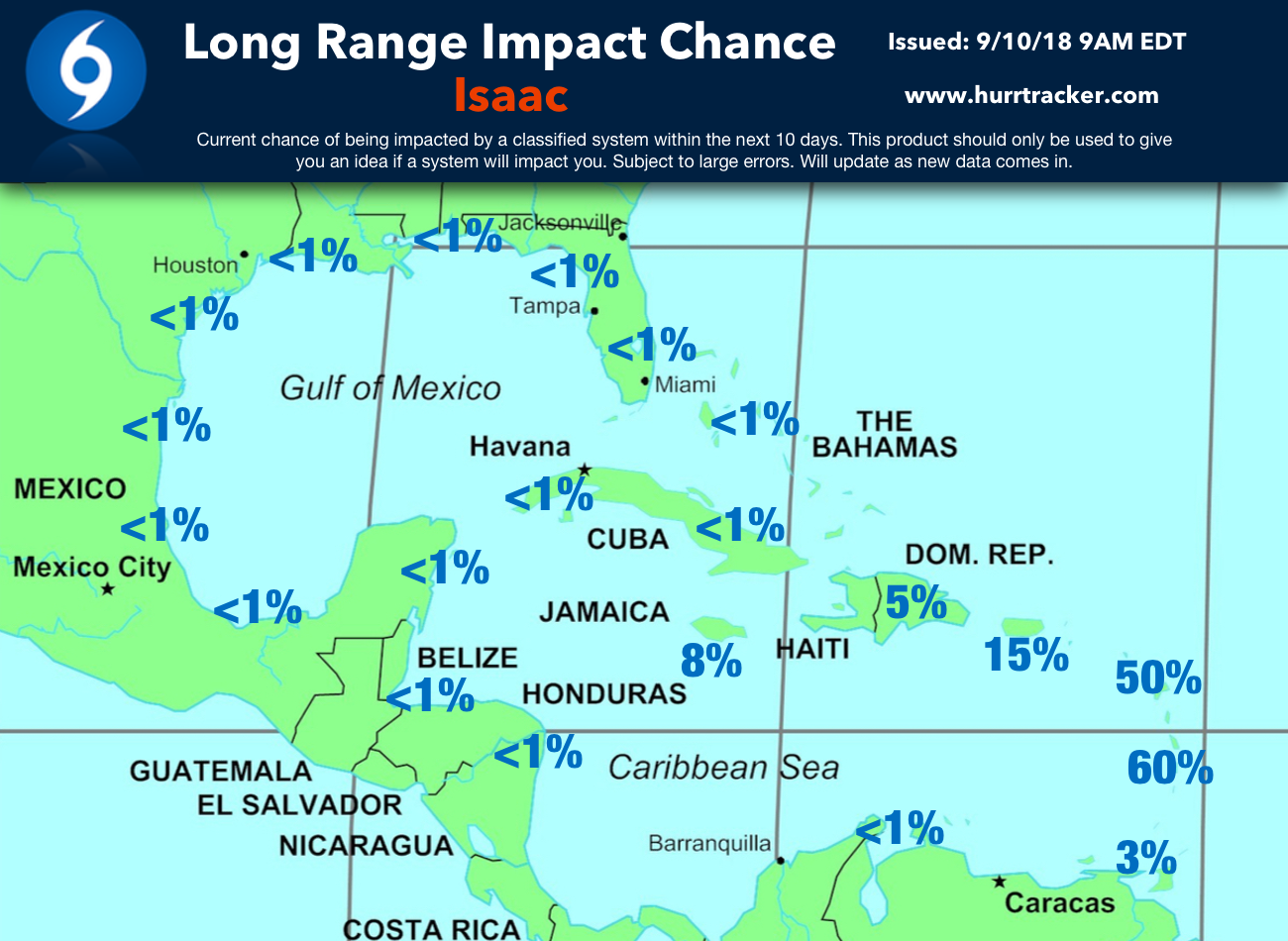
Tropical Storm Issac: Isaac has not become better organized and was downgraded to a tropical storm. Isaac is a small system and tropical storm force winds extend out up to 45 miles from the center. Isaac is forecasted to continue moving to the west towards the Lesser Antilles. Isaac is also forecasted to strengthen a little further (back to hurricane status) during the next 24 hours while wind shear is low, but after 24 hours, increasing wind shear should limit any further intensification. The intensity forecast has lower confidence than normal. Based on all the latest data, Isaac should be at or near hurricane strength as it passes through the central or northern Lesser Antilles on Thursday. Once the hurricane reaches the central Caribbean Sea it should weaken and possibly dissipate due to unfavorable upper level conditions. Interests in the Lesser Antilles should monitor all future forecasts of this system closely. Below you will see our latest 5 Day Alert Levels & Impact chance map for Isaac.


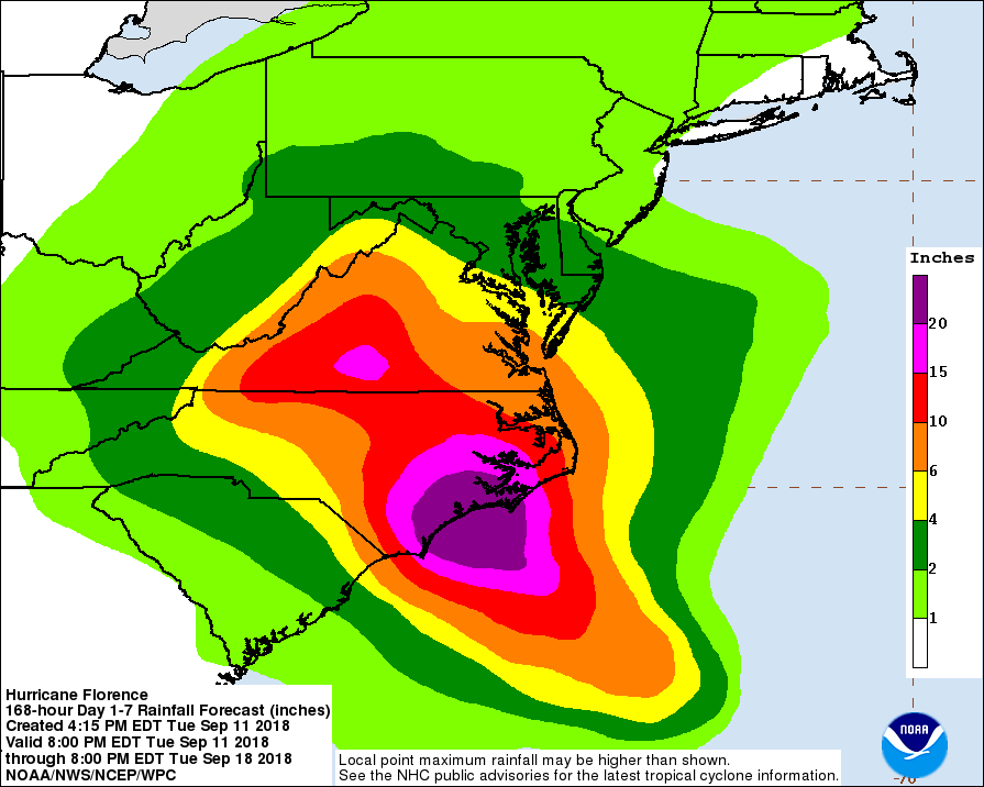
Major Hurricane Florence: Florence rapidly intensified back to a major hurricane and winds are near 140 mph which makes Florence a category 4 hurricane. Florence has turned and is now moving west-northwest. The hurricane will be in a very favorable environment up until landfall. The NHC does forecast Florence to strengthen and winds should peak around 150 mph. The hurricane is being steered by a strong upper level ridge of high pressure located to its north. This will force the hurricane west-northwest towards the coast and a landfall is expected somewhere within the NHC’s cone along the SC/NC coastlines Thursday afternoon. Once the system moves inland, all indications are that it will likely stall or move very slowly which would bring major inland flooding to portions of SC/NC/VA into the weekend. Those of you in or near the cone should be beginning to execute your hurricane plan and as always listen to the advice of your local officials. Unfortunately, Florence will be a catastrophic hurricane as there will be multiple threats including major wind damage, catastrophic storm surge, and dangerous flash flooding. Hurricane & Storm Surge watches are in effect. Please review our 5 Day Alert Levels and Impact chances below for more information on the risk areas.


Invest 95L: Last but not least, and area of disturbed weather associated with a surface trough in the Western Caribbean Sea has been showing some signs of organization. Currently, this system has a 70% chance of development during the next five days as it moves into the southern Gulf of Mexico. Some of the modeling data does indicate this could become a depression or a minimal tropical storm once in the western Gulf of Mexico and could potentially move inland along the Texas coastline later this week.

Thank you for using the Hurricane Tracker App and we will have an updated discussion as the forecast warrants.