
Hermine May Stall Off The Mid-Atlantic Coast & Become a Hurricane Again
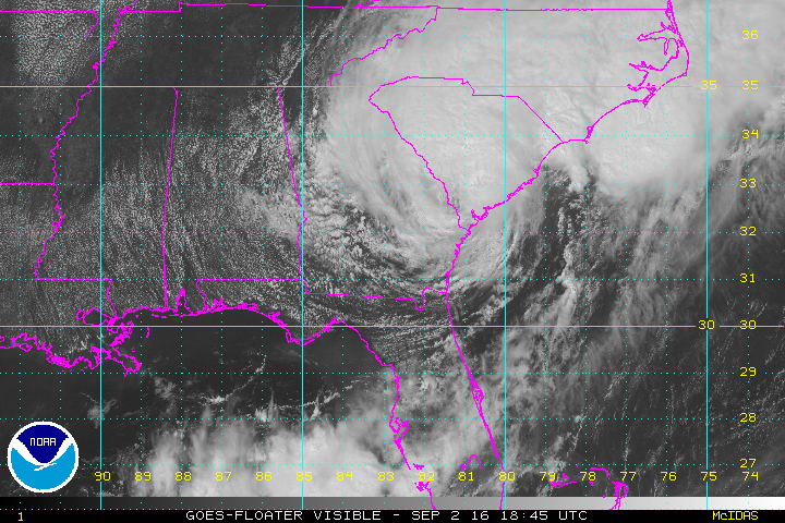
Hurricane Hermine made landfall last night in FL and has been tracking through the southeast today as a tropical storm, bringing winds over 40 mph and several inches of rain.
If you would like to receive these updates the moment they are published, please click here to sign up for email updates.
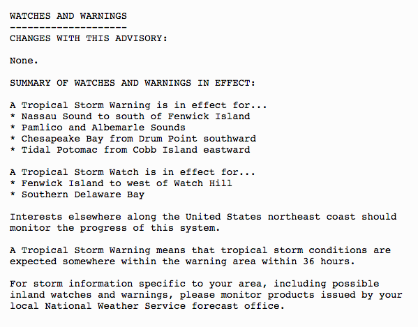
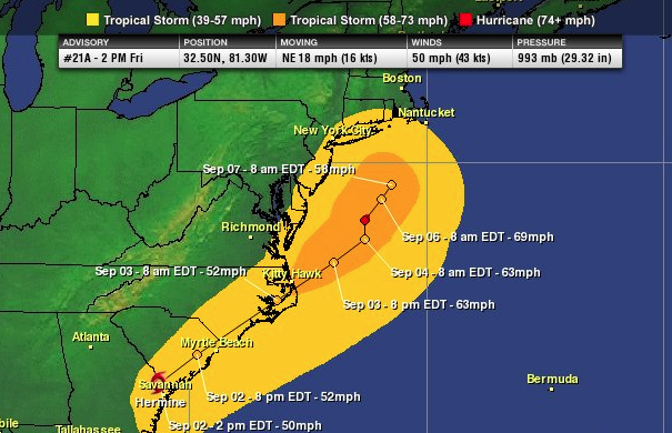
TS warnings are in effect from the coast of GA up through the Delmarva Peninsula. Tropical storm watches are in effect from Delaware up to the CT/RI border, including Long Island and NYC. Please see the image below for the complete list of watches & warnings as issued by the NHC.
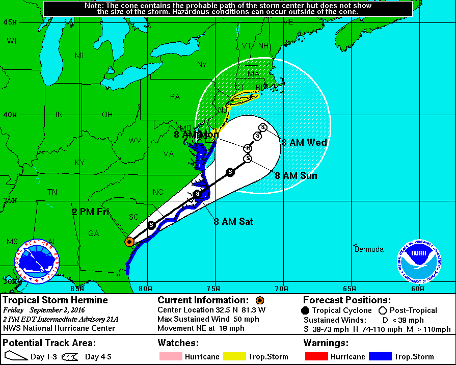
Once Hermine exits the coast of NC tomorrow morning, it should be able to strengthen back to a hurricane by Sunday or Monday. The water temperatures off the mid-Atlantic coast are running above average and there is plenty of ocean heat content for the system to strengthen.
The exact track of Hermine beyond Saturday is still little uncertain and therefore, the NHC has a fairly wide cone Sun-Wed. One thing we know for sure is that Hermine will not be able to make a quick escape out to sea as an area of high pressure will build to the north, preventing a path out to sea. There is a possibility that Hermine could make landfall, but at this time the most likely solution is that Hermine will stall just offshore of the mid-Atlantic coast for a few days and eventually begin to weaken or move out to sea Wednesday or Thursday.
12Z EURO model run today shows a closer track towards the coast.
Even if Hermine does not make landfall, the effects could be devastating to some portions of the coast. At minimum, tropical storm force conditions, heavy rain and a storm surge of 3-5’ feet are possible from Long Island down through SE Virginia. We encourage anyone who has Labor Day plans along the coast to make alternate plans. The closer the system tracks towards the coast, the worse the effects will be. To make matters even worse, some guidance is strengthening Hermine into a CAT or CAT 3 hurricane just offshore. Unfortunately, this could be a devastating setup for some portions of the mid-Atlantic coast early next week. All residents and interests in the regions should complete preparations by tomorrow afternoon.
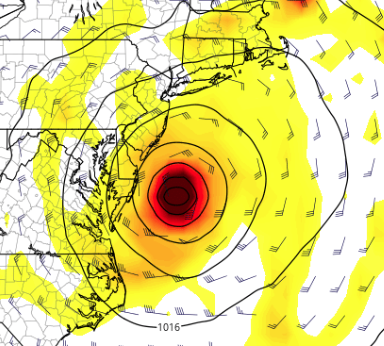
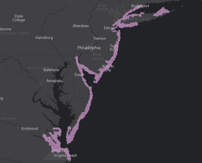
Latest wind swath projection based on the latest NHC forecast.
Storm surge watch is in effect per the NHC.
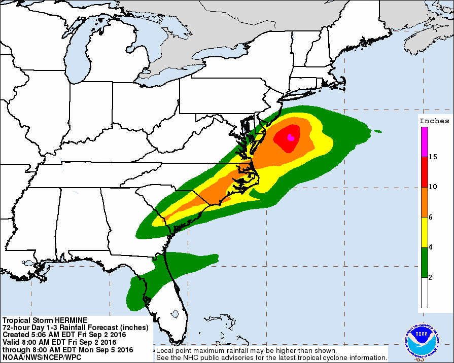
Rainfall projection based on the latest NHC forecast.
Please note, there is a HIGH amount of uncertainty in the exact track and intensity of Hermine early next week. We encourage you to follow the forecast from the NHC and your local NWS office.
If you need more in-depth information on the potential impacts to the mid-Atlantic/northeast early next week please watch our latest video update here: Tropical Storm Hermine May Bring Multiple Impacts To The Mid-Atlantic.
If you want more frequent updates, we encourage to join our Twitter feed as we will post frequent updates on Hermine throughout the weekend and early next week www.twitter.com/hurrtrackerapp. Thanks for using Hurricane Tracker and have a great evening.