
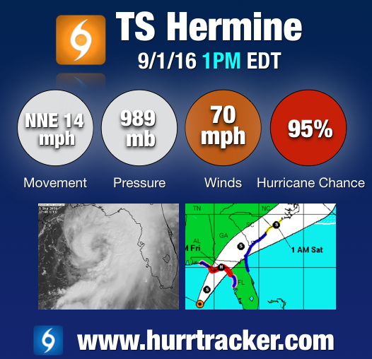
1PM EDT Tropical Storm Hermine Update - Almost a Hurricane
...TROPICAL STORM WARNING EXTENDED SOUTHWARD ALONG FLORIDA GULF AND
ATLANTIC COASTS...


SUMMARY OF 1200 PM CDT...1700 UTC...INFORMATION
-----------------------------------------------
LOCATION...27.8N 85.6W
ABOUT 135 MI...220 KM SSW OF APALACHICOLA FLORIDA
ABOUT 190 MI...305 KM W OF TAMPA FLORIDA
MAXIMUM SUSTAINED WINDS...70 MPH...110 KM/H
PRESENT MOVEMENT...NNE OR 30 DEGREES AT 14 MPH...22 KM/H
MINIMUM CENTRAL PRESSURE...989 MB...29.21 INCHES


WATCHES AND WARNINGS
--------------------
CHANGES WITH THIS ADVISORY:

The Tropical Storm Warning has been extended southward along the
west coast of Florida to Englewood, including the greater Tampa/St.
Petersburg area, and southward along the east coast of Florida to
the Flagler/Volusia County line.

SUMMARY OF WATCHES AND WARNINGS IN EFFECT:

A Hurricane Warning is in effect for...
* Suwannee River to Mexico Beach

A Hurricane Watch is in effect for...
* Anclote River to Suwannee River
* West of Mexico Beach to the Walton/Bay County line

A Tropical Storm Warning is in effect for...
* Englewood to Suwannee River
* West of Mexico Beach to the Walton/Bay County line
* Flagler/Volusia County line to Surf City

A Tropical Storm Watch is in effect for...
* North of Surf City to Oregon Inlet, including Pamlico Sound

Interests elsewhere along the United States mid-Atlantic and
northeast coast should monitor the progress of this system.

For storm information specific to your area, including possible
inland watches and warnings, please monitor products issued by your
local National Weather Service forecast office.
Follow our Twitter feed www.twitter.com/hurrtrackerapp for frequent updates as the system makes landfall tonight. If you are in the path, please stay safe!