
9/29/15 - Joaquin Is An Extremely Difficult Forecast
Probably the most difficult in years. The NHC notes "Very low confidence" in their forecast. In some ways, this forecast is more difficult that Erika's back in August because the upper air features involved are much more complex that what we had during Erika. The Hurricane Hunters have been flying the tropical storm and are finding stronger winds as Joaquin is beginning to strengthen. Wind shear is beginning to weaken and we expect this trend to continue. Receive our detailed discussions via email as soon as they are published, please tap here.

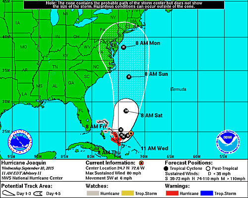
At this hour, the computer models are split on what happens to Joaquin in the long term (4-6 days out). However, in the short term models do agree that Joaquin will intensify into a hurricane by Thursday and possibly threaten portions of the Bahamas with hurricane conditions Thursday-Friday. We expect hurricane watches to be issued soon for portions of the Bahamas. In fact, Joaquin could be a Category 2 or 3 in 48 hours as atmospheric conditions improve while the storm sits over very warm waters of the western Atlantic.
If you are a resident, or have interests in the Bahamas - please follow the forecast from the NHC VERY closely as there won't be much lead time to prepare. Beyond the Bahamas, you can see just how split the guidance is. Some tracks lead Joaquin out to sea, while many show a major threat to the U.S. east coast. It's really too early to tell where the storm will end up in 4-6 days as the pattern is just too complex for the models to handle well right now. There's plenty concern that a strong hurricane could impact the east coast this weekend - this cannot be ruled out. Hopefully, the track will become much clearer in 48 hours or so. Expect the models to go back and forth until then. Always take a single model run with a grain of salt, as a blend of the models and the trends is always best in these complex situations.

Here is our 5 Day Alert Levels Map. This should be used as a guide to know what your awareness level should be as of right now. Again, all interests with an alert level of 1 or higher should keep close tabs on future forecasts and updates.

2 possible tracks are on the table and neither can be ruled out yet. Be mindful and alert.

What are the realistic chances that Joaquin will come your way given what we know right now?
OUR LATEST INSTAGRAM POSTS: @hurricanetracker


Please stay tuned here at the Hurricane Tracker App for frequent updates on Joaquin throughout this week.
We highly recommend following our Twitter (hurrtrackerapp) for real time coverage as the new data comes in every 6 hours.
A new post will be issue sometime on Wednesday afternoon, usually before 5PM EDT. Please check the Real Time Feed for TS Joaquin on the storm page for frequent snippets from us as the data changes.
If you value our service, please leave a quick review for us in the App Store. Click on a link below & you will be taken to our app in the store. Thanks so much!
Open App Store: iPhone Version
Open App Store: iPad Version
Thanks! ~ Hurricane Tracker App Team
Copyright 2015 | Hurricane Tracker App | EZ Apps, Inc.