
9/28/15 - TS Joaquin Forms, Eastern U.S. Coast Should Be On Alert
While activity has been fairly steady this season in the Atlantic basin, there hasn't been any systems to threaten the United States since Tropical Storm Erika a little over a month ago. The peak of the Atlantic hurricane season was the second week of September, but the basin can sometimes stay active through mid October, especially if the ocean temperatures are above normal as they are this year. Receive our detailed discussions via email as soon as they are published, please tap here.

Western Atlantic Ocean Temperature Anomalies.
On Saturday, we began tracking Invest 98L which was an area of low pressure that formed from an upper level low. It's rare for an upper level low to transition to a surface low, but in this case that transition was aided by the above average ocean temperatures in the Western Atlantic.
Invest 98L strengthened into TD 11 yesterday and into TS Joaquin tonight. In about 12 to 24 hours, wind shear is forecasted to relax, which should allow Tropical Storm Joaquin to strengthen some. Over the next three days, the system will move to the west-northwest and could even get within 75 miles of the NE Bahamas by mid week. Later this week, an upper level trough along the east U.S. coast should turn the system towards the north with an increase in forward speed.


The 5 day forecast cone from the NHC does include portions of the coast from NC to MA. At this time, the NHC is only forecasting Joaquin to intensify into a 50 mph tropical storm. It is important to note that some models, including the reliable EURO/HWRF models, forecast a much stronger system (hurricane) just off the coast by Saturday. The NHC notes their confidence in the intensity forecast is very low.
We are confident that the system will eventually turn towards the north, but will it end up on the coast in NC, or 50-100 miles offshore from New England? Those details, along with the intensity, are impossible to hammer out at this juncture. Regardless of the exact track and intensity, heavy rains will be a big concern for portions of the Mid-Atlantic and Northeast as this system moves towards the north later this week. The potential for flooding rains will be high even though the system will be moving fairly quickly. Many times this late in the season, we have a cold front that helps turn these systems NE away from the coast. That does not appear to be the case at all as models forecast a strong, blocking ridge of high pressure over NE Canada which will act like a wall and keep the cyclone close to the coast or push it inland. This is a very similar steering pattern that Sandy had. At this point, we could have anything from a weak depression to a strong hurricane affecting someone from NC to ME this weekend. This system will need to be watched closely due to the players on the field we have outlined (warm ocean temps, incoming trough & blocking high). All interests along the U.S. Eastern seaboard should monitor future forecasts very closely and check in with the app often for the latest advisories and maps.
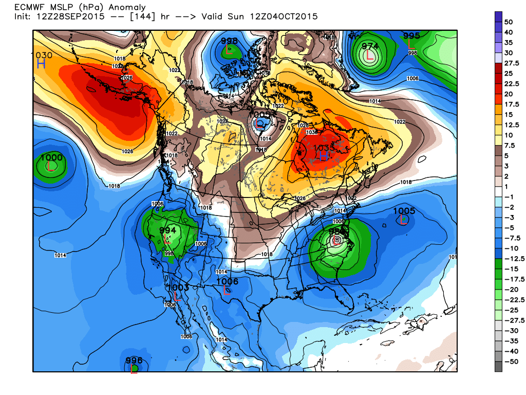
A strong, large area of high pressure is forecasted over NE Canada which will keep TD 11/Joaquin form recurving out to sea.

Anyone from SC to Canada should keep a close eye on the tropics this week.

Long Range Impact Chances from The Hurricane Tracker App.
Please stay tuned here at the Hurricane Tracker App for frequent updates on Joaquin this weekend.
We highly recommend following our Twitter (hurrtrackerapp) for real time coverage as the system tracks towards the coast.
A new post will be issue sometime on Tuesday afternoon, usually before 5PM EDT. Please check the Real Time Feed for TS Joaquin on the storm page for frequent snippets from us as the data changes.
If you value our service, please leave a quick review for us in the App Store. Click on a link below & you will be taken to our app in the store. Thanks so much!
Open App Store: iPhone Version
Open App Store: iPad Version
Thanks! ~ Hurricane Tracker App Team
Copyright 2015 | Hurricane Tracker App | EZ Apps, Inc.