FRI 8/28/15 - TS Erika Likely To Weaken Further. US Threat Diminishing
Note: This section is updated every afternoon with our analysis. Next post by 5PM EDT Saturday. For real time info, visit Erika's page under "Current Storms" for all the latest maps, models & advisories. Thanks.
Since our last discussion, Tropical Storm Erika has remained disorganized and has continued to move west, instead of wnw as forecasted by the NHC. The NHC has continued to shift their track and cone to the west in response. We expect this trend to continue, which will bring the weak low level center very near Hispaniola and Cuba overnight. Due to land interaction & continued wind shear, this should cause Erika to open into a tropical wave. This solution is supported by the latest model runs. Look for the NHC to continue making westward adjustments in their upcoming forecasts. We think the chances of Erika opening into a wave are around 60%. The main threat from Erika will be the possibility of 5 to 10 inches of rainfall, locally higher amounts, across portions of the Dominican Republic & Haiti through tomorrow morning. Receive our detailed discussions via email as soon as they are published, please tap here.
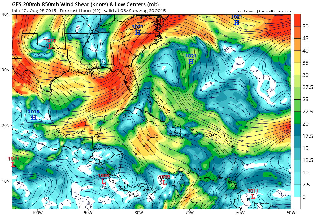
We will be watching very closely to see what Erika does once she gets away from land and back into open water. A few of the computer models show Erika might be a tropical depression or a weak tropical storm somewhere near the south coast of Florida or in the far eastern Gulf of Mexico by early next week. We do know for certain that waters in the Florida Straits and the eastern Gulf of Mexico are some of the warmest on earth right now. However, Wind shear across the Gulf of Mexico early next week is forecasted to be very high (see image below). This will definitely limit any possible reorganization. Of course that's still a few days out and It's always possible the models could be wrong with the wind shear forecast. Heck, they have been wrong so far on Erika's path. A deep upper level trough is forecasted to be located over the western Gulf of Mexico, which would allow for strong southwesterly windshear over the central and eastern Gulf by the time Erika arrives in the area. If you are a resident or have an interest anywhere in the eastern Gulf of Mexico, including Florida, please continue to keep an eye on the forecast even though the threat for major US impacts are diminishing. Erika will likely be just a rain producer, which would be welcome news to parts of Florida as long as too much doesn't fall at one time. We will be here all weekend and early next week with the latest developments on TS Erika. If you are a new user to the Hurricane Tracker App, we thank you for downloading it and for using our service. We hope you find the information in the app helpful. We hope everyone has a great weekend.
Forecasted wind shear across the E Gulf next week is very high.
Current Hurricane Tracker App projected track & Alert Levels.
Please stay tuned here at the Hurricane Tracker App for frequent updates on TS Erika this weekend.
We highly recommend following our Twitter (hurrtrackerapp) for real time coverage as the system tracks westward.
A new post will be issue sometime on Saturday afternoon, usually before 5PM EDT. Please check the Real Time Feed for Erika on the storm page for frequent snippets from us as the data changes.
If you value our service, please leave a quick review for us in the App Store. Click on a link below & you will be taken to our app in the store. Thanks so much!
Open App Store: iPhone Version
Open App Store: iPad Version
Thanks! ~ Hurricane Tracker App Team
Copyright 2015 | Hurricane Tracker App | EZ Apps, Inc.


