
THU 8/27/15 - Erika Is No Easy Forecast
Note: This section is updated every afternoon with our analysis. Next post by 5PM EDT Friday. For real time info, visit Erika's page under "Current Storms" for all the latest maps, models & advisories. Thanks.
Erika is beginning to feel like a broken record. Deep thunderstorm activity builds, the storm appears to be organizing, then upper level windshear exposes the low level circulation by pushing the strong thunderstorms away from the center. Even though the storm is not very organized, it has dropped tremendous amounts of rainfall on the island of Dominica, which has led to devastating floods (see image below). Even weak tropical storms and depressions can cause major issues. Heavy rains will continue to batter portions of the NE Caribbean Sea through the next 48 hours, including Puerto Rico. Tropical storm warnings remain in effect. Winds are not going to be a big deal across the region, as the environment remains unfavorable the next couple of days for Erica to strengthen due to wind shear and land interaction. There is still a chance the storm may not survive and could dissipate if it loses what little organization it has. You may find this hard to believe, but back in 2009, the last time the name "Erika" was used, the storm dissipated in the same region (see image below). Overall, the storm appears to be growing in size despite the lack of organization. We have a feeling we're going to be talking about the storm for the next 5 to 7 days. Receive our detailed discussions via email as soon as they are published, please tap here.
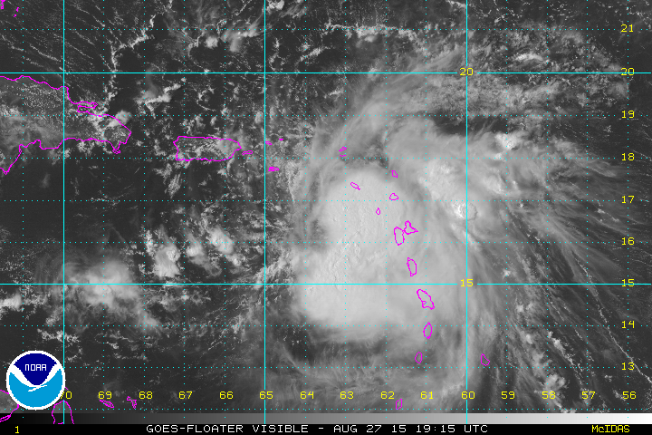
Erika remains disorganized this afternoon.

Devastating flooding has occurred today on the island of Dominica leading to 4 deaths.

Erika back in 2009 dissipated in the same where 2015's Erika is located.
TRACK: Erika has been primarily moving towards the west, but a slight turn towards the wnw should happen soon or Erika will continue south of the official NHC track which could cause land interaction with the island of Hispaniola. Also, any further deviation from the forecast, will cause forecast track changes down the road. There is still a chance Erika could dissipate much like Danny did if it becomes unable to fight off the shear. The official forecast from the National Hurricane Center at this time calls for Erika to skirt just north of Hispaniola. The computer models have REALLY been struggling with Erika. After trending to the east away from FL yesterday, most of them have trended back west as has FL in the bullseye. At this juncture, it's best to focus on the cone and not the actual track since we do not have an organized system, yet. The models don't mean too much without an organized area of low pressure. Erika is no easy forecast as the long term and possible US impacts depend on how she does over the next 1-2 days. Keep in mind, we are still 4-5 days away from potential impacts, this forecast will no doubt be modified a few times. This has been one of the most challenging storms we have tracked.


INTENSITY: Erika will be in an area not conducive for strengthening during the next 48 hours. Once Erika starts moving past Hispaniola, it will be entering a more favorable environment that is conducive to strengthening. A good chunk of the computer model guidance takes Erika to a category 1 hurricane as it moves wnw through the Bahamas Saturday and Sunday. The two factors that may allow Erika to intensity in the Bahamas will be very warm ocean temperatures and a favorable upper-level environment with little to no wind shear. The water temperatures in the Gulf of Mexico and near the Bahamas are some of the warmest on the planet. Some parts are running near 90F! Needless to say, if Erika survives the next 48 hours, she will have an opportunity to strengthen into a hurricane. We will be watching the intensity forecast very closely over the coming days. Very low confidence on Erika's intensity as we head into the weekend.
Possible US Threat? All models agree on a strong ridge of high pressure to the north of Erika, which would prevent the storm from curving out to sea. In fact, some guidance is showing a possible stall or even a loop. The chance of Erika escaping away from United States is low. If Erika is somehow able to strengthen into a hurricane, it may be able to turn more towards the north and skirt FL just to the east towards GA/SC/NC. Yes, there is still the potential of a landfalling hurricane (could even be a strong one) in the United States, but it's not set in stone. Please continue to follow future forecasts from the NHC closely. As of this post, we are giving a 25% chance that Erika will impact the United States, this has decreased a bit yesterday due to the uncertainty with the storm in the short term. These chances will likely rise further if Erika holds together over the next day or so (we think it will). Please see our latest Long Range Impact Chances Map below to see what the % chance is of Erika affecting any one given area.

Alert Levels: We have issued Alert Levels for portions of the region in anticipation of possible effects from Erika this week. Please review the image below to see what your alert level should be at this time.

Please stay tuned here at the Hurricane Tracker App for frequent updates on TS Erika this week.
We highly recommend following our Twitter (hurrtrackerapp) for real time coverage as the systems track westward.
A new post will be issue sometime on Friday afternoon, usually before 5PM EDT. Please check the Real Time Feed for Erika on the storm page for frequent snippets from us as the data changes.
If you value our service, please leave a quick review for us in the App Store. Click on a link below & you will be taken to our app in the store. Thanks so much!
Open App Store: iPhone Version
Open App Store: iPad Version
Thanks! ~ Hurricane Tracker App Team
Copyright 2015 | Hurricane Tracker App | EZ Apps, Inc.