
SAT 5/8/15 8PM EDT - TS ANA MAKING LANDFALL TONIGHT
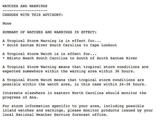
Tropical Storm Ana is approaching the SC/NC coastlines and will make landfall during the early morning hours on Sunday. Winds are sustained at 60 mph with higher gusts. Recent satellite data suggests convection is deepening and Ana may be getting a bit stronger. Ana is approaching water temps that are in the low-mid 70's and should weaken some before landfall. Tropical Storm Warnings & Flash Flood Watches have been issued for portions of the SC/NC coastlines. 2-4 inches of rain will be common to the east of where the center comes ashore with isolated amounts up to 7 inches. Also, 40-60 mph winds can be expected east of the center in the heavier rain squalls. The Hurricane Hunters are investigating Ana now and we will know soon what the true wind speed are. As always, we are posting live information as Ana approaches the coast on our twitter feed: www.twitter.com/hurrtrackerapp - Please be sure to follow us for the most up to date information on Tropical Storm Ana.


We highly recommend following our Twitter (hurrtrackerapp) for real time coverage as Ana makes landfall tonight.
If you would like to sign up to receive our detailed discussions via email as soon as they are published, please tap here.
If you value our service, please leave a quick review for us in the App Store. Click on a link below & you will be taken to our app in the store. Thanks so much!
Open App Store: iPhone Version
Open App Store: iPad Version