
TUE 10/14 11PM EDT - Ana May Head To Hawaii/Gonzalo Eyeing Bermuda/Possible New Development
TS ANA:
TS Ana is strengthening in the Pacific and could bring possible direct impacts to Hawaii this weekend. The forecast from the CPHC brings Ana to hurricane status within 12-24 hours. The long range track is highly uncertain as a mid-lattitude trough will weaken the steering currents late this week. The official forecast as of now is for Ana to track very near or over Hawaii SAT/SUN as a hurricane. If you are a resident in Hawaii or have interests there, please check in with the app and stay updated on Ana.

MAJOR HURRICANE GONZALO:
Gonzalo is now a major CAT 3 hurricane and is moving towards Bermuda. The center will pass very near or directly over the island Friday afternoon. The NHC is forecasting winds to peak at 140 mph. Some weakening is possible before Gonzalo reaches Bermuda, but it will likely still be a major hurricane with high impacts to the island. A hurricane watch has been issued for Bermuda. If you are a resident in Bermuda or have interests there, please follow Major Hurricane Gonzalo very closely. Once the hurricane passes Bermuda, it will move NNE and accelerate possibly affecting Newfoundland, Canada on Sunday as a Sub-tropical Hurricane. This is a very strong storm for mid-October and please do not take this hurricane lightly if you are in Bermuda or Newfoundland, Canada.


Over the next 1 to 2 weeks, the models are beginning to converge on a solution that a tropical cyclone may form in the southern Gulf of Mexico or Western Caribbean Sea and move towards the NE. We will continue to monitor future forecasts and keep you up-to-date.
We will have another blog update on TS Ana & Hurricane Gonzalo Wednesday afternoon/evening.

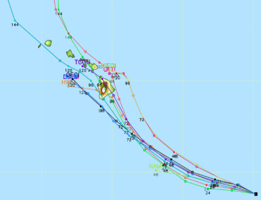
10/14 12Z EURO forecast for WED 10/22. Many models forecasting development.