10/19/24 - TS Oscar Forms Just East of The Turks and Caicos Islands

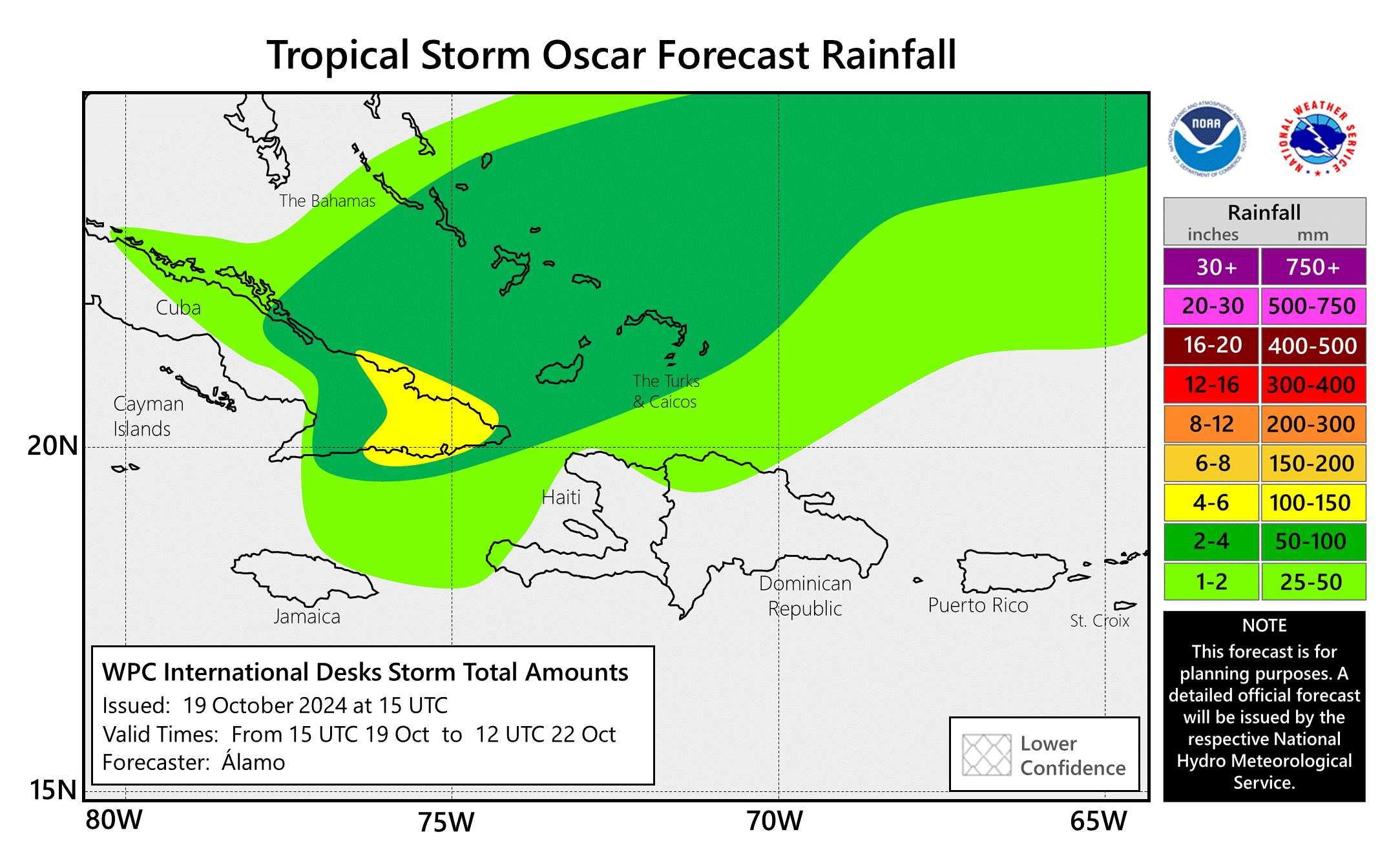
The 15th named storm of the season formed today just east of the Turks and Caicos Islands. Oscar is forecasted to remain a small tropical storm and only intensify slightly. The hurricane hunters have found winds of 70 mph and a special advisory will be issued by the NHC at 2 pm edt. Oscar will track slowly towards the northeast coast of Cuba and then turn northeastward and move out into the open Atlantic mid-week and possibly track near Bermuda. Tropical storm warnings are in effect for the southeastern Bahamas, the Turks/Caicos Islands and portions of northeast Cuba. Oscar will bring up to 2-6 inches of rain with locally higher amounts. Tropical Storm Nadine has made landfall in Belize and will fizzle out over the next 24 hours.

10/9/24 - Milton On Final Approach To Florida

Hurricane Milton is nearing the west coast of Florida this afternoon as a major category 3 hurricane. Winds have come down some as expected as the storm began encountering some southwesterly wind shear earlier today. Even though some weakening has occurred, big impacts remain and have been ongoing across parts of Florida today. The wind field has grown larger in size as well. Milton has spawned several tornadoes across central Florida today. Storm surge is beginning the coast and is expected to rise 6-13 feet near and just south of Tampa. Up to a foot or more of rain will fall along the track, mainly north of the center. Hurricane force winds will arrive at the coast later this evening and spread west to east across central Florida. We hope everyone is the path has taken proper precautions to protect life and property. We hope everyone stays safe tonight. Thanks for trusting Hurricane Tracker App to keep you updated on Milton.

please check the current storms tab > milton for all the latest graphics and advisories.

If you are not already a premium graphics subscriber, sign up today and get higher-resolution storm graphics that contain more information so you can make informed decisions. It also helps support our app since we now offer it free. We want to be around for a long time!

Premium users will also have access to wind graphics that the NHC does not publish. Details & sign up here > Premium Graphics Info.

Thank you for being a Hurricane Tracker App user and supporting our passion for tracking tropical cyclones!

10/8/24 - Major Hurricane Milton Headed To Florida

After weakening some last night due to an eye-wall replacement cycle, Milton has intensified once again and regained high-end Category 5 status with 165 mph winds. Upon approach to Florida on Wednesday, Milton is expected to interact with some upper-level wind shear and that should cause some slight weakening but not enough to knock it below major hurricane status. Milton’s wind field is also expected to double in size and damaging winds, life-threatening storm surge, and heavy rainfall will extend well outside the forecast cone. This is a very serious situation and residents in Florida should closely follow orders from their local emergency management officials. Evacuations and other preparations should be completed today. Milton has the potential to be one of the most destructive hurricanes on record for west-central Florida. please check the current storms tab > milton for all the latest graphics and advisories

We will have a new push alert update after the Wednesday 5 PM EDT NHC Advisory.

If you are not already a premium graphics subscriber, sign up today and get higher-resolution storm graphics that contain more information so you can make informed decisions. It also helps support our app since we now offer it free. We want to be around for a long time!

Premium users will also have access to wind graphics that the NHC does not publish. Details & sign up here > Premium Graphics Info.

Thank you for being a Hurricane Tracker App user and supporting our passion for tracking tropical cyclones!