
EL Nino Is Quickly Collapsing
We have already posted forecasts from AccuWeather and Colorado State University which both predicted an extremely active 2024 Atlantic Hurricane season with over 20 tropical cyclones. The two main factors causing forecasters to issue high numbers is because the Atlantic Ocean is already seeing water temperatures at July levels and a La Nina is forecasted over the eastern Pacific which leads to reduced wind shear in the Atlantic, allowing more storms to form. We already have the data to prove the Atlantic is very warm, but what is the status on La Niña? We will also discuss if we typically see more hurricanes in the Gulf during La Niña years.

Back in February, El Niño was in full force across the central and eastern Pacific near the equator with water temps running 2°C+ above average.

Two months later (April 2024), sea surface temperatures have dramatically reversed and temps are near normal to slightly below average in the same region. This will have important ramifications on the upcoming hurricane season.
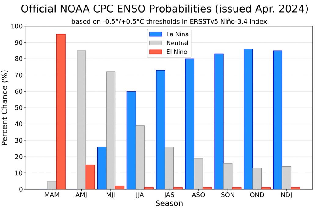
NOAA is forecasting over a 70% chance of La Niña by July/August/Sept (the heart of the hurricane season). No reason this will not verify given how quickly we are seeing the reversal of sea surface temperatures in the eastern Pacific. (NOAA Graphic).

During a La Niña, the Atlantic basin typically seas more frequent tropical cyclones and overall, they are stronger due to less wind shear. We may see less activity for the eastern Pacific basin this season. (AccuWeather graphic)

It’s easy to see in the image above (top right image above) that there are way fewer Gulf of Mexico hurricanes during and El Niño as compared to La Niña seasons (bottom left image above).
At this point in time, there’s no reason to go against the forecasts that have already been released predicting a very active season. In about a month, NOAA will release their 2024 Atlantic hurricane season forecast and we will see if it’s in line with the others issued before it. While we do not know exactly where storms will form and track this season, we have enough data to at least warrant a note to our users that preparation is the best defense against an active hurricane season. It’s never to early to begin preparing for what this season may bring. We will be here with you every step of the way and if the current state of the upcoming season changes, we will let you know. Thanks for following along and consider becoming a premium user (if no already) to help support this app and what we do. Thanks and have a great weekend!
The season will officially kick off on June 1st for the Atlantic and May 15th for the Eastern Pacific. If you are not already a premium graphics subscriber, sign up today and get higher resolution storm graphics that contain more information so you can make informed decisions. Premium users will have access to wind graphics that the NHC does not publish. Details here > Premium Graphics Info.
Thank you for being a Hurricane Tracker App user and supporting our passion for tracking tropical cyclones!

Our premium tier gives users access to all important wind swath charts for storms that may make landfall.