THU 9/26/24 - Hurricane Helene Discussion
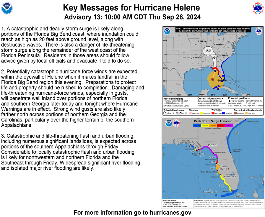
Summary: Hurricane Helene is getting stronger and has become a Category 3 hurricane with winds of 120 mph. It will strengthen further before making landfall in Florida tonight. The wind field is also expanding. Tropical storm force winds extend out over 340 miles to the east of the center.
Watches & Warnings: A full range of watches and warnings are in effect for portions of Florida and the interior southeast, which includes hurricane warnings, tropical storm warnings & a storm surge warning. Please see the graphic and text below for a full listing of watches and warnings that are currently in effect.
Track: Helene is tracking NNE pretty quickly around 16 mph and is not expected to stall or slow down as it approaches land. An upper low over the mid-south is helping to pull it NNE and a building high to its east will push it west into western Tennessee.
Intensity: The environmental and oceanic conditions across the eastern Gulf of Mexico remain favorable for the cyclone to intensify. It is forecasted to become a category 3 storm later today. Slight chance it will reach category 4, but it’s moving relatively quickly and may not have enough time over water to reach cat 4 status.
Rain Threat: Helene is expected to produce rainfall totals of 6 to 12 inches, with maximum rainfall totals up to 18 inches across portions of the southern Appalachian mountains through Saturday. This rainfall will likely result in areas of locally considerable flash and urban flooding, with river flooding expected. Heavy, rainfall and flash flooding will be one of the biggest threats with the system.
Wind Threat: Hurricane conditions are possible in the hurricane warning area by tonight, with tropical storm conditions already occurring across portions of the Florida peninsula. Tropical storm and hurricane conditions are expected to spread northward over the warning areas throughout today and tonight. Tonight, winds near Tallahassee may gust 100-120 mph where it comes ashore. Hurricane and tropical storm force winds will reach into middle and northern GA late tonight and into the day on Friday. Tropical storm conditions are possible in portions of SC and NC on Friday as well.
Storm Surge Threat: Storm surge will be catastrophic near and to the right of the center, up to 20 feet. View the storm surge graphic below.
Tornado Threat: Tornadoes are possible to the east and northeast of the center across the FL Peninsula, GA, SC and NC through Friday enight.
Recap: Helene will unfortunately be a major, destructive hurricane and we urge anyone in its path to use the last few hours to prepare for extended power outages, flash flooding, wind damage, and storm surge at the coast. Helene is a large hurricane and ts force winds will reach well beyond the center.
Thank you for trusting and using the Hurricane Tracker App. We appreciate you, and please stay safe if you're along the path of the system.
Go Premium: If you are not already a premium graphics subscriber, sign up today and get higher-resolution storm graphics that contain more information such as cities & counties so you can make informed decisions. It also helps support our app since we now offer it free. We want to be around for a long time!
Premium users will also have access to wind swath graphics that the NHC does not publish. Details & sign up here > Premium Graphics Info.
Thank you for being a Hurricane Tracker App user and supporting our passion for tracking tropical cyclones!
*Above is the latest push notification sent by the app. For current and up to date storm information including advisories and graphics, always click on the storm name under the “Current Storms” tab below. This section is not mean’t to show the latest storm information, just the latest notification we’ve sent. Thanks.


