SAT 8/3/24 - TS Debby Discussion
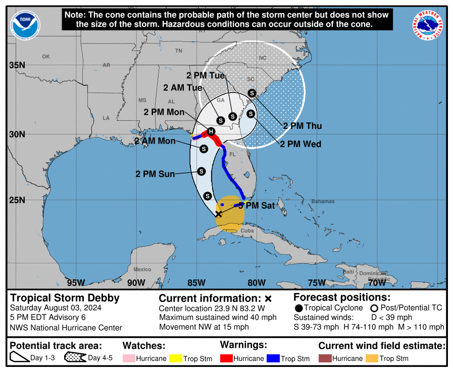
Summary: Newly formed TS Debby has become better organized today and is expected to become Hurricane Debby this weekend in the eastern Gulf of Mexico. The circulation is much better organized vs this time yesterday. The system is located over extreme SE Gulf of Mexico and is now moving towards the northwest. A turn to the north is expected later this weekend. As of this writing, max sustained winds are near 40 mph.
Watches & Warnings: A full range of watches and warnings are in effect for portions of Florida, which include a hurricane warning, a tropical storm watch, a storm surge watch, a storm surge warning, and a tropical storm warning. Please see the graphic and text below for a full listing of watches and warnings that are currently in effect.
Track: A large mid to upper level trough over the central United States is creating a break in the sub-tropical ridge and the cyclone is expected to turn northward in about 24 hours. This should be followed by gradual turn towards the northeast early this upcoming week. After a Florida landfall, weakening currents should cause the cyclone to slow down while it moves northeast over parts of northern Florida and Georgia. There is uncertainty in the forecast after 3 days as the cyclone interacts with a portion of the trough. The American and European forecast models move the system into the Atlantic and then turn it towards the southeast coast in about five days. The Canadian model moves the cyclone slowly northeast across the southeastern United States and does not bring it back over the Atlantic. Overall, the track forecast is a lot slower than previous advisories and after three days, the forecast track confidence is low. The slow forward speed early next week should allow for the cyclone to dump copious amounts of rainfall along its path.
Intensity: The environmental and oceanic conditions across the eastern Gulf of Mexico remain favorable for the cyclone to intensify. Initial intensification is likely to be slow. However, a faster rate of development is likely once the system gets better organized, and the cyclone is likely to be near or at hurricane strength when it reaches the northern Gulf Coast. It is expected to weaken as it crosses Florida into Georgia. Beyond 72 hours, the intensity forecast is highly uncertain as it will be dependent on whether or not the center circulation moves back over the Atlantic. If it remains over land, it will likely stay weak. If the cyclone moves into the open Atlantic Waters, it could be at hurricane status, and category one or two strength could be expected. High uncertainty with the intensity forecast beyond three days.
Rain Threat: Debby is expected to produce rainfall totals of 6 to 12 inches, with maximum rainfall totals up to 18 inches across portions of Florida and along the southeast United States coast this weekend through Thursday morning. This rainfall will likely result in areas of locally considerable flash and urban flooding, with river flooding expected. Heavy, rainfall and flash flooding will be the biggest threat with the system.
Wind Threat: Hurricane conditions are possible in the hurricane watch area by Sunday night, with tropical storm conditions possible earlier on Sunday. Tropical storm conditions are expected to spread northward over the warning areas beginning later today and continuing through Sunday. Tropical storm conditions are possible in the watch area in the Florida Keys later today or tonight, and in the Florida Panhandle by late Sunday. Wind gusts to tropical storm force are currently occurring over the Florida Keys.
Storm Surge Threat: Storm surge will range anywhere from 1’ to 7’ feet along portions of the western Florida Peninsula. The combination of storm surge and high tide will cause normally dry areas near the coast to be flooded by rising waters, moving inland from the shoreline.
Tornado Threat: a tornado or two is possible across the Florida Keys in the western Florida Peninsula tonight through Sunday morning. This threat will expand across northern and central FL on Sunday.
Recap: While at this time, this system is not expected to be a major hurricane by any means, it is going to cause some impacts along and near its track. Heavy rainfall and storm surge will likely be the biggest threats from the system. If you are along the predicted path, please take the appropriate action to keep your family and property safe. Also, check on your loved ones and your pets. We are not expecting any huge surprises with the storm, but it could become a hurricane before making landfall in Florida. At this point, a category 1 or two would be most likely. We will have another discussion posted sometime Sunday afternoon or evening.
Thank you for trusting and using the Hurricane Tracker App. We appreciate you, and please stay safe if you're along the path of the system.
Go Premium: If you are not already a premium graphics subscriber, sign up today and get higher-resolution storm graphics that contain more information such as cities & counties so you can make informed decisions. It also helps support our app since we now offer it free. We want to be around for a long time!
Premium users will also have access to wind swath graphics that the NHC does not publish. Details & sign up here > Premium Graphics Info.
Thank you for being a Hurricane Tracker App user and supporting our passion for tracking tropical cyclones!


