
7/6/24 10AM CDT - Beryl Headed For The Middle Texas Coast
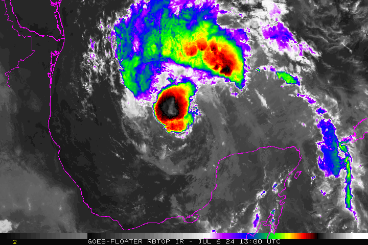
Beryl remains a tropical storm today with winds near 60 mph. However, this morning Hurricane Hunter and satellite data reveals the storm is trying to re-organize as new showers and thunderstorms are building near the center of circulation and the pressure is beginning to drop once again. The current forecast from the NHC shows the storm may strengthen to an 85 mph category one hurricane prior to landfall along the middle Texas coast on Monday morning.
A hurricane watch is in effect from the mouth of the Rio Grande River to San Luis Pass, Texas and a storm surge watch is in effect from the mouth of the Rio Grande river north to High Island.

It appears the eastward shift in the models has come to an end, and they are in much better agreement that the hurricane will make landfall somewhere near Port O'Connor Texas. This track would bring tropical storm force winds, and several inches of rain to the Houston and southeast Texas area. 6-8 inches+ of rain are expected along in east of the track. Storm Surge rise could also be up to 5 feet near where the center makes landfall.

The storm is going to be encountering some moderate wind shear due to an upper level low to its west and some possible dry air intrusions the next 12 to 24 hours. However, we do expect a strengthening storm upon approach to the Texas coast Sunday evening into Monday morning. At this time, it appears there's not going to be enough time for the system to become a major hurricane once again and winds should peak near 80 to 90 mph.

If you are in the cone or along the track, pay close attention to the official forecast from the NHC and listen to any emergency management officials in your local area. We will have another update as conditions warrant thank you for using the Hurricane Tracker App.
If you are not already a premium graphics subscriber, sign up today and get higher-resolution storm graphics that contain more information so you can make informed decisions. It also helps support our app since we now offer it free. Premium users will have access to wind graphics that the NHC does not publish. Details & sign up here > Premium Graphics Info.
Thank you for being a Hurricane Tracker App user and supporting our passion for tracking tropical cyclones!

Beryl wind swath graphic from our premium graphics.