
9/7/17 - Irma Poised To Bring Devastation To The Bahamas & The United States.
Overview: Hurricane Irma made landfall on several of the northeastern Caribbean Islands Wednesday, causing catastrophic devastation. Irma will continue tracking to the west-northwest during the next 2 days bringing hurricane conditions to the Turks/Caicos & the Bahamas. This weekend Irma is forecasted to make a northerly turn. When that turn occurs will determine what exact impacts Irma will have on Florida and the rest of the southeast United States. Hurricane watches are expected to be issued for the FL Keys & portions of the Florida peninsula later this morning. TAKE THIS HURRICANE SERIOUSLY IF YOU ARE ALONG THE PATH.

Watches/Warnings: A Hurricane Warning is in effect for Dominican Republic from Cabo Engano to the northern border with Haiti, Haiti from the northern border with the Dominican Republic to Le Mole St. Nicholas, Southeastern Bahamas, the Turks and Caicos Islands, Central Bahamas, and Northwestern Bahamas. A Hurricane Watch is in effect for Cuba from Matanzas province eastward to Guantanamo province. A Tropical Storm Warning is in effect for Dominican Republic from south of Cabo Engano westward to the southern border with Haiti, Haiti from south of Le Mole St. Nicholas to Port-Au-Prince, Cuba provinces of Guantanamo, Holguin, and Las Tunas.

Intensity: Irma has now had winds of at least 180 mph for 42 hours straight (as of 5AM Thursday). That breaks the previous record that Hurricane Allen broke in 1980 of 18 hours. It is forecast to remain as a category 5 hurricane through at least Friday. If she makes landfall on South Florida, then the potential is there that it does so as a category 5 storm. At this moment, the National Hurricane Center forecast has a 150 mph category 4 hurricane possibly make landfall in that region, but with very warm oceans we wouldn’t be surprised if it ends up being stronger than the current forecast.

Track (Short-Term): The certainty remains high the next couple days in regards to where Hurricane Irma is headed. Today, the Dominican Republic and Haiti can expect tropical-storm-force winds and showers as the storm passes less than 100 miles to the north. It will continue to move west-northwest, getting very close, if not make landfall on Turks and Caicos tonight as a category 5 storm. It will then impact the southern Bahamian islands where hurricane-force winds and heavy rain are expected on Friday and Friday night. Cuba will also likely get some of the outer rainbands with gusty winds Friday into Saturday.
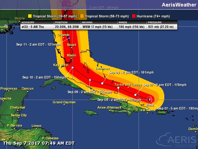
Wind band forecast based off the 5AM NHC advisory.
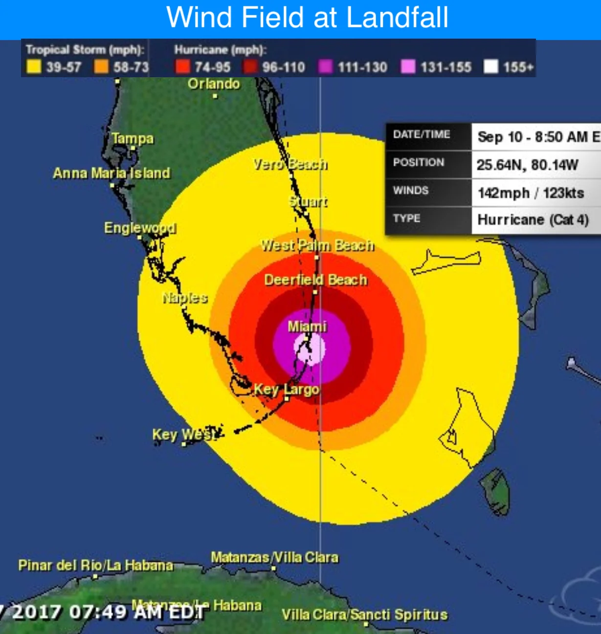
The forecasted wind field at landfall based on the 5AM NHC track shows potentially catastrophic winds > than 130 mph in the Miami area. Hurricane force winds will likely effect much of south FL. There is no getting around the fact that this would be devastating for S FL is this forecast verifies.
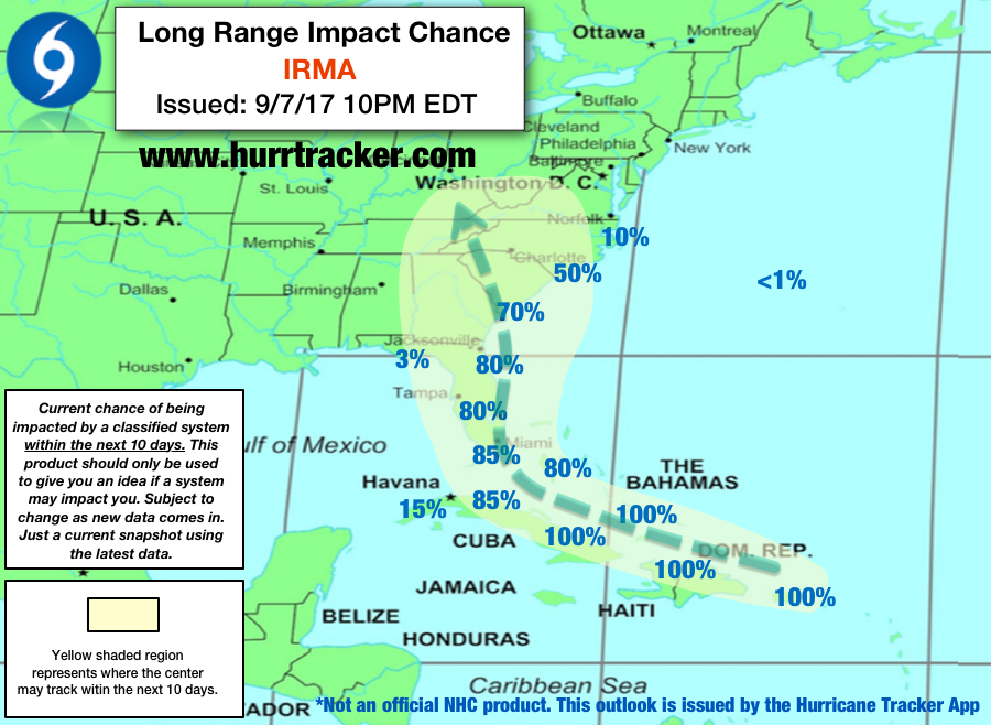
Track (Long-Term): The uncertainty in Irma's track increases some by this weekend. The question is when does the turn to the north occur. If it happens early, it will remain off the eastern coast of Florida but will still bring tropical storm conditions. By keeping the storm over the warm waters, however, this will allow it to maintain its strength and can quite possibly make landfall in the Carolinas. Now if the storm makes a landfall on South Florida, like what many of the models have been honing in on, much of South and Central Florida can expect torrential rain and hurricane-force winds in excess of 100 mph. This would be the worse case scenario. What’s especially concerning about this is that the models that take this track then take it back over the ocean after passing through the Miami area. Furthermore, it may re-strengthen before making a second U.S. landfall on South Carolina. There is still the small chance Irma turns north late in the game and moves into the eastern Gulf of Mexico and affect and western coast of Florida and the Panhandle, but the main focus is on the two scenarios just mentioned. If you are in Florida, Georgia, South Carolina, or North Carolina, you need to be preparing, especially if you are by the coast. Also monitor the forecast and evacuate if you are told to do so by your local officials. At this point in time, focus on the cone and not the exact track.
Alert Levels: We have issued “High” Alert Levels for South, Central, and northeastern Florida. We have also issued Alert Levels for Georgia and the Carolinas. Please review our key below for recommended actions to take based on the alert level issued for your area.


Conclusion: Hurricane Irma is a catastrophic hurricane that you have to prepare for if you are in it’s path. If this storm makes landfall on the Miami, FL area, there is the potential this storm could be worse than Hurricane Andrew.
We will have another update on Hurricane Irma as conditions warrant. Thanks for using our service.
-Jackson Dill, Hurricane Tracker App Team