
Hurricane Warnings Issued Along Matthew's Track. A U.S. Threat Cannot Be Ruled Out
Matthew is a major hurricane. Check the storm page under "Current Storms" for all the latest information, maps & advisories. Information there is updated in real time. This section is not meant to provide real time information. This is where we post our analysis each evening. We will have a new detailed discussion on Matthew later on Sunday evening. Please see our most recent discussion issued Saturday night below:
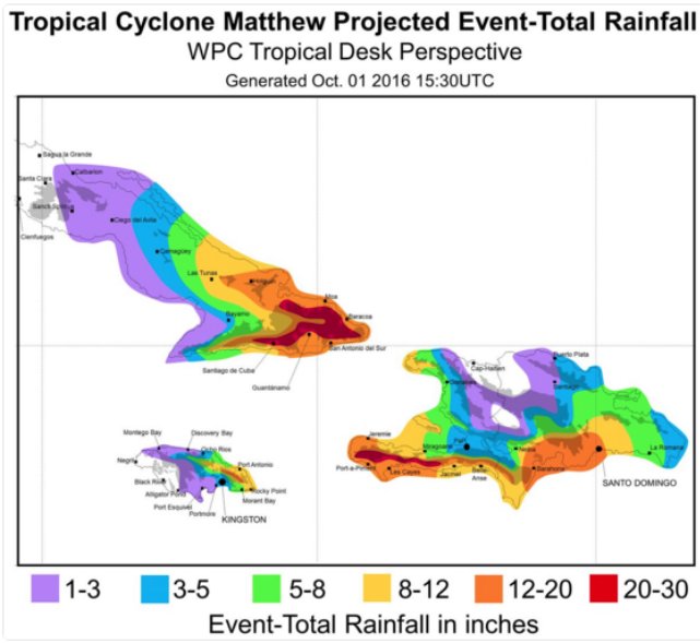
A hurricane warning has been issued for Jamaica & Haiti & Eastern Cuba. We are very concerned about major impacts in Jamaica/Haiti on Monday and eastern Cuba on Tuesday.
If you would like to receive these updates the moment they are published, please click here to sign up for email updates.

All indications are that Matthew will remain a dangerous major hurricane over the next few days. We will likely see fluctuations with intensity, but overall Matthew should remain a category 3+ hurricane. After Matthew passes Jamaica and Haiti, Matthew will move over eastern Cuba and into the Bahamas by midweek. Matthew may weaken by a category or two over Cuba, but environment conditions appear to be near perfect in the Bahamas for Matthew to re-strengthen. Please do not take the storm lightly if you are in its path. Sustained winds may be well over 100 mph close to the center and flooding rains are likely in portions of these regions. Rainfall amounts may approach 20+ inches along its path.


Beyond the Bahamas, it appears likely Matthew will turn towards the northwest and generally head towards the southeastern United States as a ridge of high-pressure builds to its north and east. How far Matthew gets to the coast is the big question. A trough of low pressure will be moving across the United States next week and if Matthew’s track slow enough it could get picked up by the trough and turned out into the open Atlantic. However, the trough of low pressure is not guaranteed to turn Matthew away as some of the latest model runs have been trending weaker with the trough of low pressure. The steering pattern that is setting up is still very complicated and the models have not converged on a final track yet for Matthew. Lots of moving parts. We probably won't have a model consensus on the final track for another 2-3 days.

Does the forecasted trough of low pressure get to Matthew in time to turn it away from the coast? All about timing.
We will be here over the next several days to keep you updated. We usually try to issue these discussions at the end of the day once all the model data has been reviewed. We will also issue audio and video updates as necessary. For those of you in the path of Matthew, it's time to plan and prepare and for those of you along the east coast of United States, let's just continue watching what happens as we have plenty of time before any potential impact.
Follow our Twitter feed @hurrtrackerapp for more detailed and frequent updates on the models and real time data.