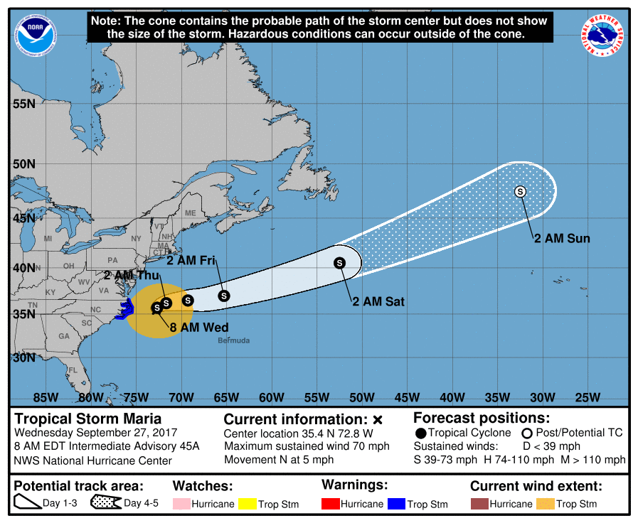
9/27/17 - Maria Moving Out to Sea & Lee Could Become Our 5th Major Hurricane

The tropics are finally beginning to quiet down a bit as Maria gradually begins to weakens and pulls away from the United States coast. However, there is still Hurricane Lee in the Atlantic, but Lee will not impact any land.

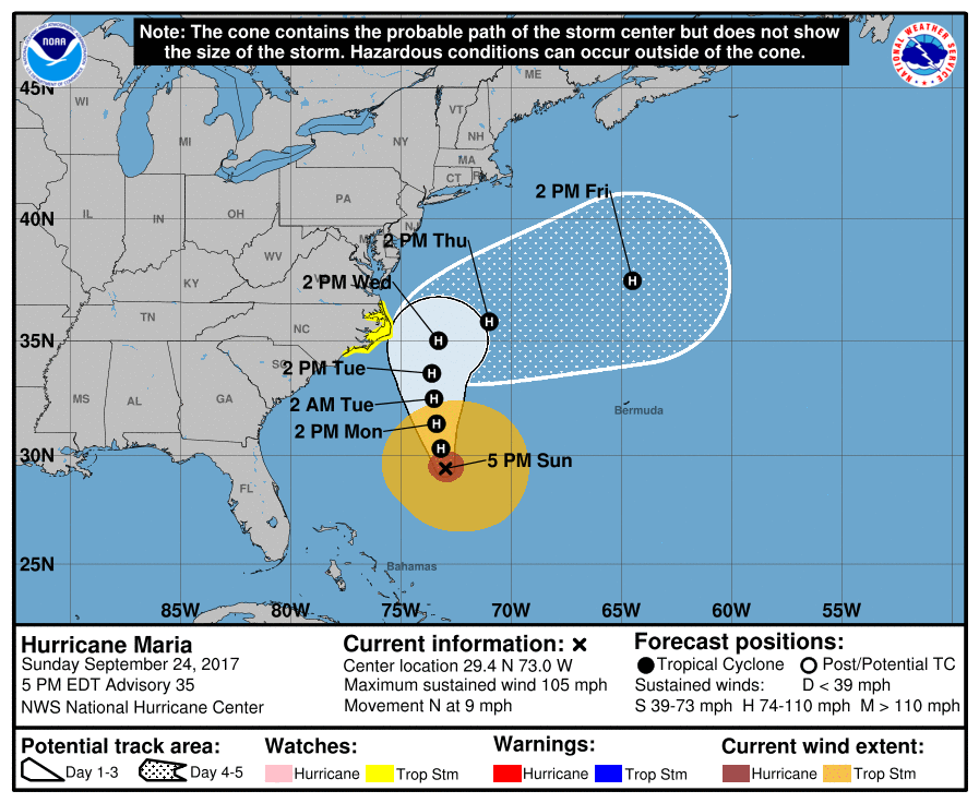
Tropical Storm Maria:

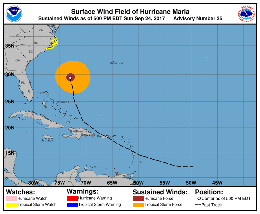
Forecast: Maria will continue to bring some showers to the Outer Banks of North Carolina today. That rain may add up to an inch. Gusty winds will also remain present. The highest winds will be in the Cape Hatteras area with gusts as high as 50-60 mph. The third ongoing threat is storm surge with 2-4 feet of inundation forecast. Cape Hatteras did record between two and three feet of surge on Tuesday. Starting tonight, Maria will begin to slowly turn east as a trough approaching from the west picks her up. Then by Friday, she will move very quickly out to sea while moving away from land.

091533_5day_cone_no_line_and_wind.png

Hurricane Lee:


Lee has the potential to become the fifth major hurricane of the Atlantic season today. It is currently a 110 mph storm over the central Atlantic, and the National Hurricane Center holds it at that strength today. We still think there is the chance winds get up to 115 mph, which would make it a major hurricane. The good news is that Lee is no threat to the U.S. or any area of land. Later this week, it will get picked up by the jet stream, taking a similar fast-moving path like Maria.

084142_5day_cone_no_line_and_wind.png

Tropical Outlook:

There are no new areas to watch within the next five days in the Atlantic basin, but beyond that point looking ahead to early October, the models have been honing in and continue to focus on possible tropical development in the western Caribbean. The waters in this part of the ocean are so warm, containing significantly higher heat potential than during the notorious 2005 hurricane season. These warm waters are definitely concerning if a tropical cyclone forms over it because it can allow it to rapidly intensity, of course if all the other conditions are conducive, such as low wind shear. Currently, the EURO ensembles show up to a 70% chance for a tropical depression to form over the western Caribbean in about 7-9 days.

Image from Tweetbot.jpg

We will have another update as conditions warrant. Thank you for using our service and application.


-- Jackson Dill, Hurricane Tracker Team 

9/24/17 - TS Watches Issued For Portions of NC

The tropics still remain very active with two hurricanes currently spinning in the Atlantic: Maria and Lee. TS & storm surge watches have been issued for a portion of the North Carolina coastline in anticipation of some impacts from Maria mid-week.

Hurricane Maria:
Maria is down to a category 2 hurricane as it moves up the East Coast of the United States hundreds of miles offshore. It will bring elevated surf and a high rip current risk to the entire East Coast during most of the new week. During the next couple days, Maria will still be far off the coast, but by Wednesday it will make its closest approach. The Outer Banks need to monitor this storm. In fact, tropical storm watches have been issued for a portion of the NC coast (see below).  At this time, we think the core of Maria will remain off the coast but it will still get fairly close enough for some impacts to occur. We think showers and gusty winds that will be tropical-storm-force (39+ mph) will affect the Outer Banks on Wednesday. There is also the concern for minor storm surge due to a northerly wind that will build up the water into the southern portions of the Pamlico Sound. Beyond Wednesday, Maria is forecast to take a sharp right turn as the jet stream picks her up and takes her out to sea. By then, we can finally stop tracking Maria.

Hurricane Lee:
Lee has rapidly strengthened into a hurricane. If you recall, Lee used to be a tropical storm over a week ago, then it dissipated, and now the National Hurricane Center began to reissue advisories on the storm earlier this week. The good news is that Lee will not impact land as it spins and meanders over the central Atlantic. It should remain a hurricane through at least Friday.

Tropical Outlook:
There are currently no areas to watch in the Atlantic within the next five days, besides Hurricanes Maria and Lee. Looking ahead to early October, there is the potential for a tropical system to start to develop in the western Caribbean. It’s still very early to start talking about this system, but the models have been honing in on this possible tropical entity. We’ll be tracking!


We will have another update as conditions warrant on Hurricanes Maria and Lee. Thank you for using our service and application.


-- Jackson Dill, Hurricane Tracker Team