9/26/24 - Major Hurricane Helene Intensifying On The Way To Florida

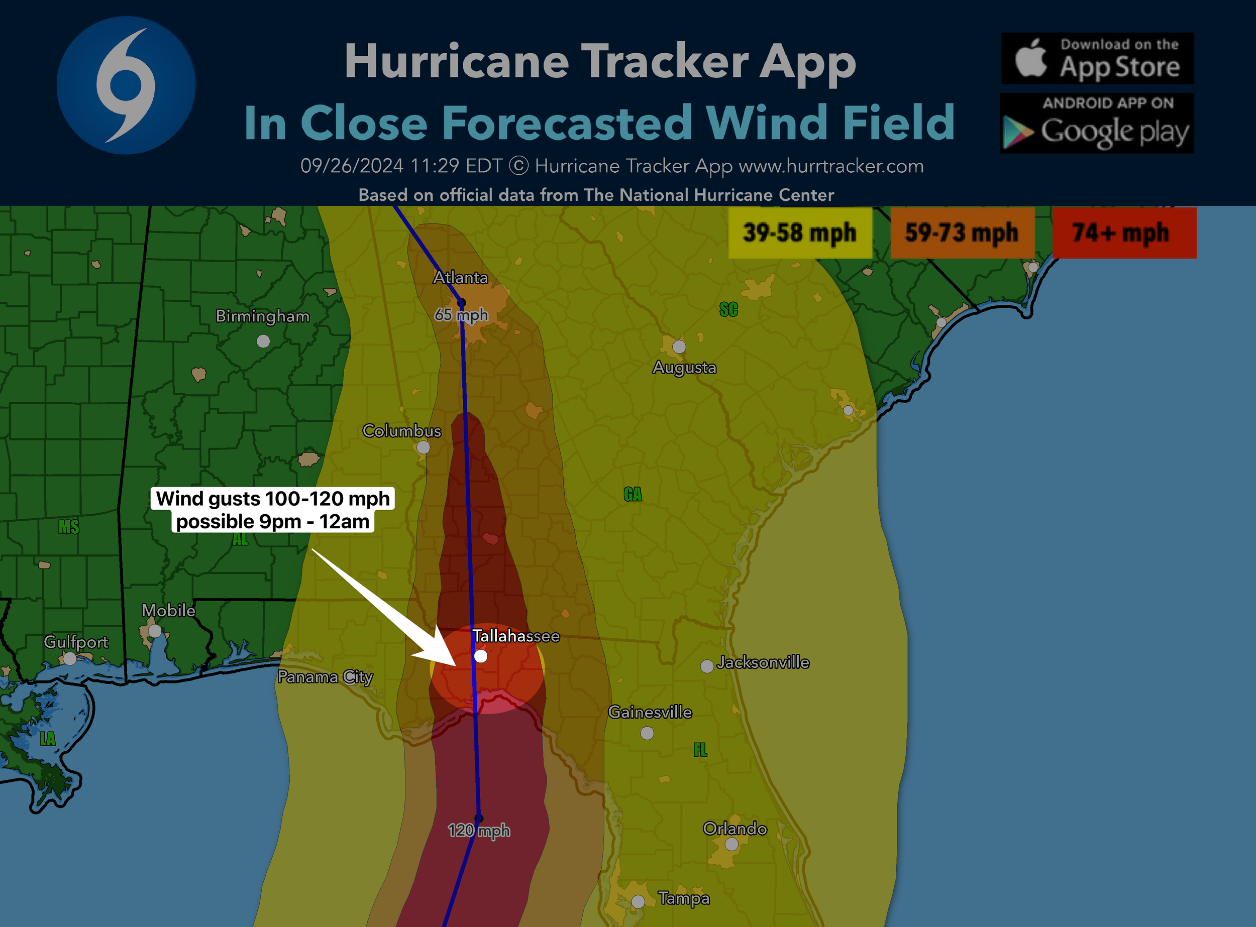
Hurricane Helene is NOW a Category 4 hurricane with winds of 140 mph. It’s tracking NNE towards the Big Bend coastline of Florida. It will continue to intensify up until landfall later this evening. Winds could reach 145 mph or even a little higher. The TAYLOR COUNTY area appears to be in line for a direct hit unless the hurricane wobbles upon approach. Storm surge will be catastrophic near and east of where the center makes landfall. Major impacts will be felt far inland into GA, TN, SC, NC. We expect millions will lose power, even well inland. Please stay safe if you’re in the path and listen to local officials.

Based on the current NHC track (it could change slightly east or west), we will likely see wind gusts 100 - 120+ mph tonight in the highlighted region where the eye-wall comes ashore later tonight. Be prepared for major wind damage and power outages.

Hurricane and tropical storm warnings extend well inland into the southeast U.S.

If you are not already a premium graphics subscriber, sign up today and get higher-resolution storm graphics that contain more information so you can make informed decisions. It also helps support our app since we now offer it free. We want to be around for a long time!

Premium users will also have access to wind graphics that the NHC does not publish. Details & sign up here > Premium Graphics Info.

Thank you for being a Hurricane Tracker App user and supporting our passion for tracking tropical cyclones!

9/25/24 - Helene Is Now a Hurricane

Helene is now a hurricane with winds of 80 mph. It's now forecasted to reach wind speeds of 125 mph before striking FL tomorrow night. Extremely dangerous situation unfolding and I hope everyone in the path listens to local officials and takes the proper steps to protect life and property.

If you are not already a premium graphics subscriber, sign up today and get higher-resolution storm graphics that contain more information so you can make informed decisions. It also helps support our app since we now offer it free. We want to be around for a long time!

Premium users will also have access to wind graphics that the NHC does not publish. Details & sign up here > Premium Graphics Info.

Thank you for being a Hurricane Tracker App user and supporting our passion for tracking tropical cyclones!

Downloaded Hurricane Tracker for FREE and love the app? Help support our server and bandwidth fees. Your support is greatly appreciated and helps us keep providing this service year after year! Donate any amount here.