9/10/24 - Francine Headed To The Northern Gulf Coast

Francine remains a tropical storm, but is expected to become a hurricane later today. Winds are forecasted to peak near 90 mph prior to landfall in Louisiana Wednesday evening. There are numerous watches and warnings that have been issued for portions of the Louisiana, Alabama and Texas coastlines and adjacent inland areas. Life-threatening hurricane force winds and storm surge is expected in the hurricane and storm surge warning areas. The most recent models have been shifting east some. Interests in SE Louisiana, including New Orleans, along with coastal Mississippi and Alabama should monitor the progress or Francine closely as more EASTERLY shifts in the track are possible.

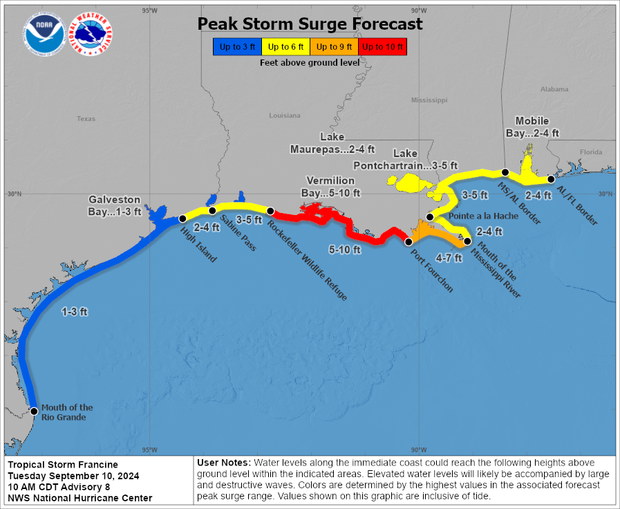
Catastrophic storm surge up to 10 feet is expected along the central Louisiana coastline.

Wind swath graphic updated every 6 hours for premium subscribers as new data from the NHC comes in.

If you are not already a premium graphics subscriber, sign up today and get higher-resolution storm graphics that contain more information so you can make informed decisions. It also helps support our app since we now offer it free. We want to be around for a long time!

Premium users will also have access to wind graphics that the NHC does not publish. Details & sign up here > Premium Graphics Info.

Thank you for being a Hurricane Tracker App user and supporting our passion for tracking tropical cyclones!

9/9/24 - Francine Quickly Becoming Better Organized

A Hurricane Warning has been issued for the Louisiana Coast from Sabine Pass to Morgan City. Francine now has winds of 65 mph and is quickly becoming better organized. The official forecast is calling for a category 2 landfall with winds near 100 mph. Storm surge warnings also in effect for surge up to 10 feet near where the center makes landfall. Tropical storm warnings and watches are also in affect for other portions of the western Gulf. See below.

If you are not already a premium graphics subscriber, sign up today and get higher-resolution storm graphics that contain more information so you can make informed decisions. It also helps support our app since we now offer it free. We want to be around for a long time!

Premium users will also have access to wind graphics that the NHC does not publish. Details & sign up here > Premium Graphics Info.

Thank you for being a Hurricane Tracker App user and supporting our passion for tracking tropical cyclones!

Premium Graphics now includes INLAND watches and warnings as issued by the National Hurricane Center. Updates every 6 hours with each advisory.

9/9/24 - TS Francine Forms In The Gulf of Mexico

Tropical Storm Francine has formed in the Gulf of Mexico with winds near 50 mph. It’s expected to become a hurricane on Tuesday and make landfall along the coast of Louisiana Wednesday evening as a hurricane with winds near 85 mph. A hurricane, tropical storm and storm surge watch is now in effect.

If you are not already a premium graphics subscriber, sign up today and get higher-resolution storm graphics that contain more information so you can make informed decisions. It also helps support our app since we now offer it free. We want to be around for a long time!

Premium users will also have access to wind graphics that the NHC does not publish. Details & sign up here > Premium Graphics Info.

Thank you for being a Hurricane Tracker App user and supporting our passion for tracking tropical cyclones!