Zeta Takes Aim at Southeastern Louisiana; Landfall Expected Tomorrow Evening
After weakening a bit due to interaction with the Yucatan Peninsula this morning, Zeta is back out over the Gulf of Mexico and is beginning to restrengthen.

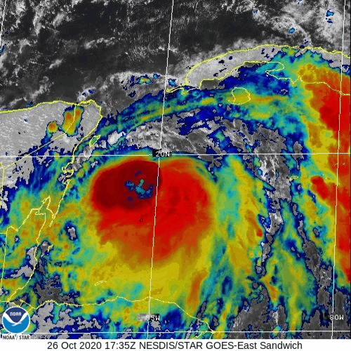
Satellite imagery just before sunset showed numerous intense convective towers wrapping almost entirely around the storm’s center. This is important because if the ring of thunderstorms can manage to close off, we could see a burst of fairly quick intensification tonight into tomorrow morning. If it remains open, intensification will be considerably more modest. In either case, Zeta is expected to become a hurricane again sometime tonight or tomorrow morning.

Zeta is expected to curve north and eventually northwest tonight/tomorrow before making landfall in southeastern Louisiana while moving rapidly northeast tomorrow evening. The worst of the storm will be along and just east (within 25-35 miles) of the center’s path. In this area, winds in excess of 75 mph are expected along with significant storm surge along the shorelines (>5 feet possible in some spots) Because Zeta will be moving so quickly, the storm’s strong winds will persist well inland into parts of southern Mississippi and western/central Alabama as well as NW Georgia. Folks in these regions should be prepared for power outages even though they are relatively far from the region where the storm’s maximum winds will come ashore.
The bright side to Zeta’s fast forward motion is a decrease in the heavy rain threat. While flash flooding will occur as 3-6” of rain falls in a relatively short time, widespread major flooding is not expected. Heavy rain will also continue well inland as Zeta weakens on Thursday and places as far northeast as Virginia and Maryland could see flooding problems as Zeta’s moisture moves north.
-Jack
Issued: TUE 10/27/2020