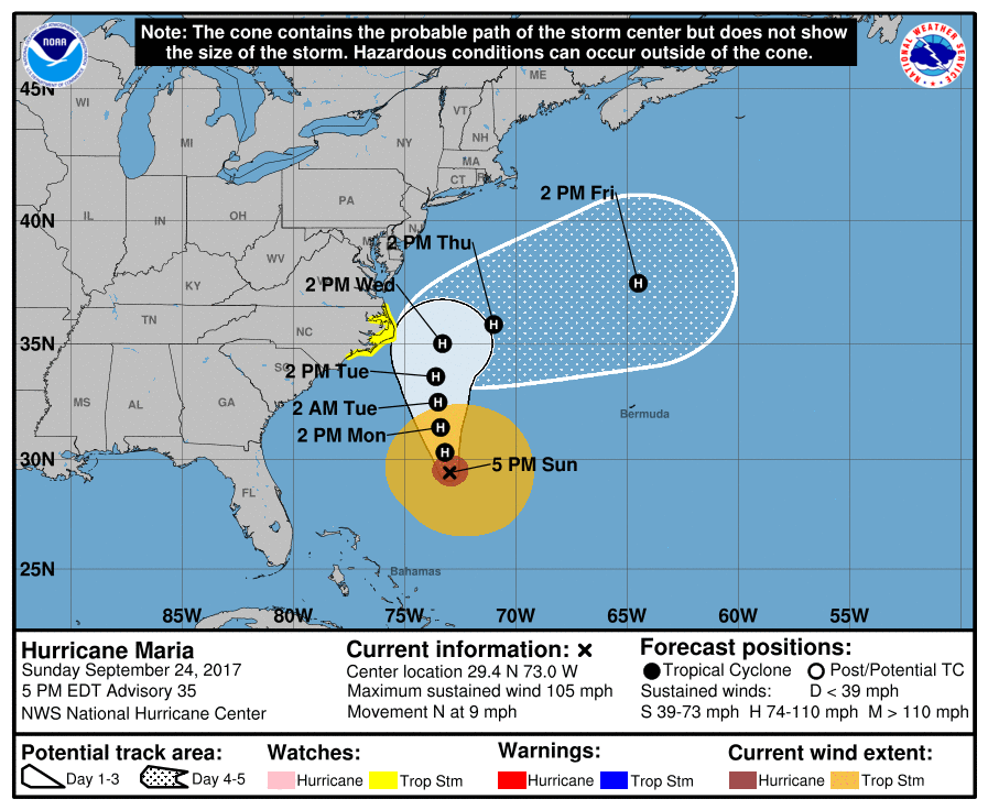
9/24/17 - TS Watches Issued For Portions of NC

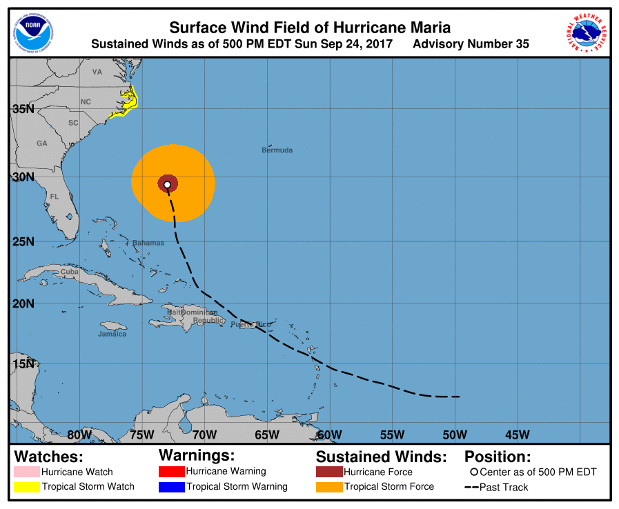
The tropics still remain very active with two hurricanes currently spinning in the Atlantic: Maria and Lee. TS & storm surge watches have been issued for a portion of the North Carolina coastline in anticipation of some impacts from Maria mid-week.

Hurricane Maria:
Maria is down to a category 2 hurricane as it moves up the East Coast of the United States hundreds of miles offshore. It will bring elevated surf and a high rip current risk to the entire East Coast during most of the new week. During the next couple days, Maria will still be far off the coast, but by Wednesday it will make its closest approach. The Outer Banks need to monitor this storm. In fact, tropical storm watches have been issued for a portion of the NC coast (see below).  At this time, we think the core of Maria will remain off the coast but it will still get fairly close enough for some impacts to occur. We think showers and gusty winds that will be tropical-storm-force (39+ mph) will affect the Outer Banks on Wednesday. There is also the concern for minor storm surge due to a northerly wind that will build up the water into the southern portions of the Pamlico Sound. Beyond Wednesday, Maria is forecast to take a sharp right turn as the jet stream picks her up and takes her out to sea. By then, we can finally stop tracking Maria.

Hurricane Lee:
Lee has rapidly strengthened into a hurricane. If you recall, Lee used to be a tropical storm over a week ago, then it dissipated, and now the National Hurricane Center began to reissue advisories on the storm earlier this week. The good news is that Lee will not impact land as it spins and meanders over the central Atlantic. It should remain a hurricane through at least Friday.

Tropical Outlook:
There are currently no areas to watch in the Atlantic within the next five days, besides Hurricanes Maria and Lee. Looking ahead to early October, there is the potential for a tropical system to start to develop in the western Caribbean. It’s still very early to start talking about this system, but the models have been honing in on this possible tropical entity. We’ll be tracking!


We will have another update as conditions warrant on Hurricanes Maria and Lee. Thank you for using our service and application.


-- Jackson Dill, Hurricane Tracker Team 

9/21/19 - Jose To Linger & Maria Should Miss The United States East Coast

Note: At times, our team will write in-depth discussions on the tropics or systems below. Always visit the "Current Storms" section for the latest advisories and tracking maps on active systems.

We’re still tracking Tropical Storm Jose and Hurricane Maria. Jose has now been a named storm for 16 days. That makes it the eighth longest named storm on record!


Tropical Storm Jose: Jose has stalledl off the New England coast. It is currently about 150 miles southeast of Nantucket, MA. Winds are expected to gust there and along the Massachusetts coast up to 40-50 mph through the weekend as the storm just sits offshore. There will be some showers at times, but the general theme are the clouds and breezy conditions in southeastern New England. The main impacts through early next week as Jose gradually weakens will be the beach erosion due to the significant waves of up to ten feet pounding the coast. Tropical Storm Warnings remain in place for: Woods Hole to Sagamore Beach, including Cape Cod, Block Island, Martha's Vineyard, and Nantucket. The models have been trending towards the idea of Jose dissipating off the Northeast coast around Monday of next week. By then, we can finally say so long to Jose!

233807_5day_cone_no_line_and_wind.png

Hurricane Maria: We know everyone wants to know about Maria because it is a major hurricane and there is a slight chance it impacts the U.S. East Coast.

Short-Term Forecast: Maria re-strengthened over the water northwest of the Dominican Republic. Also, the eye of Hurricane Maria has significantly expanded in size compared to the pinhole eye it used to have before making landfall on Puerto Rico.

Maria will continue to bring rain and wind gusts up to hurricane-force to the northern coast of the Dominican Republic through tonight. Then, it will begin to steer northward, moving just east of Turks and Caicos on tomorrow. The eastern islands of Turks and Caicos will likely deal with hurricane-force winds in excess of 74 mph. There is even the possibility these islands take a hit from the western eyewall of Maria. Both the Turks and Caicos islands and the southeastern Bahamian islands can expect up to twelve feet of storm surge with waves up to fifteen feet tall. Significant damage is unfortunately possible for Turks and Caicos again after they got destroyed by Hurricane Irma less than two weeks ago.

Long-Term Forecast: In the long-term after Maria moves north of Turks and Caicos, it’s time for the U.S. East Coast to monitor this storm. At this time, we are able to rule out direct impacts for Florida and South Carolina, but from North Carolina through Maine and even the Canadian Maritimes, there is the chance for impacts. Maria will track somewhere between the Outer Banks of North Carolina and Bermuda on Tuesday. Around this time is when there is a small amount of uncertainty. None of the operational models, such as the European or American, take Maria into the coast, although a few of its ensembles do. We’re leaning towards the idea of Maria staying far enough offshore for minimal impacts as it tracks out to sea due to a trough, which is what the large majority of models show. Again, monitor the storm but we are currently forecasting Maria to not make landfall on the United States.

Latest European ensemble model runs only shows a few tracks towards the Mid-Atlantic 

Latest European ensemble model runs only shows a few tracks towards the Mid-Atlantic 

Tropical Outlook: The National Hurricane Center currently states there will no new tropical cyclone development in the next 5 days.

We will have another update as conditions warrant on Hurricanes Jose and Maria. Thank you for using our service and application.


-- Jackson Dill, Hurricane Tracker Team