9/20/17 - Latest Discussion on TS Jose & Hurricane Maria

Hurricane Maria has officially made landfall as a very strong, category 4 hurricane on Puerto Rico. There is no doubt there will be catastrophic damage on parts of the island. Meanwhile in New England, Tropical Storm Jose will brush the coast with some showers and strong winds. Nothing as nearly as bad as Maria.

Tropical Storm Jose:

Forecast: Jose has finally weakened into a tropical storm as it moves northeast, making its closest approach to southeastern New England. Jose will not make landfall, but will still bring showers to this portion of New England and wind gusts up to 50-60 mph on the islands of Massachusetts. This will likely cause some isolated-scattered  power outages in the area. As we track Jose into the weekend, it’s just going to linger around off the Northeast coast, gradually weakening with time and eventually becoming a post-tropical cyclone as the full effects of the cooler ocean water takes place. Rip currents and rough seas will continue for the next few days. 
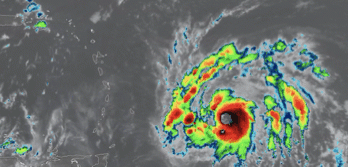
114742_5day_cone_no_line_and_wind.png

Hurricane Maria:


Short-Term Forecast: Hurricane Maria will continue to slam Puerto Rico as a major hurricane today as the storm moves northwest across the island. Rainfall totals will be as high as two feet, which will cause mudslides and may unfortunately take out some structures. Storm surge is also a concern on top of everything else with a general 6-9 feet of water level rise expected along the coast. Maria will emerge back over the Atlantic by this afternoon. Impacts will then begin for the Dominican Republic. Expect rain and strong wind--Gusts may reach hurricane-force, but thankfully the core will likely stay over the water. The Turks and Caicos and the southeastern Bahamian islands are up next for impacts from Maria Thursday night into Friday. This storm will still be a major hurricane, but weakening some. The current NHC track takes the center of Maria to the east of these islands, which is some good news because the northeastern quadrant of a hurricane is always contains the worst winds. However, these islands are in the cone so that means a direct landfall is still possible. If you are in the path of Maria, please rush all preparations to completion.

96lwind.png

Long-Range Forecast: In the long-term, the United States (North Carolina northward) will need to monitor Hurricane Maria. With a blocking high pressure over the Atlantic, steering these storms toward the U.S., this storm poses a risk to the Eastern Seaboard. At this time, we are leaning more towards an out-to-sea scenario, but the model guidance has shifted to the west and a bit closer to the U.S. There are different scenarios in which Maria may follow. If Jose dissipates or moves inland again, Maria may be pulled into the Northeast or Mid-Atlantic. If Jose continues to mill around off the coast, it will help to further weaken the ridge of high pressure, raising the chances that Maria would move safely out to sea. Please see our latest long range outlook below:
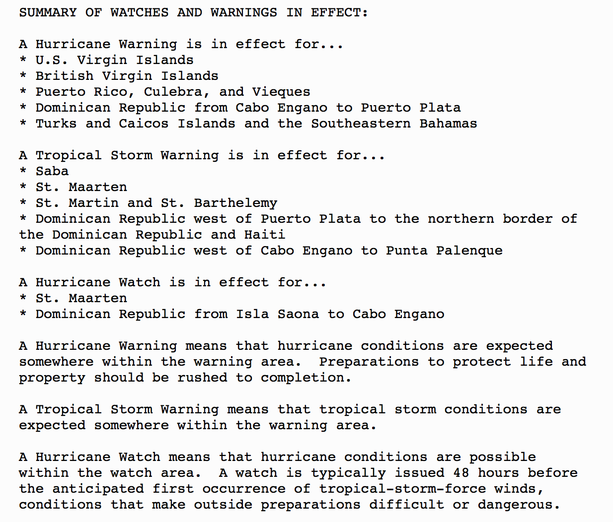
96llongrange.png

Alert Levels:

96lalertlevel.png
key.png

Tropical outlook: The remnants of Lee have a high chance of re-developing, but it will remain harmlessly out at sea. Finally, some model data is indicating that pressures may significantly lower in the western Caribbean in about 7-10 days, so of course we will be monitoring that part of the basin for development as we close out September.


We will have another update as conditions warrant on Hurricanes Jose and Maria. Thank you for using our service and application -- Jackson Dill, Hurricane Tracker Team 

9/18/17 - CAT 5 Maria Beginning To Impact The Caribbean While Jose Tracks Towards S New England

Note: At times, our team will write in-depth discussions on the tropics or systems below. Always visit the "Current Storms" section for the latest advisories and tracking maps on active systems.

Two storms in the Atlantic are about to impact two different areas of land. Hurricane Jose is headed for New England Tue/Wed, but won’t make landfall and Hurricane Maria is beginning to impact portions of the Lesser Antilles. 

Hurricane Jose: As the storm tracks toward cooler ocean waters and wind shear increases, it will gradually weaken as it begins to impact Southern New England Tuesday into Wednesday. The main threats associated with Jose will be the rain and the wind. Some locations, especially near Cape Cod may pick up around half a foot of rainfall. Winds may gust as high as 50-60 mph in southeastern Massachusetts. Those winds may cause scattered power outages, so make sure you are all stocked up on batteries water, non-perishables, gasoline for generators etc . Otherwise, the rest of Southern New England will get showers and gusts up to 20-40 mph. Also, some minor coastal flooding is possible with a storm surge up to one or two feet. By Thursday, the storm will begin to stall because there is no steering flow to bring it out to sea. Jose will likely sit off the Northeast coast as a weakening cyclone and become a remnant low by this weekend. Jose will likely cause a weakness in the steering flow allowing Maria to be pulled north likely away from the United States coast.

204920_5day_cone_no_line_and_wind.png

Current Watches/Warnings:

Hurricane Maria:

Short-Term Forecast: Hurricane Maria is the most concerning storm in the Atlantic at this time. The National Hurricane Center is forecasting Maria to make landfall on Puerto Rico on Wednesday as a category 4 or 5 hurricane. If that were to happen, the entire island would deal with catastrophic damage. Tonight, Maria will move through the Lesser Antilles, near Dominica, as a 160 mph category 5 hurricane. The good news, if there is any good news with this storm, is that the center of Maria will likely miss the northern Leeward Islands that were devastated by Hurricane Irma. Then on Wednesday, the brunt of the storm will move into the Virgin Islands and Puerto Rico. You need to prepare now. You only have until Tuesday evening to finish preparations! Later in the week, the Dominican Republic and Haiti will be impacted by rain and wind from Maria. It is not forecast to make landfall on Hispaniola, but they are in the NHC cone so it is definitely possible. As Maria passes near Hispaniola, the storm may take a more north-northwesterly direction instead of west-northwest. Either way, Turks and Caicos and the eastern Bahamian islands will likely be affected by Maria. Storm surge could be significant just like it was for Irma for these islands.

Maria went from an Invest to a CAT 5 hurricane in 48 hours.

Maria went from an Invest to a CAT 5 hurricane in 48 hours.

Current Watches/Warnings:
 

205325_5day_cone_no_line_and_wind-2.png

Long-Range Forecast: The latest guidance is showing that Maria should turn east of the United States and into the open Atlantic thanks to Hurricane Jose creating a south > north steering flow for Maria. If Jose was not sitting of the coast of New England, Maria would then likely track WNW towards the SE U.S. Of course, with this being a long range outlook and more than a week away, it could still change and we will closely monitor the latest data and let you know if there is any shift in the track towards the east coast.

Bottom Line.png

We will have another update as conditions warrant on Hurricanes Jose and Maria. -- Jackson Dill & Steve Parker, Hurricane Tracker Team