9/17/17 - The Latest On Hurricane Jose & Hurricane Maria

Note: At times, our team will write in-depth discussions on the tropics or systems below. Always visit the "Current Storms" section for the latest advisories and tracking maps on active systems.

The Atlantic basin is very active with three named storms swirling over the ocean right now. There’s Hurricane Jose, Tropical Depression Lee, and now Hurricane Maria. There are now TS watches in effect from Delaware to Massachusetts and numerous watches and warnings in effect across the Caribbean due to Hurricane Maria. Both systems are likely to directly impact land over the coming days.

Hurricane Jose: Jose will impact parts of the U.S. East Coast this weekend and early next week. Even though it’s hundreds of miles off the Southeast coast, rip currents and elevated surf are impacting the region. It has begun its move to the north, propagating the waves with it. By the time we get to Tuesday & Wednesday, direct impacts may be felt from the coast of Delaware to the coast of Massachusetts. Expect showers and gusty winds greater than 50 mph, which may lead to downed trees and power lines. If you are located within the tropical storm watch area, we recommend preparing now for possible power outages this week.

Later in the week, there’s a lot of uncertainty whether Jose gets picked up by the jet stream and heads out to sea or lingers around off the Northeast coast. One thing for certain is that Jose will begin to weaken mid week as it moves over cooler waters located off the coast of New England. We will keep you updated as to the long term track of Jose, but the biggest impacts across the Mid Atlantic and Northeast U.S. will be Tuesday and Wednesday.

204706_5day_cone_no_line_and_wind-2.png
Here’s a look at the max wind gust forecast (mph) from the NWS for New England. 40-55 mph gusts Long Island > SE Massachusetts.

Here’s a look at the max wind gust forecast (mph) from the NWS for New England. 40-55 mph gusts Long Island > SE Massachusetts.

Tropical Depression Lee: Lee has been steadily weakening and is forecasted to become a remnant low within 48 hours. This system is no threat to land.

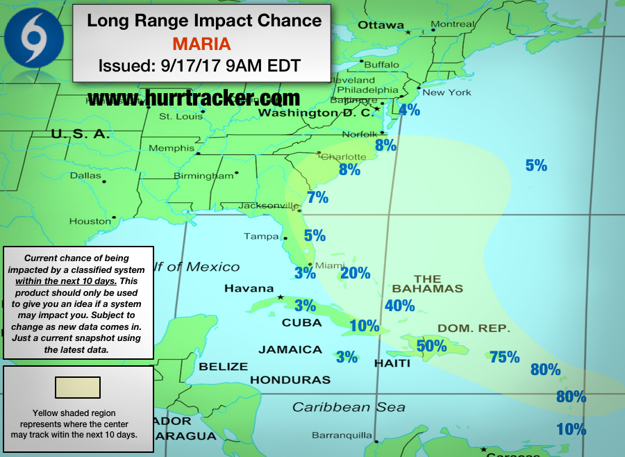
Hurricane Maria: This storm will be the highest impactful storm out of the three currently in the Atlantic because it will be the strongest and it will impact the Caribbean Islands that were already devastated by Hurricane Irma. There are numerous watches and warnings in effect, please see the full list below. Maria is forecasted to strengthen into a major hurricane in 3 days before reaching the U.S./British Virgin Islands and Puerto Rico. Later on in this week, it will continue its west-northwest track as a major hurricane moving through the Greater Antilles, including the Virgin Islands, Puerto Rico, Hispaniola, and Turks and Caicos. All of these islands need to prepare now for major impacts from this storm. Please read the latest NHC public advisory for all the expected impacts from Hurricane Maria.

Screen Shot 2017-09-17 at 5.35.50 PM.png
205956_5day_cone_no_line_and_wind.png
Latest wind swath forecast from the NHC.

Latest wind swath forecast from the NHC.

In the long-term, the United States & The Bahamas will need to monitor Hurricane Maria. With a blocking high pressure over the Atlantic, steering these storms toward the U.S., this storm definitely poses a risk to the Eastern Seaboard. At this time, we have no idea where this storm is headed this far out in time, but the entire United States coastline will need to monitor. The European ensemble members show a very large spread by next weekend, which is when Maria may be near the Bahamas. Many of the members do take Maria into the East Coast, but as you know this forecast will very likely change. It's important to note that if Hurricane Jose slows down or stalls off the New England coast it may create a south to north steering flow and could help Maria track into the open Atlantic. See the two scenarios below:

hurrtrackerapp_2017-Sep-17 1.jpg
hurrtrackerapp_2017-Sep-17 2.jpg
Hurricane Tracker App Long Range Outlook

Hurricane Tracker App Long Range Outlook

Our latest video update on Jose & Maria:

We’ll another tropical update on all three of these storms this Monday. -- Jackson Dill, Hurricane Tracker Team

9/16/17 - Jose Will Brush The Eastern U.S. & Maria May Follow In Irma's Footsteps

It’s been awhile since we’ve had a very active hurricane season like this year’s. There are three active storms in the Atlantic: Hurricane Jose, Tropical Storm Lee, and Tropical Storm Maria. We’re going to break down each storm for you so you know where each one is headed and what impacts each storm may pose.

Hurricane Jose: Jose will continue to indirectly impact parts of the U.S. East Coast this weekend. Even though it’s hundreds of miles off the Southeast coast, rip currents and elevated surf are impacting the region. It is beginning to move to the north, propagating the waves with it. By the time we get to Wednesday, direct impacts will be felt across parts of Southern New England as Jose likely weakens into a tropical storm. Expect showers and gusty winds, which may occasionally gust to tropical-storm-force (39+ mph). As the jet stream picks up Jose once it gets to this latitude, it will quickly exit to the east and will be out of the Northeast region by Thursday. The main takeaway with this storm is that other than some gusty winds and rain for southeastern New England, the rest of the East Coast of the U.S. will deal with large waves and dangerous rip currents. If you are in SE New England, including Rhode Island, southeastern Massachusetts, as well as eastern Long Island, I would recommend you stock up on some extra water and batteries just in case you lose power.

204057_5day_cone_no_line_and_wind.png

We have issued Alert Levels for Jose. That includes an ‘Elevated’ Alert Level for southeastern New England and a ‘Guarded’ Alert Level for the New York City area because some gusty winds are still possible there.

key.png

Tropical Storm Lee: Lee, which used to be Invest 97L, is the least impactful storm in the Atlantic basin at this moment. I like to call storms like this a “fish-storm” because Lee will really only impact the ocean. If you take a look at the National Hurricane Center’s forecast cone below, notice how it remains a tropical storm in the middle of nowhere through early next week before it weakens into a post-tropical storm later in the week.

Tropical Storm Maria: Believe it or not, the storm that is the weakest poses the greatest risk to life and property. The National Hurricane Center upgraded Tropical Depression Fifteen to TS Maria this afternoon.

A Hurricane Watch is in effect for Antigua, Barbuda, St. Kitts, Nevis, and Montserrat. A Tropical Storm Watch is in effect for St. Lucia, Martinique, Guadeloupe, Dominica, Barbados, St. Vincent and the Grenadines.. More watches will likely be issued by the end of this weekend as Tropical Depression Fifteen gets closer.

Maria is likely to strengthen into a hurricane by Tuesday as it begins to impact many of the Leeward Islands, including Barbuda, which was heavily damaged by Hurricane Irma earlier this month. Maria's forecasted track is very similar to Irma's. There's even the potential Maria rapidly strengthens into a major hurricane before it affects these Caribbean Islands, just like Irma did. Later on in the week, it will continue its west-northwest track as a hurricane through the Greater Antilles, including the Virgin Islands, Puerto Rico, Hispaniola, and Turks and Caicos. All of these islands need to prepare now for impacts from this storm.

204552_5day_cone_no_line_and_wind-2.png

In the long-term, the United States and the Bahamas will need to monitor what will likely be Hurricane Maria. With a blocking high pressure over the Atlantic, Maria may be steered westward without an easy path out to sea. At this time, we have no idea exactly where this storm is headed this far out in time but the entire United States coastline will need to monitor. The European ensemble members show a very large spread by next weekend, which is when Maria may near the Bahamas. Many of the members do take Maria into the East Coast, but as you know this forecast will very likely change. For now, we have a less than 5% chance of Maria impacting the eastern U.S. seaboard within the next 10 days. We will update this graphic in app as new data comes in each day.


We have issued 5 day Alert Levels for Tropical Storm Maria. That includes an ‘Elevated’ Alert for portions of the Lesser Antilles, Puerto Rico and the U.S./British Virgin Islands.

We’ll another discussion on all three of these storms this Sunday.


-- Jackson Dill, Hurricane Tracker Team