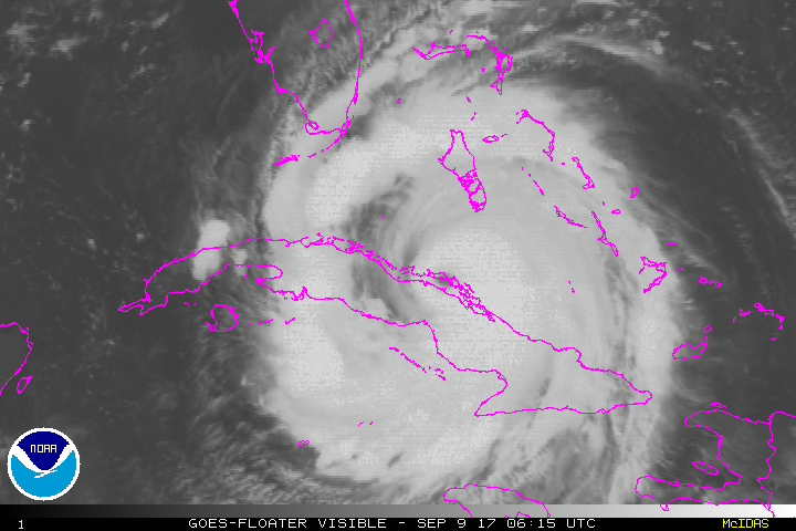
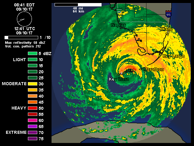
9/10/17 - Irma Has Made Landfall In The FL Keys, But Effects Are Far From Over

Overview: Today marks the climatological peak of the Atlantic hurricane season and also the first time 2 Category 4+ storms have made landfall in the United States in the same season. The center of Hurricane Irma made landfall at Cudjoe Key in the lower Florida Keys at 9:10 am EDT. However, the effects from Irma are far from over as this will be a multi-day event of significant impacts to the Southeast U.S. 

WUNIDS_map-3.gif

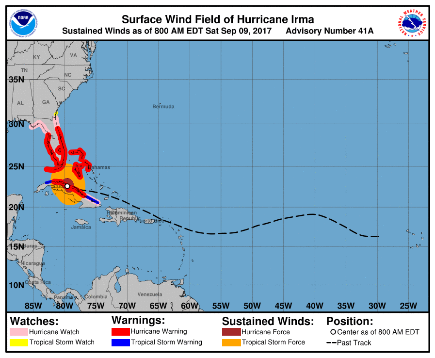
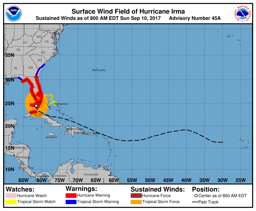
Watches/Warnings: A Storm Surge Warning is in effect for South Santee River southward to Jupiter Inlet, North Miami Beach southward around the Florida peninsula to the Ochlockonee River, Florida Keys, and Tampa Bay. A Hurricane Warning is in effect for Fernandina Beach southward around the Florida peninsula to Indian Pass, Florida Keys, Lake Okeechobee, Florida Bay, Cuban provinces of Ciego de Avila, Sancti Spiritus, Villa Clara, Matanzas, and La Habana. A Hurricane Watch is in effect for north of Fernandina Beach to Edisto Beach. A Tropical Storm Warning is in effect for west of Indian Pass to the Okaloosa/Walton County Line and north of Fernandina Beach to South Santee River. A Tropical Storm Watch is in effect for Bimini and Grand Bahama.

093910_current_wind_sm.png

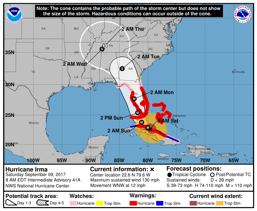
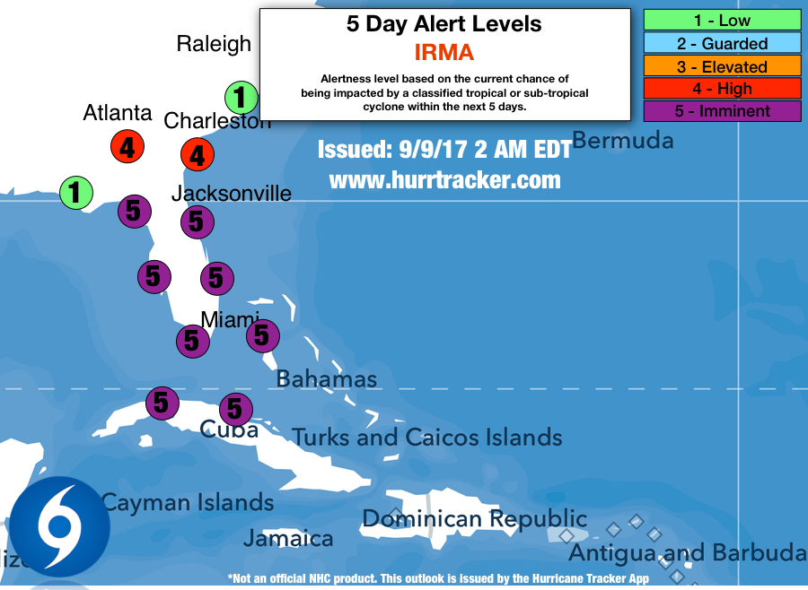
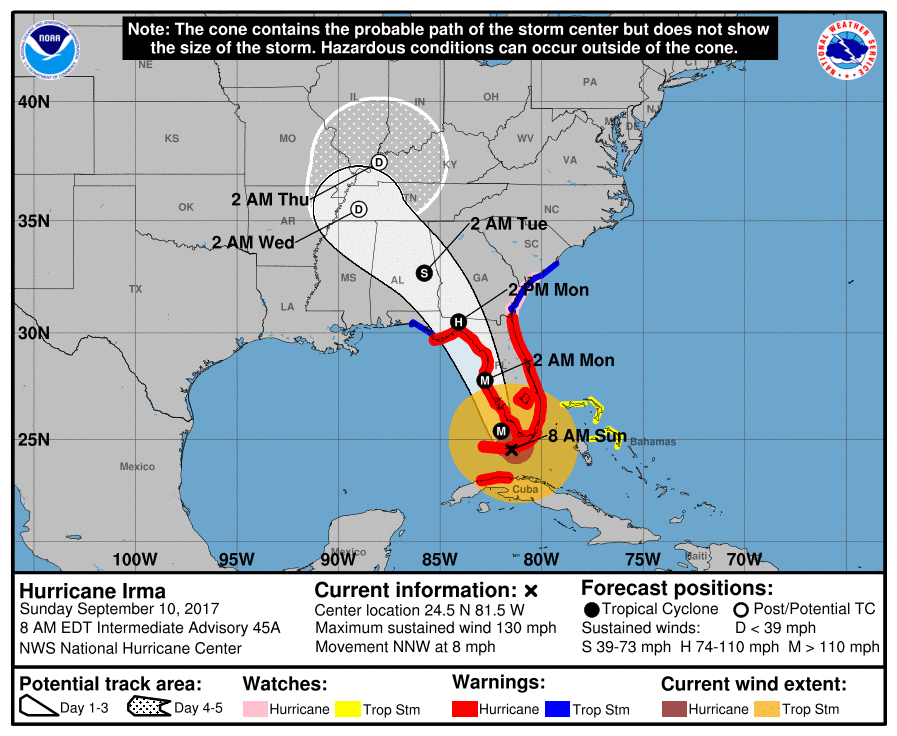
Forecast: As Irma tracks up the west FL coast, it will make a second landfall in southwest Florida in the Naples area. This is the worst-case scenario for this part of the state. Southwest Florida is so prone to storm surge and they are expected to get 10 to 15 feet. The storm surge forecast maps show entire cities going underwater, like Naples, Marco Island, Fort Myers, and Cape Coral. Irma will continue to follow a northward path, basically riding the west coast of Florida. Because of how close she will still be to the water, this may allow her to maintain much of her strength as a hurricane through her life over the Florida Peninsula. We are also concerned about storm surge in Tampa Bay, where 3 to 5 feet of inundation is forecast. The large majority of the west coast of the Peninsula can expect sustained winds of at least 100 mph and gusts as high as 130 mph. Even though we’re focusing on the western half of the Florida Peninsula, this storm will very much be an eastern half event as well. The good news is that the center of Irma won’t track over the Miami area, therefore winds will be “lighter” with winds sustained up to 70 mph and gusts up to 100 mph. Much of the same is forecast for the remainder of the east coast of Florida with slightly weaker winds in the cards. 3 to 5 feet of inundation is forecast along the coast in the Miami Beach area. Further north, expect up to 4 feet of surge. The Florida Panhandle is also going to deal with impacts from Irma. Up to 3 feet of storm surge is forecast for the Big Bend of Florida with eastern portions of the Panhandle experiencing peak wind gusts of up to 90 mph. Localized flooding due to rainfall is also possible. South Florida will get the heaviest of the rain. Some locations will receive over one foot of total rainfall. With that heavy rain falling over Lake Okeechobee, there are concerns for flooding along the lake due to water levels rising. In Georgia, strong winds and heavy rains are the main risks. Winds may gust up to hurricane-force as far north as Atlanta. Rainfall totals may top 8 inches in southern Georgia. Along the coast, which is where all residents are ordered to evacuate, significant storm surge is possible. South Carolina will also deal with gusty winds up to 50 mph and storm surge expected as far north as Charleston in the range of 3 to 6 feet. As Irma moves further north, it will considerably weaken into a remnant low early next week as most of the rain dissipates and the winds calm down.

To view exactly how storm surge may impact your location, check out the National Hurricane Center’s storm surge inundation maps here:

http://www.nhc.noaa.gov/refresh/graphics_at1+shtml/035210.shtml?inundation#contents

Conclusion: Hurricane Irma will be a historic storm, impacting Florida in a way we have never seen before. Irma is massive with hurricane-force-wind spanning over 70 miles away from its center and tropical storm force winds 200 miles from the center. Much of the FL peninsula will experience hurricane force winds. We will have another update on Hurricane Irma as conditions warrant. Thanks for using our service.

-Jackson Dill, Hurricane Tracker App Team


9/9/17 - Irma Is Ready To Make Her Mark In History

Overview: The final day has arrived for Florida to finish all preparations and evacuations. Irma will bring tropical storm conditions later today followed by intense hurricane conditions tomorrow morning. Irma will make landfall along the west coast of FL Sunday afternoon as a major hurricane with winds near 150 mph.

Watches/Warnings: A Storm Surge Warning is in effect for Volusia/Brevard County Line southward around the Florida peninsula to Chassahowitzka, Florida Keys, and Tampa Bay. A Storm Surge Watch is in effect for North of the Volusia/Brevard County Line to the Flagler/Volusia County line and north of Chassahowitzka to Suwannee River. A Hurricane Warning is in effect for Flagler/Volusia County Line southward around the Florida peninsula to Chassahowitzka, Florida Keys, Lake Okeechobee, Florida Bay, Cuban provinces of Camaguey, Ciego de Avila, Sancti Spiritus, Villa Clara, and Matanzas, Central Bahamas, Ragged Island, and Northwestern Bahamas. A Hurricane Watch is in effect for north of the Flagler/Volusia County Line to Fernandina Beach north and west of Chassahowitzka to Indian Pass and Cuban provinces of Holguin and Las Tunas. A Tropical Storm Warning is in effect for Cuban provinces of Holguin, Las Tunas, La Habana, and Ciudad de la Habana. A Tropical Storm Watch is in effect for north of Fernandina Beach to Altamaha Sound.

095407_current_wind_sm.png

Forecast: Hurricane Irma continues to ride right along the northern coast of Cuba, which has weakened it only a little to a 155 mph category 4 hurricane. It is expected to take that long expected northerly turn some time today. Throughout the day in South Florida, some of the outer bands hundreds of miles away from Irma’s center will pivot into the region, causing periods of gusty showers. Sunday morning, Irma will make her first landfall on the Florida Keys, especially the western Keys like Key West, as a strong category 4 or possibly 5 hurricane. That means sustained winds in the Keys may be up to 150-160 mph, and storm surge will be 5 to 10 feet. If you have not evacuated these islands, you need to do so by Saturday afternoon. Almost all of the land will be underwater. As it moves further north, it will make a second landfall on southwest Florida in the Naples area. This is the worst-case scenario for this part of the state. Southwest Florida is so prone to storm surge and they are expected to get 8 to 12 feet of it. Irma will continue to follow a northward path, basically riding the west coast of Florida. Because of how close she will still be to the water, this may allow her to maintain much of her strength as a hurricane through her life over the Florida Peninsula. Along with winds, we are also concerned about storm surge in Tampa Bay, where at least 3 to 5 feet of inundation is forecast. The large majority of the west coast of the Peninsula can expect sustained winds above hurricane force and gusts over well over 100 mph close to the center. Even though we’re focusing on the western half of the Florida Peninsula, this storm will very much be an eastern half event as well. The good news is that the center of Irma won’t track over the Miami area, therefore winds will be “lighter” with winds sustained up to 70 mph and gusts up to 90 - 100 mph. Much of the same is forecast for the remainder of the east coast of Florida with slightly weaker winds the further north you are. 5 to 10 feet of inundation is forecast along the coast in the Miami Beach area. Further north, expect up to 5 feet of surge. Eastern portions of the Florida Panhandle is also going to deal with impacts from Irma. There is a Hurricane Watch in place. Up to 3 feet of storm surge is forecast for the Big Bend of Florida with eastern portions of the Panhandle experiencing peak wind gusts of up to 70 mph. Localized flooding due to rainfall is also possible. South Florida will get the heaviest of the rain. Some locations will receive over one foot of total rainfall. With that heavy rain falling over Lake Okeechobee, there are concerns for flooding along the lake due to water levels rising. In Georgia, strong winds and heavy rains are the main risks. Winds may gust up to hurricane-force as far north as Atlanta. Rainfall totals may top 8 inches in southern Georgia. Along the coast, which is where all residents are ordered to evacuate, significant storm surge is possible. South Carolina will also deal with gusty winds up to 50 mph and storm surge expected as far north as Charleston. As Irma moves further north, it will considerably weaken into a remnant low early next week as most of the rain dissipates and the winds calm down.

To view exactly how storm surge may impact your location, check out the National Hurricane Center’s storm surge inundation maps here: http://www.nhc.noaa.gov/refresh/graphics_at1+shtml/035210.shtml?inundation#contents

Alert Levels: We have issued “Imminent” Alert Levels for all of the Florida Peninsula. We have also issued “High” Alert Levels for Georgia and southern South Carolina. Please review our key below for recommended actions to take based on the alert level issued for your area.

93lalertlevel.png
key.png

Conclusion: Hurricane Irma will be a historic storm, impacting Florida in a way we have never seen before. Irma is massive with hurricane-force-wind spanning over 70 miles away from its center, therefore bringing hurricane conditions to most of the state. Millions will lose power, so please make sure you are prepared as this very dangerous storm gets ready to pound parts of the United States. Unfortunatley, Irma is ready to take her placed in history. 

We will have another update on Hurricane Irma as conditions warrant. Thanks for using our service.

-Jackson Dill, Hurricane Tracker App Team