9/8/17 - Dangerous Hurricane Irma To Cause Widespread Damage In FL Sun/Mon
Overview: Hurricane Irma continues to inch its way closer to the United States. Today, it will impact the Central Bahamas as a strong category 4 storm. It is headed for warmer water, so there is the potential it re-strengthens again before landfall in south Florida on Sunday.
Watches/Warnings: A Storm Surge Warning is in effect for Jupiter Inlet southward around the Florida peninsula to Bonita Beach and the Florida Keys. A Storm Surge Watch is in effect for North of Jupiter Inlet to Sebastian Inlet and North of Bonita Beach to Venice, FL. A Hurricane Warning is in effect for Jupiter Inlet southward around the Florida peninsula to Bonita Beach, Florida Keys, Lake Okeechobee, Florida Bay, Haiti from the northern border with the Dominican Republic to Le Mole St. Nicholas, Southeastern Bahamas and the Turks and Caicos Islands, Cuban provinces of Camaguey, Ciego de Avila, Sancti Spiritus, and Villa Clara, Central Bahamas, and Northwestern Bahamas. A Hurricane Watch is in effect for North of Jupiter Inlet to Sebastian Inlet, North of Bonita Beach to Anna Maria Island, and Cuban provinces of Guantanamo, Holguin, Las Tunas and Matanzas. A Tropical Storm Warning is in effect for Haiti from south of Le Mole St. Nicholas to Port-Au-Prince and Cuban provinces of Guantanamo, Holguin, and Las Tunas.
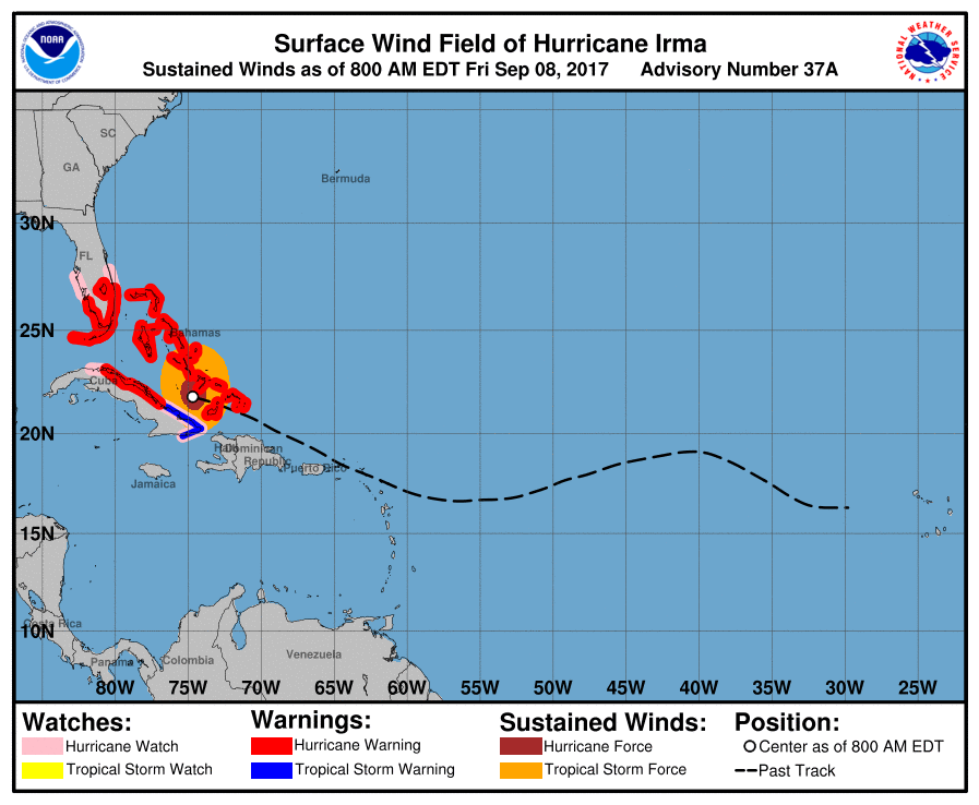
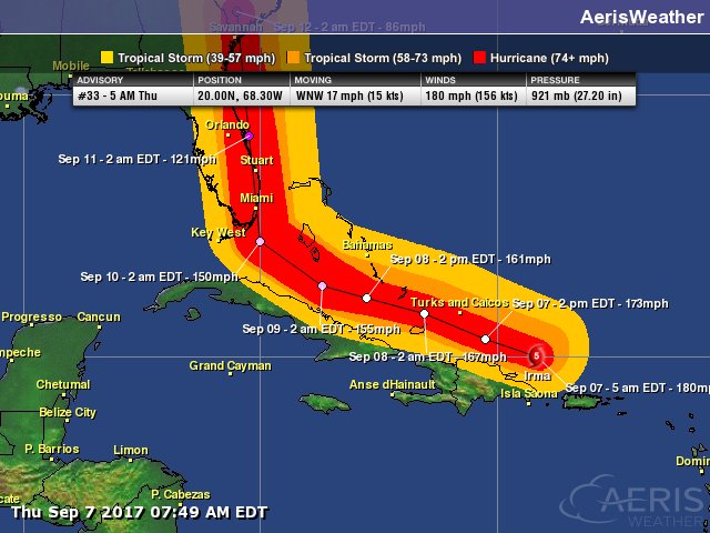
Intensity: Irma has "weakened" to a strong category 4 storm with winds at 150 mph. Irma is forecasted to remain a category 4 up until landfall in South Florida. At this moment, the National Hurricane Center forecast states that Irma will have 150 mph at the time of landfall, but with very warm oceans we wouldn’t be surprised if it ends up being a bit stronger that the current forecast.
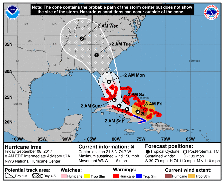
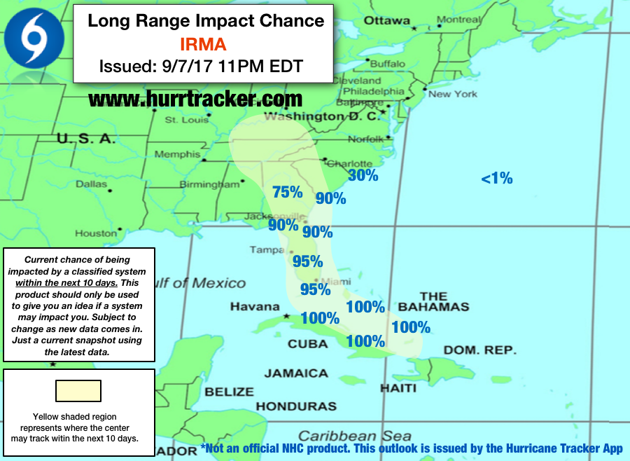
Track (Short-Term): The certainty remains high the next few days in regards to where Hurricane Irma is headed. Today, it will then impact the central Bahamian islands where hurricane-force winds, catastrophic storm surge and heavy rain are expected. Cuba will also likely hurricane conditions late tonight into Saturday. Then, the effects of Irma will begin to be felt in South Florida on Saturday with tropical-storm-force winds and showers moving in. There will be a landfall in this region early Sunday morning. The question of when the northward turn happens is still there, but itdoesn’t matter as much with this storm because of how widespread the impacts with Irma will be because of the size of this massive storm. It is forecast to move up the entire Florida Peninsula through Monday, bringing hurricane-force-winds to much of the entire peninsula which will certainly cause widespread damage and a widespread loss of power to millions. We can’t stress enough how this is going to be an inland storm as well, not one only affecting the coast. All of the Florida Peninsula will get heavy rain and strong winds that can cause widespread power outages and structural damage. The FL Panhandle will receive little to no effects from Irma. The impacts will still be the worst along the coast due to a storm surge of 5 to 10 feet from Jupiter Inlet to Bonita Beach, including the Florida Keys. Bonita Beach to Venice and Jupiter Inlet to Sebastian Inlet can expect a 3 to 6 foot surge. All preparations in South Florida need to be rushed to completion today.
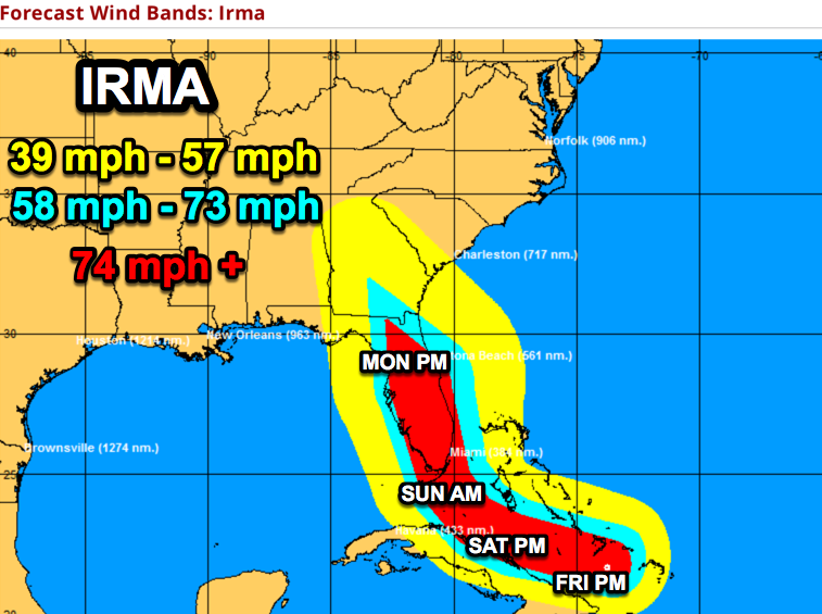
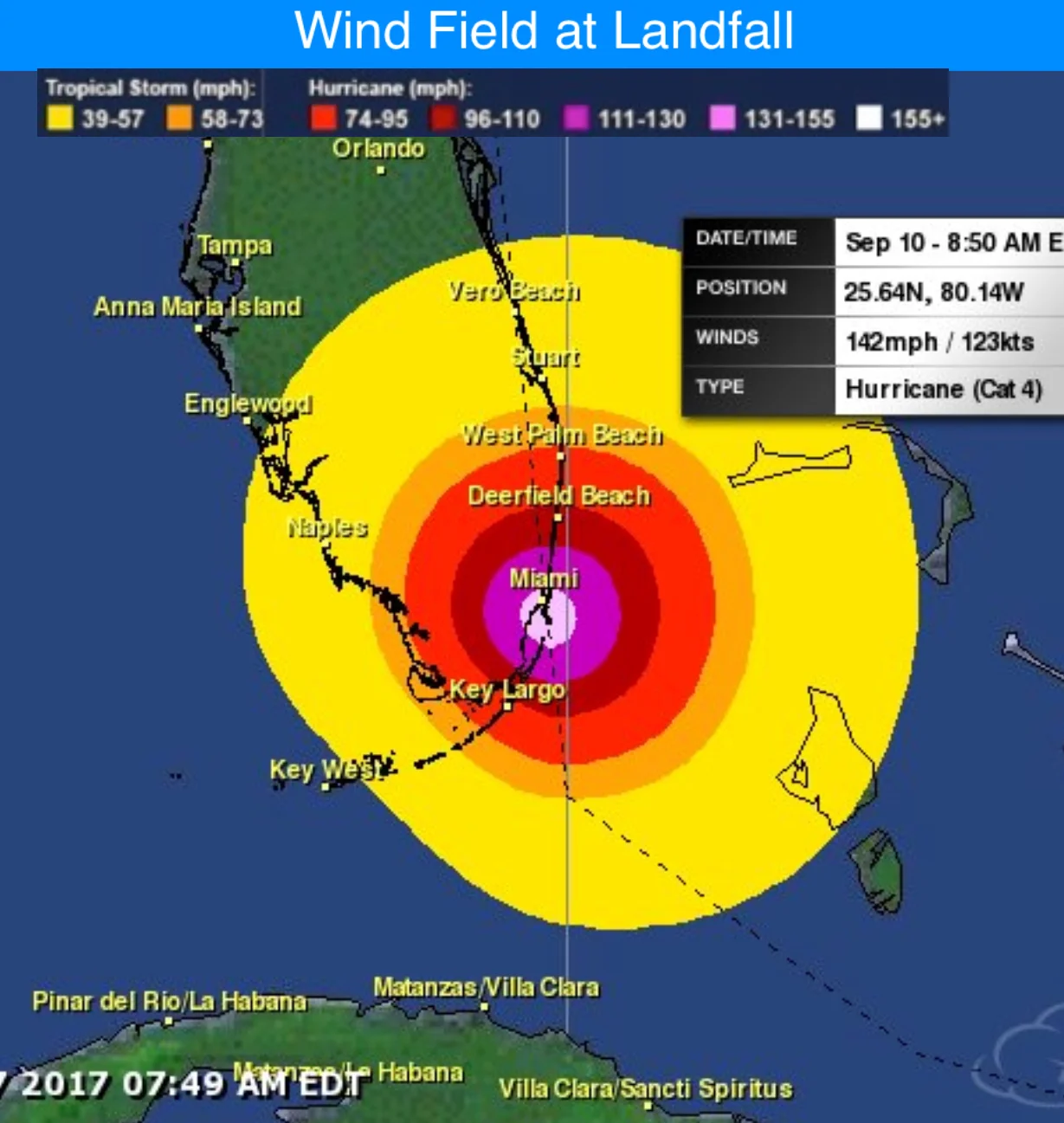
Irma is forecast to bring hurricane force winds to much of the FL peninsula out shown by the red shaded area.
Track (Long-Term):There is still some uncertainty early next week, but we think Irma will head into Georgia, still as a category 4 hurricane. Power outages are also likely in this state due to the strong winds and widespread trees. There will be an onshore flow along the Georgia and South Carolina coasts, so a storm surge is possible. It’s still early to say how much the water levels will rise at this time. Heavy rain is also a threat with some locations, especially in southeast Georgia, expected to pick up to a foot of rainfall. Mid-next week, the storm will considerably weaken and get sheared as it loses all the dynamics to hold together as it moves further inland.
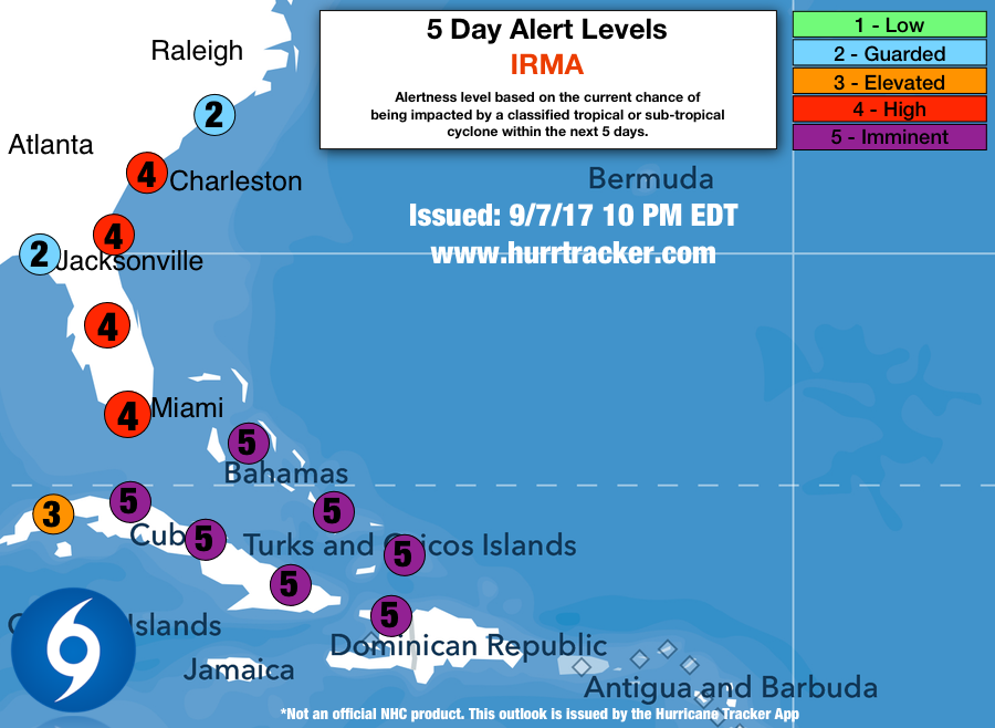
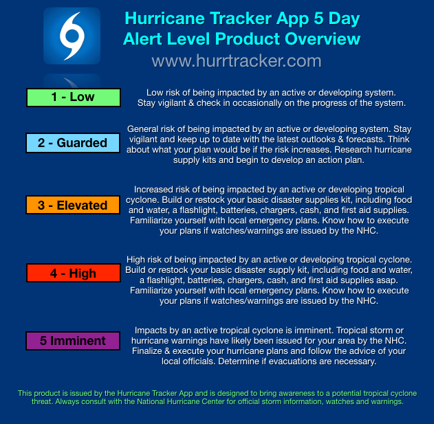
Alert Levels: We have issued “High” Alert Levels for South, Central, and northeastern Florida. We have also issued Alert Levels for Georgia and the Carolinas. Please review our key below for recommended actions to take based on the alert level issued for your area.
Conclusion: Hurricane Irma is a catastrophic hurricane that you have to prepare for if you are in it’s path. Millions of people will be affected by this destructive storm. This will likely be one of the largest loss of power ever experienced as millions of residents will lose power for several days, if no longer. Unfortunately, it's likely to cause more damage in terms of dollars than Hurricane Andrew, Charley and Wilma.
We will have another update on Hurricane Irma as conditions warrant. Thanks for using our service.
-Jackson Dill, Hurricane Tracker App Team