Latest Discussion On Hurricane Matthew. Final Track Is Still Uncertain
Matthew is a major hurricane. Check the storm page under "Current Storms" for all the latest information, maps & advisories. Information there is updated in real time. This section is not meant to provide real time information. This is where we post our analysis each evening. We will have a new detailed discussion on Matthew later on Monday evening. Please see our most recent discussion issued Sunday night below:
If you would like to receive these updates the moment they are published, please click here to sign up for email updates.


Overview: Matthew is a major hurricane and will be impacting Jamaica, Haiti, the Dominican Republic, eastern Cuba and the Bahamas over the next few days. Hurricane force winds extend out up to 35 miles from the center and tropical storm force winds extend out 205 miles from the center.

Watches warnings: See the image below for the latest watches & warnings from the NHC:

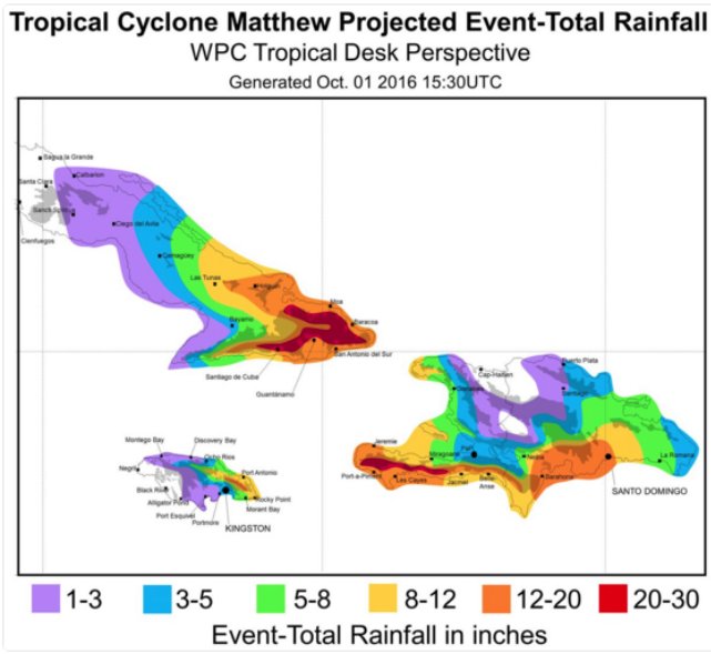
Impacts: The areas currently under hurricane watches and warnings may not only experience hurricane force winds, but rainfall accumulations of 15 to 25 inches with isolated amounts of 40 inches across eastern Cuba and western Haiti. 5 to 10 inches of rain is expected across eastern Jamaica. These rainfall amounts will likely produce life-threatening flash floods and mudslides. 8 to 12 inches of rain is expected over the southeastern Bahamas. Storm surge could be as high as 7 to 11 feet and eastern Cuba and the south coast of Haiti. A 3 to 5 foot storm surge it is expected in Jamaica. Everyone in these regions should complete preparations by tomorrow morning in anticipation of Hurricane Matthew. Unfortunately, impacts may be devastating in some areas.
Intensity Forecast: Matthew is expected to remain at least a category 3+ hurricane through the next 48 hours and then begin to weaken a little bit on days four and five. Even though Matthew may weaken to a category 2 hurricane winds should remain over 100 mph through the next five days or so. The National Hurricane Center does caution their confidence in the intensity forecast is low.
Track Forecast: Matthew is expected to track towards the north through Wednesday then turn towards the northwest generally towards the southeastern United States coast. Confidence is fairly high with the overall track through the next three or four days.

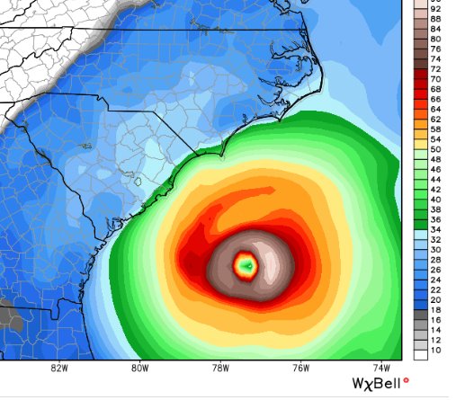
Latest Model Guidance: Beyond five days, computer models still do not have a handle on what Matthew’s final track will be. Some runs are bringing Matthew dangerously close to the coast of the Carolinas (see image below), while many others keep Matthew safely offshore. A forecasted upper-level trough over the central United States and an upper level ridge of high-pressure over the western Atlantic will be the main steering features that determine the final track. If the high-pressure ridge is stronger than forecasted, it could push Matthew very close to the United States coast, but if the trough of low pressure is deep enough or moves east quickly it could turn Matthew out to sea and spare the United States seaboard. Hopefully in the next couple days we will have more clarity from the models in the guidance on Matthews final track.

Alert Levels: We have issued high to imminent alert levels along Matthews track for the next 2 to 3 days and we have also issued guarded to elevated alert levels for portions of the southeast United States coast as we do think there's a good chance Matthew could get within a couple hundred miles of the coast and maybe even bring tropical storm conditions to portions of the Carolina coast lines. Matthew will be close enough so that coastal flooding, beach erosion and rip currents will be a big problem along the coast. See our alert level key below.


Conclusion: All interests from Florida through the entire eastern seaboard, including the Canadian Maritimes, needs to continue following the future forecast for Matthew. There's still much uncertainty in the long range as to whether or not the United States or Canada will see direct impacts. We will be here with more updates as new data comes in. Thank you for using our service and we will have another update tomorrow evening.
Follow our Twitter feed @hurrtrackerapp for more detailed and frequent updates on the models and real time data