Matthew Is A Dangerous Hurricane & Will Have Impacts Early Next Week
Matthew is a major hurricane. Check the storm page under "Current Storms" for all the latest information, maps & advisories. Information there is updated in real time. This section is not meant to provide real time information. This is where we post our analysis each evening. We will have a new detailed discussion on Matthew later on Saturday evening. Please see our most recent discussion issued Friday night below:
What a remarkable 48 hours we have witnessed in the Caribbean Sea. Matthew went from a tropical storm to a Category 5 hurricane in about 36 hours. Despite low to moderate wind shear, Matthew has rapidly intensified to the strongest storm we've seen in a few years. Only 24 hurricanes in the Atlantic basin since 1851 have rapidly intensified at least 60 knots in 24 hours.
If you would like to receive these updates the moment they are published, please click here to sign up for email updates.


A hurricane warning has been issued for Jamaica and most of Haiti. A hurricane watch is in effect for eastern Cuba. We are very concerned about severe impacts in Jamaica/Haiti on Monday and eastern Cuba on Tuesday. All indications are that Matthew will remain a dangerous major hurricane over the next few days. We will likely see fluctuations with intensity, but overall Matthew should remain a category 3+ hurricane. Jamaica, eastern Cuba and the central Bahamas should begin preparations as soon as possible for Matthew’s arrival. Confidence is fairly high that Matthew will turn towards the north before the weekend is over and head towards the eastern side of Jamaica. After Jamaica, Matthew will move over eastern Cuba and into the Bahamas by midweek. Please do not take the storm lightly if you are in its path. Sustained winds may be well over 100 mph close to the center and flooding rains are likely in portions of these regions.

Hurricane Tracker App 5 Day Alert Levels

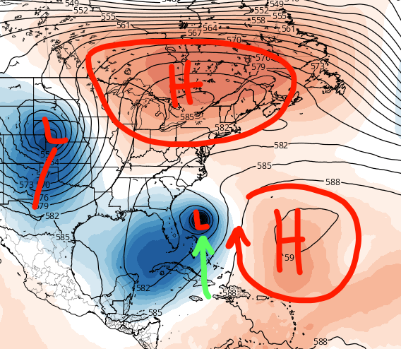
A lot of people have been asking us and the National Hurricane Center, where is Matthew going to track beyond the next 4-5 days? The honest answer to that is, we simply do not know at this time. We have a general idea that Matthew could be located within a few hundred miles of the east Coast late next week. Because of that, it's very important for all residents an interests from south Florida all the way to southeast Canada should monitor the progress of the hurricane very closely over the next several days. We can say, that the threat to the Gulf of Mexico is very, very low at this time. The upper level steering pattern just does not support Matthew making it into the Gulf of Mexico. There would have to be some awfully dramatic changes with the forecast for that to occur.
Every six hours the computer models run and we get fresh data. We are not necessarily looking at the exact track of each model, but more so what the trends are from run to run and model to model. We can say over the last couple days the models have been trending west, closer to the coast pretty much with every run. The models have been underestimating the ridge of high-pressure parked over the southwest Atlantic which is the primary steering mechanism for pushing the storm off to the west. If this ridge of high-pressure is weaker than what the models forecast, then Matthew would easily go out into the open Atlantic after impacting the Bahamas. But if the ridge of high-pressure is stronger, it could potentially push Matthew closer and closer to the United States coastline. We are talking about a 6 to 10 day forecast, and it's almost impossible to know the exact strength and placement of this ride and other upper level features that will contribute to the final path of Matthew. Our technology is just not that good yet. By the end of the weekend we should have a little clearer picture as to where Matthew may end up.

Models begin to diverge after 4 days.
We will be here over the next several days to keep you updated. We usually try to issue these discussions at the end of the day once all the model data has been reviewed. We will also issue a audio and video updates as necessary. For those of you in the path of Matthew, it's time to plan and prepare and for those of you along the east coast of United States, let's just keep watching what happens as we have plenty of time before any potential impact.
Follow our Twitter feed @hurrtrackerapp for more detailed and frequent updates on the models and real time data.