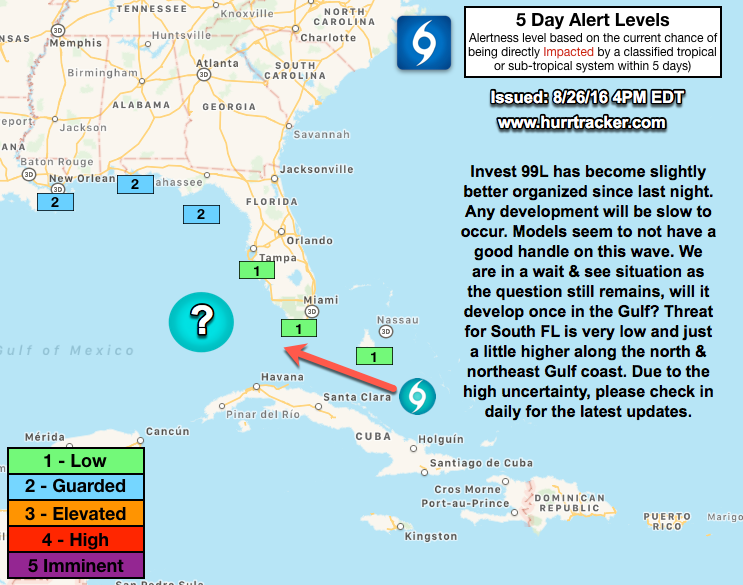
8/27/16 - Invest 99L Getting Better Organized. Slowly...

8/27/16 - We will have a new post and email update later this evening on #99L. Some interesting developments today. No imminent threat to land or south Florida though.

What a roller coaster ride it has been with Invest 99L. This has been the most challenging system to forecast as the models are performing very poorly. There is some evidence that 99L has become better organized today and is producing sustained periods of convection near its broad center. Wind shear is low above the system, but it has come down significantly since yesterday and 99L will continue to move into a more favorable environment and warmer ocean temperatures. The NHC states there is a 60% chance of development.

While it appears the threat for a tropical cyclone across S FL is low (cannot completely be ruled out), the threat for heavy rains this weekend and early next week exists. Localized flooding may become a concern across parts of S FL as this system passes through the Florida Straits. 

If you are a resident or have an interest along the north or northeastern Gulf Coast, continue to check in daily on this system as there is a medium chance it could develop in the Gulf and affect someone. There is high uncertainty with this outlook and we will let you know when the forecast becomes more clear, for now just remain vigilant. 

~Hurricane Tracker App Team

If you would like to receive these updates the moment they are published, please click here to sign up for email updates.

8/25/16 - Big Developments With 99L Today. FL Threat Is Diminishing

There is some really good news to report this afternoon. Throughout the day today, Invest 99L has become further disorganized as upper level wind shear has really put a cap on thunderstorm development. The weak area of low pressure is moving towards the west-northwest and is weakening because of the lack of convection. It also appears the weak area of low pressure might run into Cuba and fizzle out. The chance of this system developing before it reaches the Bahamas or South Florida, have lowered dramatically this afternoon. We have lowered our alert level down to the low category for the Bahamas and South Florida (see image below). For those of you in the northern Gulf of Mexico we kept guarded alert levels due to the possibility it organizes once in the gulf.

It is still too early to completely write off the system as there is a chance it could try to organize again in the Southeast Gulf of Mexico. Upper-level winds and sea surface temperatures in the Gulf of Mexico appear to be favorable to support organization if the system survives over the next 2-3 days.

While the threat is diminishing, we urge everyone from the Bahamas through the entire gulf Coast to continue to keep an eye on the system in case it does try and re-organize. We suspect that the National Hurricane Center will continue to lower their development chances over the next few outlooks based on the recent trends in the computer models and the real-time satellite data.

Please listen to our audio update which can be found on the overview page for more in-depth information on the big developments today with this system. Thank you for using the Hurricane Tracker app and we will notify you asap of any big changes going forward. Have a great evening.

~Hurricane Tracker App Team