
8/1/16 - Invest 97L Is Close To Tropical Storm Status
Satellite imagery reveals that Invest 97L has continued to become better organized during the past 24 hours. The NHC states there is a 90% chance of development over the next 5 days. The Hurricane Hunters were en-route this afternoon and had to turn around due to maintenance issues. The NHC has been unable to confirm if there is an organized surface low pressure area. All the twisting seen on satellite, appears to be in the mid-levels. Regardless of short term classification, the strong wave will bring heavy rain and 40-50 mph winds to Jamaica overnight. Despite the lack of classification, the impacts for Jamaica will remain the same.
Receive our detailed discussions via email as soon as they are published, please tap here. Our posts are updated as conditions warrant, but all storm data including advisories, maps, models and NHC data within the storm pages are updated in real time.
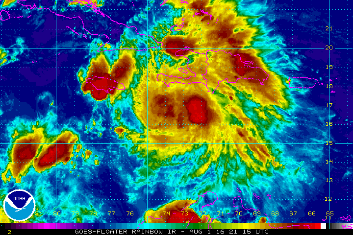
97L may look like a tropical storm, but the NHC is waiting to confirm a closed surface low.
Track: Confidence is high that Invest 97L will move towards the west over the next few days generally towards Belize and the southern Yucatan Peninsula. 97L is being steered to the west by a deep layer ridge of high pressure located over the southern United States. This high pressure has also been responsible for the recent southern heat. We are in Atlanta, and it sure has been a hot summer thanks to the persistent heat ridge. 97L is forecasted by the models to make landfall near Belize sometime on Wednesday, possibly as a hurricane. We want to note, this storm is no threat to the United States coastline.

Our team has issued high Alert Levels for portions of the Western Caribbean.
Intensity: 97L is working with a favorable environment and water temps in the mid-upper 80's that extend well below the surface - plenty of fuel for the system to feed from. Most models forecast modest strengthening over the next couple of days. At this time, we give this system a 30% chance of becoming a hurricane - it's not out of the question. All interests in the Western Caribbean should follow the progress of 97L closely.


Model guidance has been very consistent with a w-wnw track. Earl could reach the extreme southern Gulf of Mexico in 4-5 days.
August outlook: As we move deeper into August and beyond, we expect activity to continue to increase as conditions basin wide continue to improve above some very warm waters. The Atlantic has many positive factors going for it this season as compared to the last few. While we can never detect a specific threat more than a few days out, we do see some signs in the models/patterns that we could see at least one U.S. landfall threat in the weeks to come. Stay aware, alert & tuned to the Hurricane Tracker App for updates.
Please stay tuned here at the Hurricane Tracker App for frequent updates on 97L/Earl throughout the rest of this week.
We highly recommend following our Twitter (hurrtrackerapp) for real time coverage as the system tracks towards Central America.
A new post will be issue sometime on Tuesday afternoon, usually before 6PM EDT, or earlier if conditions warrant.
If you value our service, please leave a quick review for us in the App Store. Click on a link below & you will be taken to our app in the store. Thanks so much!
Open App Store: iPhone Version
Open App Store: iPad Version
Thanks! ~ Hurricane Tracker App Team
Copyright 2016 | Hurricane Tracker App | EZ Apps, Inc.


