Tue 10/8/24 - Extremely Dangerous Hurricane Milton Headed To FL
Summary: Hurricane Milton is an extremely dangerous category 5 hurricane as of this writing. Winds are sustained at 165 mph with higher gusts. Some further intensification is expected tonight. However, as the system approaches Florida on Wednesday, atmosphere conditions may not be as favorable for the storm to maintain category five intensity and it will weaken some. Regardless, Milton will bring catastrophic impacts to portions of the Sunshine State and record storm surge along the west central coast of FloridA. NO doubt it will still be a major hurricane upon landfall.
Watches & Warnings: A full range of watches and warnings are in effect for portions of Florida which includes hurricane warnings, tropical storm warnings & a storm surge warning. Please see the graphics above for locations where watches and warnings are in effect.
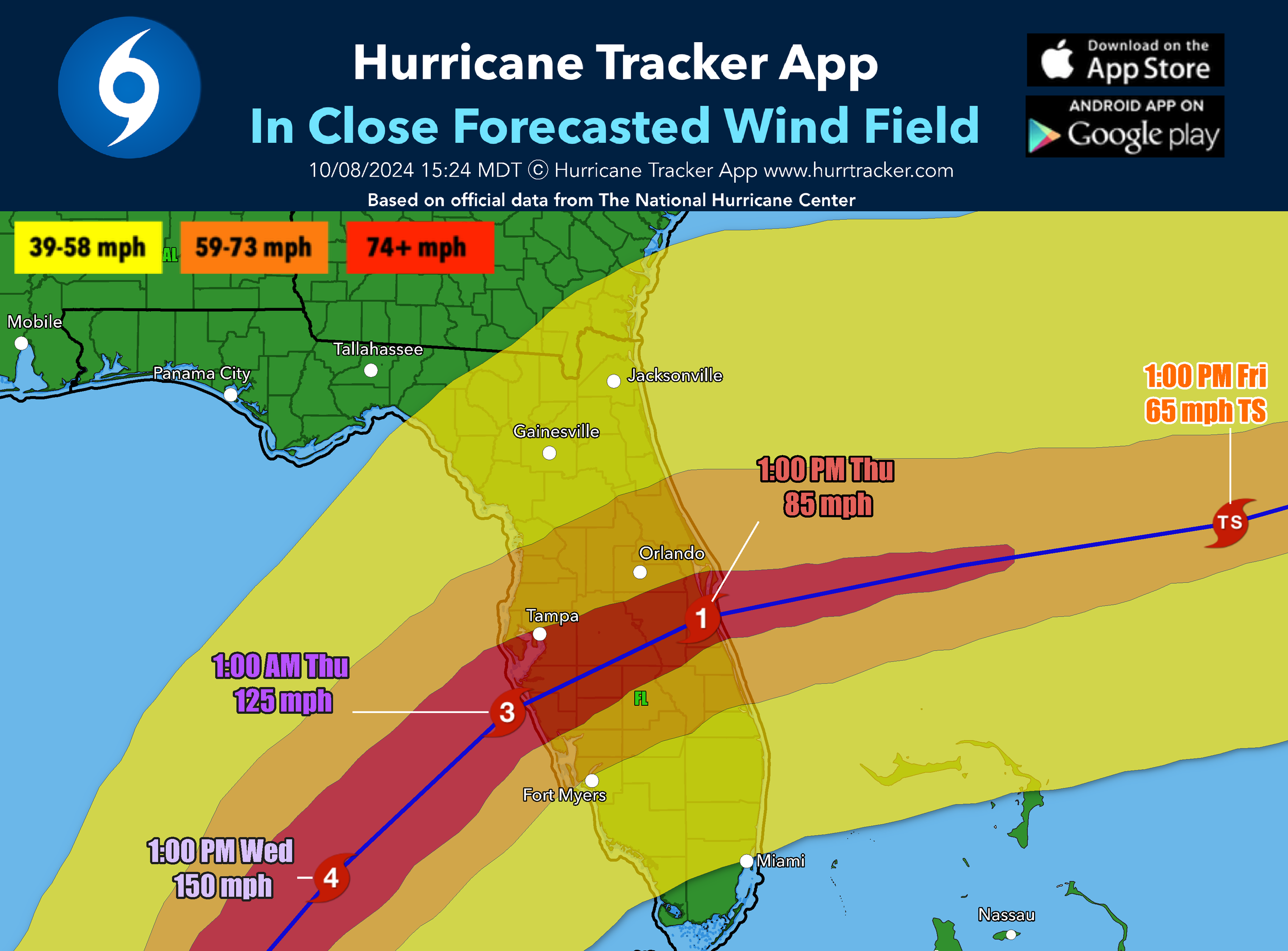
Track: Milton is tracking east-northeast across the southern Gulf of Mexico. a mid-level trough of low pressure dropping into the northwestern Gulf of Mexico. should cause Milton to turn to the east-northeast and then northeast at a faster forward speed late tonight into Wednesday. On the current forecast, the center is expected to track JUST SOUTH OF the Tampa Bay area and then track east-northeast near or just south of Orlando, then out into the Atlantic Ocean. Right now, there’s medium to high confidence in the track forecast and we only expect minor changes going forward from the NHC.
Intensity: Milton is currently one of the most powerful hurricanes we've ever seen in the Gulf of Mexico and it is forecasted to strengthen even more tonight. Wind shear is currently light and it's over very warm waters. On Wednesday, as the storm is approaching Florida, it will encounter a less favorable environment with strong shear and some dry air and entrainment. Regardless, the system is expected to be a large and powerful hurricane at landfall in Florida with life-threatening hazards at the coastline and well inland.
Rain Threat: Rainfall amounts of 6 to 12 inches with isolated totals up to 15 inches are expected across portions of the Florida peninsula through Thursday. Milton is expected to produce rainfall totals of 2 to 5 inches across the Florida Keys through Thursday.
Wind Threat: Hurricane conditions are expected in the warning areas on the West Coast of Florida as early as Wednesday afternoon with tropical storm conditions beginning early Wednesday and then spreading eastward from there wed night and thursday. Milton is expected to arrive along the West Coast of Florida as a major category 3 hurricane and slowly weaken as it crosses the peninsula (still as a hurricane). Regardless of the category, winds will be a major threat along and near where the center tracks. The latest forecast takes the center just south of Tampa bay east to just south of orlando metro before moving over the western Atlantic Ocean.
Storm Surge Threat: Unfortunately, the storm surge threat with milton will be very high. The hurricane center is expecting water rises up to 15 feet near where the center makes landfall, especially in the Tampa Bay region. This area has never seen storm surge this high, and it will be catastrophic in some areas. If you live in an evacuation zone or local officials are telling you to evacuate, please heed their warnings and do so as water inundation near the coast and near the bay will be very high. Storm surge is the number one cause for death in a hurricane. This one is serious.
Tornado Threat: A few tornadoes are possible over central and southern Florida beginning late tonight and continuing through early Thursday morning.
Recap: Unfortunately, Milton is going to be a historic hurricane with catastrophic damages over major populated areas across the central Florida Peninsula. If you are in or near the track of this system, please do everything possible to protect life and property and use Tuesday as a final day for preparations. Please listen to local authorities if they ask you to evacuate, we want everybody affected by the storm to stay safe as possible. Prolonged power outages will be very likely with this system as 100 mph winds may extend all the way to Orlando. If you are not evacuating, please have a generator if possible and prepare for days or weeks without power. Stay safe everyone and we will have a new discussion as conditions warrant.
Thank you for trusting and using the Hurricane Tracker App. We appreciate you, and please stay safe if you're along the path of the system.
Go Premium: If you are not already a premium graphics subscriber, sign up today and get higher-resolution storm graphics that contain more information such as cities & counties so you can make informed decisions. It also helps support our app since we now offer it free. We want to be around for a long time!
Premium users will also have access to wind swath graphics that the NHC does not publish. Details & sign up here > Premium Graphics Info.
Thank you for being a Hurricane Tracker App user and supporting our passion for tracking tropical cyclones!
*Above is the latest discussion from our team on Milton. For current and up to date storm information including advisories and graphics, always click on the storm name under the “Current Storms” tab below. This section is not mean’t to show the latest storm information, just the latest notification we’ve sent. Thanks.


