6/1/25 - Hurricane Season Begins Today and Ends November 30th

Welcome to the 2025 Atlantic hurricane season and our 15th year tracking storms to keep you informed without all the hype!

As you have seen from our pre-season posts, this season is expected to produce an above-average number of storms due to the warm waters in the Atlantic Basin and the lack of El Niño in the eastern Pacific.

No activity is expected in the short term. The latest 7-day NHC outlook shows nothing cooking at the moment. When we have our first tropical storm, the name will be Andrea.

The GFS model has been showing some possible development around June 7th, but it has no support from the other models at this time. We will let you know when the first Atlantic system may form.

*Note: Check out the Data Feed tab below as we have fixed some issues with the satellites and ocean temperature sections.

No storms expected through the next 7 days in the Atlantic Basin.

Here are the names that will be used this season in the Atlantic Basin.

Activity is usually quiet in June and July and picks up early August through October.

If you are not already a premium graphics subscriber, sign up today and take full advantage of what Hurricane Tracker has to offer. Details here > Premium Graphics Info. Thank you for being a Hurricane Tracker App user and supporting our passion for tracking tropical cyclones! We couldn’t do this without your support! 2025 will be our 15th year of tracking tropical systems!

Example image below of just one of our premium graphics offerings during an active storm.

Details here > Premium Graphics Info.

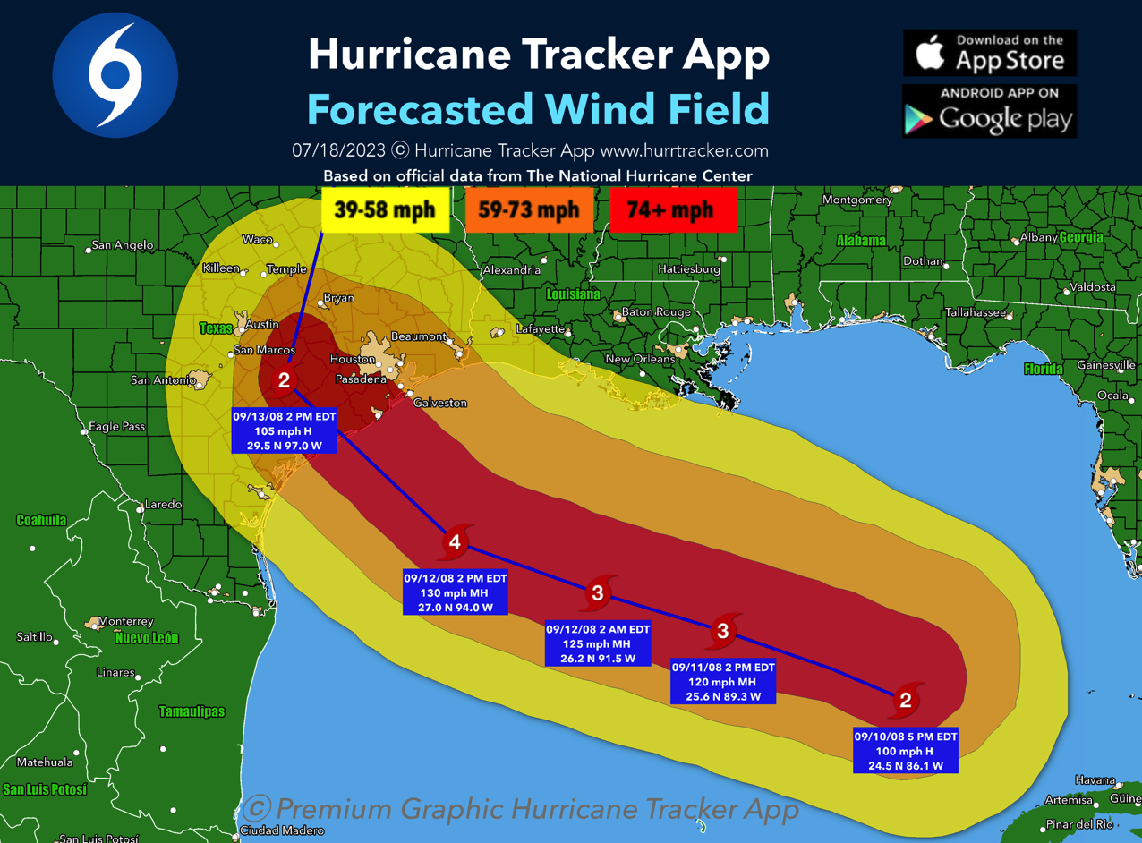
Example of the wind swath graphics available to our premium members.

5/28/25 - TD 1E - 1st System In The Western Hemisphere Forms

Tropical Depression 1E in the Eastern Pacific became the first system of the season in the Western Hemisphere earlier today. TD1E is forecasted to become Tropical Storm Alvin later tonight. Later this week, it will turn north towards Baja Mexico, but is expected to weaken dramatically due to cold waters near the coast. Little to no impact is expected for Mexico at this time. Read below for an Atlantic update.

To view Eastern Pacific storms, click on “E Pacific” at the top of the home page in the app.

For the Atlantic Basin, there’s some indication there might be a chance for development in the area of the Western Caribbean in about 10 days or so. A pulse of the MJO we be moving across the western Atlantic and that may be able to spark development. We will keep you updated on this potential. Nothing to worry about at this time.

The CPC indicates the western Caribbean may be the area to watch between June 11-17.

Ensembles showing a 40/50% chance of development in the western Caribbean within 2 weeks. Will monitor.

If you are not already a premium graphics subscriber, sign up today and take full advantage of what Hurricane Tracker has to offer. Details here > Premium Graphics Info. Thank you for being a Hurricane Tracker App user and supporting our passion for tracking tropical cyclones! We couldn’t do this without your support! 2025 will be our 15th year of tracking tropical systems!

Example image below of just one of our premium graphics offerings during an active storm.

Details here > Premium Graphics Info.

Premium graphics example for subscribers.

Alvin Is Expected In The Eastern Pacific Mid Week. No Mexico Threat

The first tropical depression of the Eastern Pacific season is expected mid-week south of Mexico. The system should stay south of the coast and weaken as water temps fall below 80°F the further WNW it tracks. Baja Mexico should be safe from this one. Will watch for any changes. The first name on the list this season for the Eastern Pacific Basin will be Alvin.

If you are not already a premium graphics subscriber, sign up today and take full advantage of what Hurricane Tracker has to offer. Details here > Premium Graphics Info. Thank you for being a Hurricane Tracker App user and supporting our passion for tracking tropical cyclones! We couldn’t do this without your support! 2025 will be our 15th year of tracking tropical systems!

Example image below of just one of our premium graphics offerings during an active storm.

Details here > Premium Graphics Info.

Premium graphics example tracking image for subscribers.