Coastal Low May Develop off the Southeast Coast This Weekend

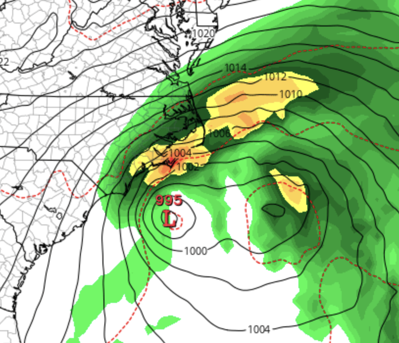
Sub-tropical depression in March? Some model data, including the Euro, indicates a slight possibility of a coastal low developing off the southeast coast this weekend. Water temps are in the mid 70’s so we would not expect a fully tropical system if development occurs. Regardless, not good beach weather next weekend for SC/NC. Nothing official from the NHC as of now. Just wanted to give our users in the southeast a heads-up. We will keep you updated on this potential development as next weekend draws closer.

The season will officially kick off on June 1st for the Atlantic and May 15th for the Eastern Pacific. If you are not already a premium graphics subscriber, sign up today and take advantage of our 20% off-season sale. Premium users will have access to these wind graphics that the NHC does not publish. It won’t last much longer! Details here > Premium Graphics Info. Thank you for being a Hurricane Tracker App user and supporting our passion for tracking tropical cyclones!

National Hurricane Center Important Forecast Changes for 2024

The start of the 2024 Atlantic hurricane season is still more than two months away, but the National Hurricane Center is busy with changes it plans to implement this year. Here are some important changes they will implement this season:

Interior watches and warnings

Last month, The Hurricane Center announced it would be changing its cone of uncertainty. The cone currently includes tropical storm and hurricane watches and warnings for coastal counties. Beginning on or around Aug. 15, the center will experiment with a cone that adds tropical storm and hurricane watches and warnings issued for interior counties across the U.S. in the path of a storm. The Hurricane Center said the experimental cone should be available within 30 minutes of the release of each advisory, giving forecasters time to add the additional information. See an example of what this will look like below.

Example: Beginning sometime in mid-August, the NHC will now show interior watches and warnings on its cone of uncertainty graphic.

Watches and warnings may now be issued on intermediate advisories

In order to allow for additional flexibilities for the issuance of U.S. tropical storm, hurricane, and storm surge watches and warnings, the NHC/NWS will now have the ability to issue those watches and warnings on Intermediate advisories. Previously, tropical storm, hurricane, and storm surge watches and warnings could only be issued for the United States on full or special advisory packages. Full advisory packages are issued at 5 AM, 11 AM, 5 PM, and 11 PM EDT. Beginning in 2024, NHC will be able to issue U.S. tropical cyclone watches and warnings with regular or intermediate Public advisories.

Experimental international tropical cyclone rainfall graphics

The Weather Prediction Center (WPC) in partnership with the NHC will issue an experimental rainfall graphic for the Caribbean and Central America during the 2024 hurricane season. This graphic provides a display of forecast rainfall totals associated with a tropical cyclone or disturbance for a specified time period, based on forecaster discretion. The graphic will allow for enhanced communication of the expected rainfall to external partners, media, and the general public

Extension of tropical storm (39 mph, 34 kt) and 58 mph, 50 kt)) wind radii forecasts to days 4 and 5

NHC is extending its tropical storm 39 mph (34 kt) and 58 mph (50 kt) wind radii forecasts to days 4 (96 hours) and 5 (120 hours) in the NHC Forecast/Advisory in 2024. Previously, NHC has provided these forecasts out to 3 days (72 hours). Hurricane-force (64-kt) wind radii will continue to be provided out to 2 days (48 hours). NHC forecasts the size of tropical cyclone wind fields via radii forecasts in each of the four quadrants (northeast, southeast, southwest, and northwest) of the tropical cyclone. The NHC only issues this data in the Forecast Advisory, however, our premium graphics users has access to wind radii graphics as we take the NHC data and create graphics for our premium users. We will now be able to show tropical storm force wind radii up to 5 days instead of only 3 in 2024. See an example below:

Example Only: Premium graphics users will now be able to see wind radii graphics for up to 5 days per the new 2024 NHC changes. Previously, the NHC only issued data out to 3 days.

The season will officially kick off on June 1st for the Atlantic and May 15th for the Eastern Pacific. If you are not already a premium graphics subscriber, sign up today and take advantage of our 20% off-season sale. Premium users will have access to these wind graphics that the NHC does not publish. It won’t last much longer! Details here > Premium Graphics Info. Thank you for being a Hurricane Tracker App user and supporting our passion for tracking tropical cyclones!

WeatherBell 2024 Hurricane Season Forecast

Well known weather forecasting agency Weatherbell led by Joe Bastardi has published their 2024 Atlantic hurricane season forecast. They are calling for a well above average season. See below from Weatherbell:

"Very high levels of activity should be prepared for in areas that were essentially left untouched in 2023.

  • The El Niño will reverse to a La Niña, while the Atlantic basin will be ideal for development.

  • Very warm water in the northeastern Pacific is likely to mean the kind of pattern over North America that was similar to 2005, 2007, and 2020.

    • This invited storms to reach the U.S.

Basin Forecast

Names Storms 25-30
Hurricanes 14-16
Major Hurricanes 6-8
Total ACE (Accumulated Cyclone Energy) 200-240

We will publish more seasonal forecasts as they become published.

ACE = Accumulated Cyclone Energy

The season will officially get kicked off on June 1st for the Atlantic and May 15th for the Eastern Pacific. If you are not already a premium graphics subscriber, sign up today and take advantage of our 20% off season sale. It won’t last long! Details here > Premium Graphics Info. Thank you for being a Hurricane Tracker App user and supporting our passion for tracking tropical cyclones!