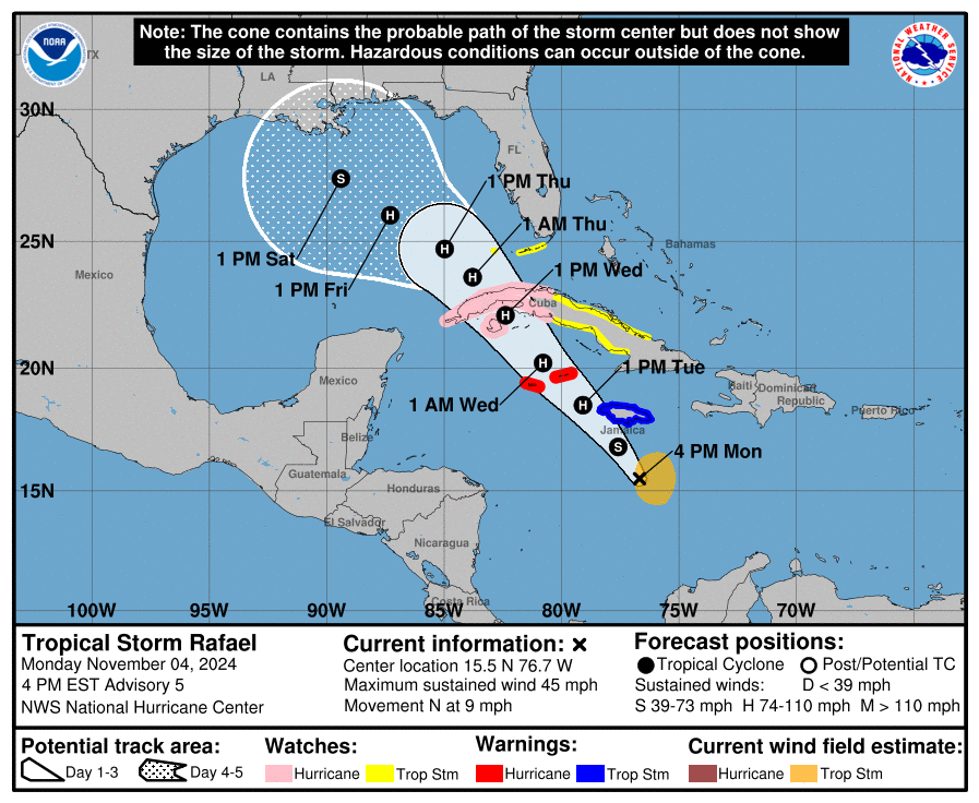
11/4/24 - TS Rafael Forms In The Caribbean, Headed For The Gulf

Tropical Storm Rafael has formed south of Jamaica and is poised to become a hurricane on Wednesday. Winds are expected to peak near 100 mph on Wednesday and could even get stronger than currently forecasted. Multiple watches and warnings are in effect along the projected path including a tropical storm watch for the Florida Keys. Rafael will emerge in the Gulf of Mexico later this week and a sharp increase in southwesterly wind shear, drier air, and slightly cooler waters should induce weakening as Rafael gets closer to the northern Gulf Coast.

If you are not already a premium graphics subscriber, sign up today and get higher-resolution storm graphics that contain more information so you can make informed decisions. It also helps support our app since we now offer it free. We want to be around for a long time!

Premium users will also have access to wind graphics that the NHC does not publish. Details & sign up here > Premium Graphics Info.

Thank you for being a Hurricane Tracker App user and supporting our passion for tracking tropical cyclones!

11/3/24 - Advisories Issued On Potential Tropical Cyclone 18

The NHC has issued advisories on Potential Tropical Cyclone 18 as there’s a high development chance. It should become TS Rafael during the next 24 hours and then a hurricane. It will impact Jamaica, The Cayman Islands and western Cuba during the next few days before it makes it to the Gulf of Mexico. Currently, there’s no imminent threat to the Gulf Coast. However, any potential Gulf threat from this system would be about a 5-6 days away so we will track and watch it closely. Check back periodically for updates on this system. Premium graphics will be available soon for subscribers.

If you are not already a premium graphics subscriber, sign up today and get higher-resolution storm graphics that contain more information so you can make informed decisions. It also helps support our app since we now offer it free. We want to be around for a long time!

Premium users will also have access to wind graphics that the NHC does not publish. Details & sign up here > Premium Graphics Info.

Thank you for being a Hurricane Tracker App user and supporting our passion for tracking tropical cyclones!

11/2/24 - Tracking Invest 97L

We’re tracking 97L in the Caribbean. Impacts to Jamaica, Cayman Islands, Cuba coming up early to mid week. Beyond that, does high pressure track it west or does a trough bring in into the NE Gulf? Not sure yet, only time will tell. Lots of time to monitor. Next name is Rafael.

If you are not already a premium graphics subscriber, sign up today and get higher-resolution storm graphics that contain more information so you can make informed decisions. It also helps support our app since we now offer it free. We want to be around for a long time!

Premium users will also have access to wind graphics that the NHC does not publish. Details & sign up here > Premium Graphics Info.

Thank you for being a Hurricane Tracker App user and supporting our passion for tracking tropical cyclones!