7/4/25 - Tropical Depression 3 Forms Off The SE U.S. Coast

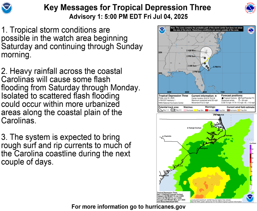
Tropical Depression 3 has formed off the coast of the SE U.S. coastline. It's forecasted to become TS Chantal and make landfall in SC early Sunday am. A Tropical storm watch is in effect for portions of the SC coastline. Rainfall of 2-4 inches, isolated up to 6 inches will be possible. This system will not become a hurricane. Stay tuned for updates and track in the “Current Storms” section in the app.

GO HI-RES! If you are not already a premium graphics subscriber, sign up today and take full advantage of what Hurricane Tracker has to offer. Details here > Premium Graphics Info. Thank you for being a Hurricane Tracker App user and supporting our passion for tracking tropical cyclones! We couldn’t do this without your support! 2025 will be our 15th year of tracking tropical systems!

Example image below of just one of our premium graphics offerings during an active storm.

Details here > Premium Graphics Info.

Thanks for your ongoing support and helping to keep this app active!

7/4/25 - Invest 92L Has a High Chance of Development

We are tracking Invest 92L about 150 miles off the northeast Florida coast. The system is becoming better defined, and a short-lived tropical depression or weak tropical storm may form later today and slowly track towards the SE U.S. coastline. Heavy rain and gusty winds will be the primary threats. The center should make landfall along the South Carolina coastline sometime on Saturday. The Hurricane Hunters are en route to investigate. Stay tuned for updates, and we hope everyone has a great 4th of July.

GO HI-RES! If you are not already a premium graphics subscriber, sign up today and take full advantage of what Hurricane Tracker has to offer. Details here > Premium Graphics Info. Thank you for being a Hurricane Tracker App user and supporting our passion for tracking tropical cyclones! We couldn’t do this without your support! 2025 will be our 15th year of tracking tropical systems!

Example image below of just one of our premium graphics offerings during an active storm.

Details here > Premium Graphics Info.

Thanks for your ongoing support and helping to keep this app active!

7/3/25 - Possible Development off SE U.S. Coast This Weekend

An area of low pressure is forecast to develop along the SE U.S. coast within the next few days. Any development would likely be weak & rain would be the primary issue. The NHC tropical outlook currently shows a 60% chance of development. Conditions would only be marginal for some slow development, and a strong system would be unlikely at this point. Regardless of development, periods of heavy rain will be possible the next few days along portions of the SE U.S. coastline. We will keep you updated on any changes. We hope everyone has a great 4th of July holiday!

The latest European Ensembles

GO HI-RES! If you are not already a premium graphics subscriber, sign up today and take full advantage of what Hurricane Tracker has to offer. Details here > Premium Graphics Info. Thank you for being a Hurricane Tracker App user and supporting our passion for tracking tropical cyclones! We couldn’t do this without your support! 2025 will be our 15th year of tracking tropical systems!

Example image below of just one of our premium graphics offerings during an active storm.

Details here > Premium Graphics Info.

Thanks for your ongoing support and helping to keep this app active!