Sally Threatening the Northern Gulf Coast, Paulette Headed For Bermuda, TD-20 Slowly Developing in the Open Atlantic

The tropics are extremely busy this morning as we continue through peak season. The NHC is watching four active tropical cyclones plus three more areas that might develop in the next five days.

This post will focus on Sally, Paulette, and TD-20 as the other systems are either no threat to land, or unlikely to develop in the near future.

The Hurricane Hunters have been investigating Sally this morning and found the storm a little stronger than last night. The center is still located northwest of most of the system’s thunderstorm activity, but that may be changing as new storms pop up farther northwest.

095214_5day_cone_no_line_and_wind.png

Sally is expected to strengthen steadily today and tomorrow as it moves WNW towards the Louisiana coastline. Landfall is expected Tuesday as a Category Two hurricane, though given a favorable environment for rapid intensification, I wouldn’t discount the possibility that Sally winds up being a Category Three before moving onshore. Either way, the main threats associated with Sally will be storm surge and extremely heavy rainfall, both of which will extend well east of the center. Even if you’re outside the cone of uncertainty in parts of the FL Peninsula, you need to take this storm seriously!

Residents in this area should be preparing for Sally now and should heed the advice of state and local officials particularly when it comes to evacuation orders.

Out in the Atlantic, Hurricane Paulette is strengthening this morning having finally moved into an environment with lower wind shear. Convection is wrapping all the way around the storm’s developing eye, and as a result strengthening should continue throughout the day. The storm is expected to make a close pass or direct hit on Bermuda tonight complete with hurricane-force winds, heavy rain, and storm surge. Conditions will begin to deteriorate on Bermuda soon, and residents there should rush their preparations to completion this morning.

After impacting Bermuda, Paulette will turn north and then northeast early this week. While no further direct impacts to landmasses are expected, the storm will send very large swells towards the East Coast this week and as a result, the risk for rip currents at exposed beaches will be greatly enhanced.

floater_floater_AL202020_Sandwich_12fr_20200913-0948.gif

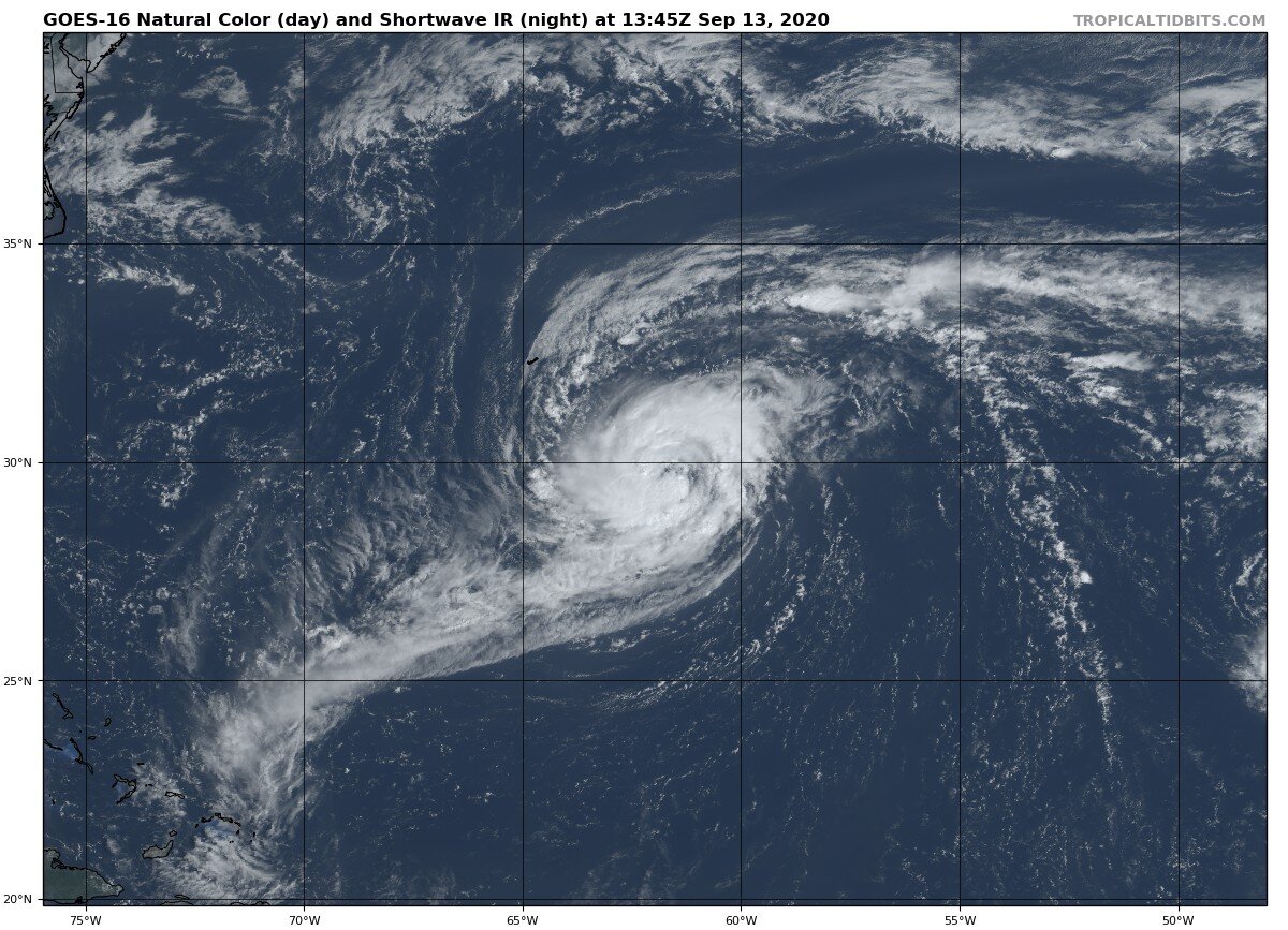
The last stop on our whirlwind tour of the tropical Atlantic is about half way between Barbados and Africa where Tropical Depression Twenty has been designated by the NHC. The satellite loop above shows a well-defined low-level swirl associated with the system (white clouds are close to the ground on this type of imagery) but most of the intense thunderstorm activity displaced off to the south/southwest. With a structure like this, TD 20 is likely to be slow to organize as it moves generally west-northwest in the next few days.

Current forecasts show TD-20 becoming a hurricane this week while turning northwest well before the Lesser Antilles. While it’s hard to say exactly where the storm will be a week from now, at the moment it looks like this system poses relatively little threat to land.

-Jack

Posted on 9/13/2020 by Jack Sillin with the Hurricane Tracker App. These posts are meant to provide our users with a detailed analysis of the tropics as conditions warrant and may not be updated on a daily basis. For the latest up to date storm information, always go to “Current Storms” and select a system for the latest information.

We will have another tropical weather discussion as conditions warrant. Thanks for using Hurricane Tracker.

Tap here to listen to our latest audio update by Hurricane Tracker forecaster Jack Sillin.

96L Likely to Develop in the Gulf of Mexico This Weekend, Paulette Expected to Recurve Well Offshore, 95L Worth Watching in the Longer Term

The Atlantic is quite busy this morning as we move through peak season during a time when seasonal and subseasonal dynamics (in addition to climatology) are strongly favorable for tropical cyclone development.

two_atl_5d0 (19).png

There are two named storms in the Atlantic this morning, Paulette and Rene, as well as four disturbances the NHC has highlighted for potential development in the next five days. This post will focus on the systems most likely to bring impacts to the US in some form or another. So we’ll start with the system most likely to bring direct impacts (rain/wind) to Florida and parts of the Gulf Coast. Then we’ll move onto the system likely to bring indirect impacts in the form of large swells to the East Coast (that’s Paulette) and finally we’ll wrap up by taking a quick look at 95L which is the system in the eastern Atlantic that has an outside shot at bringing impacts (either direct or indirect) in 7-10+ days.

Rene is barely a tropical storm this morning and will fade over the open Atlantic before bringing any impacts to any landmasses. The next disturbance emerging off Africa after 95L seems poised to follow Rene out to sea, though some impacts to the Cabo Verde Islands are possible. Finally, the disturbance in the western Gulf of Mexico will struggle with dry air and relatively stable conditions at least for the next 3-4 days so it doesn’t pose as much of a threat in my opinion. Interests in NE Mexico should still keep half an eye out in case that forecast changes.

dc2d78c0-547b-437b-88b8-fa48190597f5.jpg

96L looks quite healthy this morning with lots of deep convection (cloud tops below -70C) and upper-level outflow fanning out in a clockwise pattern away from the storms center. This is a signal that the sotrm has a healthy upper-level environment in which to organize and strengthen. Most model guidance, and NHC forecasts, do not suggest that 96L will be able to develop into a tropical depression or storm until it moves west of Florida tomorrow evening. However, if the system is able to maintain this much convection through the day today, I wouldn’t be surprised to see a depression or storm by tomorrow morning.

Either way, a rainy Saturday is on the way for southern Florida. Some of those showers will be breezy, especially if the storm is able to develop a consolidated low-level circulation. That said, at the moment I do not expect any significant issues from wind or surge as 96L moves through. If that changes and the storm looks like it’s really getting its act together, I’ll send out another update with the latest.

9-11-20 1.png

Model guidance is quite bearish on this system in the Gulf of Mexico, despite a mostly favorable environment. I think this is due mostly to most guidance showing the system moving more northwest than west over the next 36 hours. The farther north the storm goes, the less time it has to organize over the Gulf of Mexico, and the weaker it will be. A storm tracking farther west would give the storm more time to get its act together before making landfall on the northern Gulf Coast early next week.

Right now, the range of possible outcomes for 96L next week includes little/no development (low-impact showers in LA/MS/AL/FL Panhandle), some development into a TD/weak TS (heavy rain and some wind for parts of the northern Gulf Coast), or more substantial development into a strong TS or possibly even a low-end hurricane (heavy rain and wind for SE LA/MS). Right now, model guidance is strongly pointing towards the first two options. So it’s reasonable to treat those scenarios as the “most likely” outcomes. That said, any tropical system in the Gulf of Mexico in mid-September needs to be watched carefully for potential intensification and this is no exception. If you live anywhere from southern Louisiana east to the Florida Panhandle, you should be carefully tuned into forecasts this weekend and you should have your hurricane plan ready in case you need it. As of right now, there’s no need to be too concerned about this system but don’t be surprised if you have to give it some more thought come Sunday/Monday.

The next system to take a quick look at is Paulette which is currently fending off mid-level dry air and southwesterly shear over the central Atlantic.

This image shows current satellite imagery overlaid with Paulette’s forecast track. As you can see, the system is struggling with shear this morning and its deep convection is located northeast of its center. Shear is expected to relax today and tonight which should allow the storm to intensify into a hurricane as it approaches Bermuda. If you’re following along from Bermuda, you should keep a very close eye on Paulette and be ready to take appropriate preparedness actions if instructed by local officials. Serious direct impacts to Bermuda are possible from Paulette as the system passes close to the island on Monday.

ww3_wavehgt_eus_49.png

The biggest impacts to folks along the East Coast from Paulette will be large swells set to arrive Monday and continue through most of next week. Large swells will produce dangerous conditions at beaches exposed to the ocean as well as dangerous seas for mariners.

Last on our list for this post are these two waves in the far eastern Atlantic.

The western wave is trying to organize under that burst of thunderstorm activity SW of the Cabo Verde islands while the eastern wave is just now sliding off the African coastline. There’s still plenty of uncertainty regarding where each system will head over the next week or so, and a lot of that uncertainty can be tied back to how the waves interact today. The more they get tangled up with each other, the less of a threat the western wave will pose to land in the western Atlantic down the line. If they remain separate and the western wave is able to escape quickly to the west, we might have to worry about a hurricane heading towards the Lesser Antilles next week. Even if the systems were to interact in a way that’s favorable for land interaction later, there will be plenty of chances for the system to recurve into the open Atlantic or weaken before arriving in the US so as of now, I’m not too worried about this system. That very well may change a week from now though, so be sure to stay tuned for forthcoming updates.

-Jack

Posted on 9/11/2020 by Jack Sillin with the Hurricane Tracker App. These posts are meant to provide our users with a detailed analysis of the tropics as conditions warrant and may not be updated on a daily basis. For the latest up to date storm information, always go to “Current Storms” and select a system for the latest information.

We will have another tropical weather discussion as conditions warrant. Thanks for using Hurricane Tracker.