9/5/17 - Category 5 Irma Headed Towards The Caribbean, Bahamas & U.S.
Overview: Hurricane Irma continues to strengthen, and it's now a Category 5 storm with winds at 175 mph as of the 8AM advisory today. This storm will start to move west-northwest, beginning to affect many of the Leeward Islands with hurricane-force winds tonight. It will continue to move in a west- northwest direction through the next five days, getting very close to South Florida, but that’s when the uncertainty increases. If Irma moves over the island of Hispaniola or Cuba, that will allow for the storm to weaken, but unfortunately there's nothing else that is going to stop her from intensifying. Irma will remain a powerful major hurricane over the next several days.

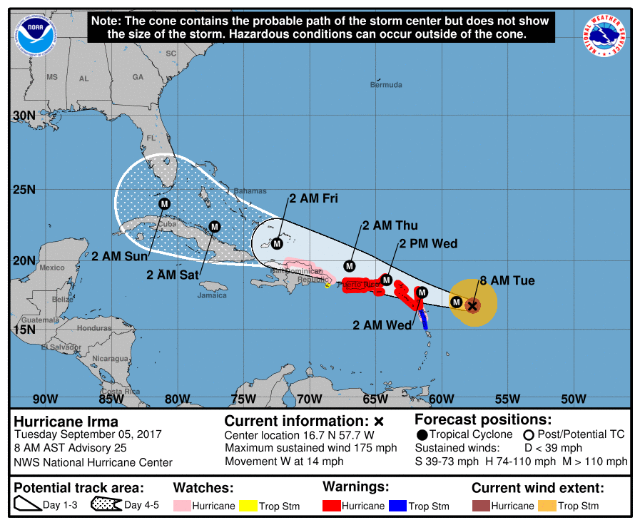
Watches/Warnings: A Hurricane Warning is in effect for Antigua, Barbuda, Anguilla, Montserrat, St. Kitts, Nevis, Saba, St. Eustatius, Sint Maarten, Saint Martin, Saint Barthelemy, British Virgin Islands, U.S. Virgin Islands, Puerto Rico, Vieques, and Culebra. A Hurricane Watch is in place for Guadeloupe. A Tropical Storm Warning is in effect for Guadeloupe and Dominica. Also, the government of the Dominican Republic has issued a Hurricane Watch from Cabo Engano to the northern border with Haiti and a Tropical Storm Watch from south of Cabo Engao to Isla Saon. See image below:

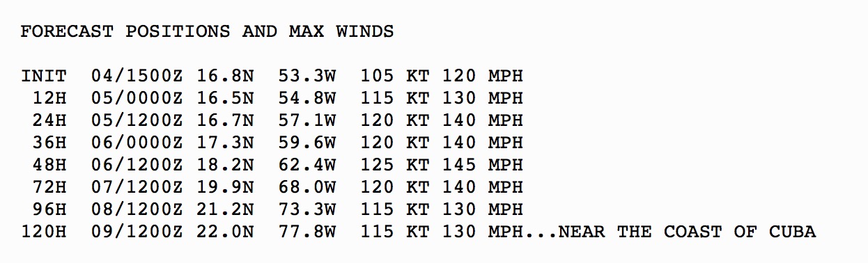
Intensity: Irma is forecasted to have winds greater than 150 mph through the next 5 days and winds may peak near 180 mph. The hurricane remains in a very favorable environment to maintain major hurricane intensity. Below is the current wind forecast from the NHC:

Track (Short-Term): There is a great deal of certainty in terms of the track of Irma for the next three of four days. Irma will track through or just north of the Leeward Islands Tuesday night into Wednesday morning, so hurricane-force winds are likely here. It will then move just north of the Virgin Islands and Puerto Rico on Wednesday, bringing heavy rain and gusty winds of at least tropical-storm-force. It will continue its west-northwest trek, moving north of the Dominican Republic and Haiti on Thursday. These countries will likely deal with the outer-rain bands as well as tropical-storm-force winds. Thursday night, the center of Irma will move very close to Turks and Caicos as a category 4 storm. Then on Friday and Saturday, at least the southern islands of the Bahamas will deal with the full ferocity of Irma. If you are in the NHC forecast cone, you need to be prepared. Always focus on the cone and not the exact forecast points. The Leeward Islands need to rush preparations to a completion by the afternoon as Irma nears even closer.

Track (Long-Term): The uncertainty of Irma increases by day five. At this point, there is the potential Irma makes landfall on South Florida and the Florida Keys. This morning’s model guidance has trended further south, however, so Cuba is also at risk of a landfall. If it takes this track, like some of the ensemble members show, it will move through Cuba then into the eastern Gulf, but at this point as a slightly weaker storm. If you are in Cuba or South Florida, you need to get prepared now. Even if a landfall is not guaranteed where you are, you may still deal with tropical-storm-force winds and it’s always good to be prepared just in case. There is still the chance Irma takes a sharp-right turn and heads out to sea before approaching Florida, but that chance continues to lower to almost zero. Also, the chances for direct impacts to the Northeast U.S. are lessening. A few of the ensemble members take Irma into the Northeast, but the main focus is on the Southeast U.S. Again, Florida has the highest chance for impacts at this moment, but the Carolinas and Georgia will also have to watch this storm closely if Irma decides to track up the eastern coast of Florida. If Irma makes its right turn a little later in the game, then the eastern Gulf Coast will be at risk. All interests from the eastern Gulf Coast through New England need to monitor the progress of this storm the next couple days as the forecast may still change.


Our new risk potential map.

Alert Levels: We have issued “Imminent” Alert Levels for the Leeward Islands, Virgin Islands, and Puerto Rico. Please review our kep below for recommended actions to take based on the alert level issued for your area.


Conclusion: Hurricane Irma will begin to impact of the Caribbean tonight. Land will remain at risk through the rest of Irma’s life as it track just north of the Caribbean Islands and towards the U.S. Irma is a very dangerous hurricane and anyone in the NHC cone should take this storm very seriously.
We will have another update on Hurricane Irma as conditions warrant. Thanks for using our service.
- Jackson Dill, Hurricane Tracker App Team