6/20/17 - Heavy Rainfall Headed For Gulf Coast & First Ever "Potential Tropical Cyclone" Forms

Update: Invest 93L is now Potential Tropical Cyclone 3 in the Gulf. Potential Tropical Cyclone 2 is now Tropical Storm Bret, east of the Caribbean. We will have an updated post later this evening. 

INVEST 93L (NOW POTENTIAL TROPICAL CYCLONE 3)

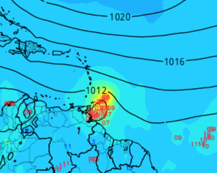
Overview -  Invest 93L is disorganized this am, but the overall low level structure has improved in the last 24 hours. Surface wind analysis shows more of an elongated trough axis and not a well defined low as of yet. Strong convection has been firing over the western Caribbean sea, east of the main surface trough axis. There is currently a high chance of development, 80% within 48 hours and 90% through the next 5 days.

If you would like to receive these updates the moment they are published, please click here to sign up for email updates.

rb0-lalo-5.gif

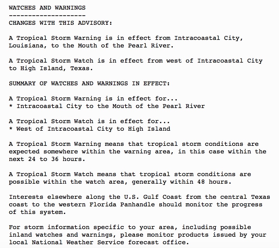
Watches/Warnings - Please review the current watches and warnings below:

Intensity - The atmospheric setup in the Gulf of Mexico is not favorable enough at this time to allow for much intensification. At this time, guidance does not suggest anything more than a moderate tropical storm with winds likely staying below 60 mph. While it can’t be completely ruled out, there is a less than 10% chance this system reaches hurricane intensity.

Track - There has been a consensus in the guidance that 93L will generally track towards the west or northwest portions of the Gulf of Mexico by midweek. The forecasted steering flow is complicated as the models are trying to handle an upper level trough over the western Gulf of Mexico, building high pressure over the southwest Atlantic and the southwest U.S., and a trough of low pressure over the Great Lakes. There’s agreement that the surface trough associated with 93L will move WNW today and a surface low will likely form in the south central Gulf of Mexico within the next 24 hours. Once the system is in the central Gulf, the models diverge. The GFS takes the system NNW towards the LA coastline while the EURO/UKMET models turn the system west towards the middle Texas coastline. It appears the models have different views on how much influence the upper level trough over the Gulf of Mexico will have on the tropical system. The GFS has been slowly shifting westward towards the EURO/UKMET and right now it appears the GFS is not handling the steering pattern as well as some of the other guidance. All interests from the lower TX coast to SE LA should monitor the future track of this system as it’s not set in stone yet.

Latest "spaghetti" model plots.

Latest "spaghetti" model plots.

Alert Levels - We have issued high alert levels for the NW and North-Central Gulf of Mexico for the potential of heavy rain which may lead to flash flooding and the possibly of coastal flooding due to higher seas to the north and east of the center. We do not expect this to be a wind event. Heavy rainfall will be the primary threat.

Impacts - Regardless of development, the main impacts from this system will be heavy rainfall and the possibly of tropical storm force winds up to 50-60 mph. Rainfall amounts to the north and east of the center may reach 6+ inches and up to 10-12 inches in localized areas. Coastal areas from the middle Texas coast to SE LA should expect minor coastal flooding issues.

Latest rainfall forecast from the EURO model. Note, the highest rain totals will be north and east of the center.

Latest rainfall forecast from the EURO model. Note, the highest rain totals will be north and east of the center.

Conclusion - If you are a resident or have interests along the Gulf of Mexico, please continue to check in throughout this week for updates on this system as we will be here with the latest information.

POTENTIAL TROPICAL CYCLONE 2 (NOW TS BRET)

Overview - The National Hurricane Center now has the option to name tropical systems when there is a high chance of development and the threat of tropical storm or hurricane force winds within 48 hours. These systems will be designated as “Potential Tropical Cyclones” (PTC) and the NHC will issue advisories just as they would on a real active system. Invest 92L was upgraded to Potential Tropical Cyclone 2 yesterday as it’s forecasted to become a tropical storm and bring ts force winds to the southern portions of the Lesser Antilles over the next 24-36 hours. Once the system reaches the Caribbean Sea, we expect the system to weaken back into an open wave due to increasing wind shear that it will encounter as it moves west.

Watches/Warnings - Tropical storm warnings are currently in effect, please review the image below.

Intensity - Based on the latest guidance, we expect this system to attain tropical storm status before weakening back into an open wave once it reaches the Central/Eastern Caribbean Sea on Wed/Thu due to increasing wind shear.

Track - The track forecast is fairly straightforward, the system will generally track towards the west-west northwest over the next couple of days generally towards the southern Lesser Antilles in the eastern Caribbean Sea. 

Alert Levels - Since there’s high confidence in the future development of this system, we have issued imminent alert levels for the southern half of the Lesser Antilles. Minor impacts are possible within the next 23-48 hours. Tropical Storm Warnings are in effect.

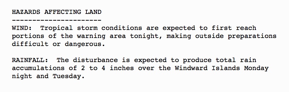
Impacts - Please review the image below for impacts as of the latest NHC advisory.

Conclusion - The fact that we have such a strong tropical wave with the potential to develop is very rare for mid June. It’s also historic in the fact that this is the first system the NHC has designated as a Potential Tropical Cyclone. The NHC is certainly doing a better job at informing the public when there’s a threat of a system developing and impacting land. It’s absolutely the right decision. You will now find information in the app on Potential Tropical Cyclones, look for the new blue storm icon in the overview and current storm sections.

We will have another discussion tomorrow. Thank you for using Hurricane Tracker and have a great week!

6/18/17 - Tracking Invest 92L & 93L. Impacts Possible Within 3-5 Days

INVEST 93L NEAR THE YUCATAN

Overview - Lots to discuss, let's get to it. There’s currently a large area of disturbed weather in the western Caribbean Sea. Surface pressures have continued to fall and the aerial coverage of disturbed weather has continued to increase. Conditions appear favorable for gradual development of the system as it moves slowly northwestern across the Yucatán peninsula this weekend and into the south-central Gulf of Mexico over the next 2-3 days. As of this writing, this system has a 70% chance of development over the next two days and a 90% chance of development through the next five days. 

If you would like to receive these updates the moment they are published, please click here to sign up for email updates.

Latest audio update here: http://bit.ly/2sHRQDm

Watches/Warnings - There are currently no watches or warnings associated with this system.

Intensity - This system is not expected to become anything more than a tropical storm over the next five days. There is less than a 10% chance this could become a hurricane. There is still a slight chance this system may become nothing more than an interest or a depression.

Track - Based on the latest guidance, it appears this system will eventually impact a portion of the U.S. Gulf coast. The exact track cannot be pin-pointed yet, but landfall will likely occur somewhere between the lower TX coast and SE LA Tues/Wed. We hope to be able to narrow this down a little further by tomorrow.

eurpeps.png

Alert Levels - We have issued low - elevated alert levels for a portion of the Gulf Coast as there are still a couple of tracks scenarios for this system. We want to stress that the main impacts from this system, regardless of development, will be heavy rainfall to the north and east of where the center tracks. Below you will find the precipitation forecast for the european and the GFS American model. At this time, we can't say exactly where the storm will track or which areas along the Gulf Coast will see heavy rainfall and gusty winds. Stay tuned to future outlooks.

Impacts - Regardless of development, the main impacts from this system will be heavy rainfall and the possibly of low end tropical storm force winds. This will not be a classic tropical cyclone in terms of organization. Broad, sloppy and wet is the theme here.

6/18/17 12Z EURO precipitation forecast. We could see over a foot of rain well north and east of the center.

6/18/17 12Z EURO precipitation forecast. We could see over a foot of rain well north and east of the center.

Conclusion - If you are a resident or have interests along the Gulf of Mexico, please continue to check in throughout this weekend for updates on this system as we will be here with the latest information. There's no immediate risk with this system.

INVEST 92L IN THE EASTERN ATLANTIC

Overview - A strong tropical wave has formed in the eastern Atlantic basin and has been designated Invest 92L by the hurricane center. As of this writing, it currently has a 60% chance of development over the next two days and a 60% chance through the next five days. This system has the potential to affect portions of the eastern Caribbean Sea through the next five days. Once the system reaches the Caribbean Sea, we expect the system to weaken back into an open wave due to increasing wind shear that it will encounter as it moves west.

Watches/Warnings - There are currently no watches or warnings associated with this system.

Intensity - Based on the latest guidance, we expect that if this system develops it could easily reach tropical storm status. At the present time, we’re not expecting this to become anything more then a moderate tropical storm. Weakening is expected next week if it reaches the Caribbean Sea due to increasing wind shear to its west. Right now, the environment is favorable.

This system is forecasted to weaken in the Caribbean next week and it encounters increasing wind shear. Environment until then is favorable.

This system is forecasted to weaken in the Caribbean next week and it encounters increasing wind shear. Environment until then is favorable.

Track - The track forecast is fairly straightforward, the system will generally track towards the west-west northwest over the next several days generally towards the southern Lesser Antilles in the eastern Caribbean Sea. A ridge of high pressure to the north of the system is the main steering influence.

GEFS ensemble forecast for Tuesday.

GEFS ensemble forecast for Tuesday.

Alert Levels - Since there’s medium confidence in the future development of this system, we have issued elevated alert levels for the southern half of the Lesser Antilles. Minor impacts are possible within the next 5 days.

Impacts - If the system develops and tracks towards the southern Lesser Antilles as anticipated, the main impacts would be tropical storm force winds of 40-60 mph and heavy rainfall. The system is expected to pass through the region on Tuesday and Wednesday of next week.

Conclusion - If this invest does indeed develop into a tropical cyclone, it will be a very rare event for this time of year as only 4 tropical cyclones have formed in the open Atlantic during the month of June. We can not ever recall seeing such a very impressive, well structured wave in the main development region this early in the season. Invest 92L is in a very conducive environment, at least for the next 2-3 days. We believe this is a sign that the tropical Atlantic could be busier than we've seen over the last several seasons. Furthermore, there are more strong tropical waves poised to move off of Africa over the next 7 to 10 days. 

If you are a resident or have interests in the eastern Caribbean, please check in often as new data comes in. Thank you for using our service, we appreciate all of our users. Enjoy your weekend.

We will have a new post later today.