
Invest 97L May Become Matthew & Impact The Eastern Caribbean Mid Week
We will have a new discussion posted sometime today on Invest 97L.
The Atlantic basin has been active recently as we have tracked Tropical Storms Ian, Julia, Karl and Lisa. Of course, most of these systems posed little to no threat to land except for Karl which brought tropical storm conditions to Bermuda and Julia which brought heavy rains to portions of the southeast U.S. We now turn our attention to the next tropical wave that came off Africa a couple of days ago. It has been designated as Invest 97L by the National Hurricane Center.
The NHC currently states there is a 90% chance of development through 5 days as environmental conditions should become more favorable for development as it tracks west.

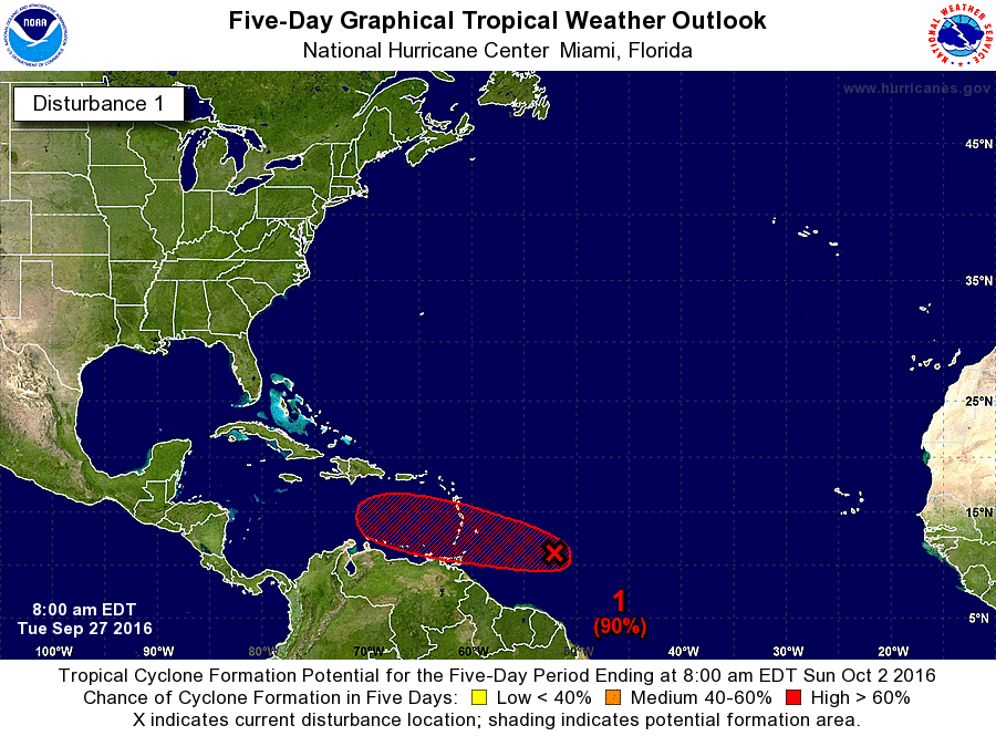
Invest 97L is at a low latitude and the chances of it recurving before the Caribbean are very low as it will be steered west by a deep layer ridge of high pressure to its north. For many runs, the models have been adamant on developing this system into a tropical storm within 5 days and possibly our next hurricane in the 6-10 day range.

Confidence is growing that a tropical cyclone may affect a portion of the Lesser Antilles around mid-week. At this time, it's too early to know what the intensity may be as it passes through the islands, but Tropical Storm Matthew seems plausible given the remarkably consistent model data. Beyond the Lesser Antilles, we can't say with any certainty whether this system would affect more land areas or the U.S., but it certainly can't be ruled out. Models are showing favorable conditions for most of this system's life and it will be traversing water temperatures that are at least in the mid 80's and extend deep beneath the ocean surface.
If you have interests in the Eastern Caribbean, please pay close attention to this system over the next 7 days as it tries to develop. Check out our 5 Day Alert Level Map below. We will be here with continued updates as new data comes in. Unfortunately, this may be one to watch very closely down the road as there is not really a door out to sea as we saw with Ivan, Karl and Lisa. Have a great weekend everyone. We will have a new update by Monday evening.


